Planning and Regulatory Committee
– Terms of Reference
Fields of
Activity
Oversight of all
matters relating to the Council’s planning and regulatory functions and the
development of policies and strategies in relation to those functions.
The matters within this committee’s responsibilities include (but are not
limited to):
·
Resource Management Act
1991
·
Building Control
including the Building Act 2004 and the New Zealand Building Code
·
Bylaws
·
Health Act 1956
·
District Plan
·
Historic Places Act
1993
·
Security Patrol
·
Maritime Planning Schemes
Other regulatory
matters including:
·
Animal and pest
control,
·
Dangerous goods and
Hazardous substance,
·
Fencing of swimming
pools,
·
Litter,
·
Alcohol,
·
Noise abatement,
·
Public health and
safety,
·
Prostitution,
·
Gambling,
·
Parking control.
·
Responsibility for all
matters related to the District’s environment including the environment
of neighbouring districts and water bodies
·
Other Regulatory
matters not otherwise defined.
Membership
Chairman appointed
by the Council
Deputy Chairman
appointed by the Council
The Mayor
All Councillors
Quorum – 8 members
DELEGATED
POWERS
General Delegations
1. Authority to
exercise all of Council powers, functions and authorities (except where
delegation is prohibited by law or the matter is delegated to another committee)
in relation to all matters detailed in the Fields of Activity.
2. Authority to
re-allocate funding already approved by the Council as part of the Long Term
Plan/Annual Plan process, for matters within the Fields of Activity provided
that the re-allocation of funds does not increase the overall amount of money
committed to the Fields of Activity in the Long Term Plan/Annual Plan.
3. Responsibility to
develop policies, and provide financial oversight, for matters within the
Fields of Activity to provide assurance that funds are managed efficiently,
effectively and with due regard to risk.
4. Responsibility to monitor Long Term Plan/Annual Plan
implementation within the Fields of Activity set out above.
Bylaws
5. Authority to review
bylaws and to recommend to the Council that new or amended bylaws be made
including but not limited to the review of bylaws made pursuant to rules under
the Land Transport Act 1998, (primarily relating to speed limits) and bylaws
relating to parking.
Legal proceedings
6. Authority
to commence, compromise and discontinue mediations, legal proceedings,
prosecutions and other proceedings within the Fields of Activity.
Fees and
Charges
7. Except
where otherwise provided by law, authority to fix fees and charges in relation
to all matters within the Fields of Activities.
Resource
Management/Environmental issues
8. Authority
to make submissions on behalf of the Council in respect of any proposals by
another authority under any legislation, or any proposed statute which might
affect the District’s environment or the well being of its residents
including such matters as adjacent local authorities’ district plans, any
regional policy statement, and Regional Plans.
REPORT TO: Planning
and Regulatory Committee
MEETING DATE: Thursday 8
February 2018
FROM: Special Projects and Parking
Management Assistant
Kevin
Deacon
SUBJECT: Parking
Controls
1.0 SUMMARY
1.1 The purpose of
this report is to obtain a decision from the Committee on a number of changes
to parking controls throughout the District.
1.2 The proposals
arise from requests for new parking controls and an amendment to an existing
control.
1.3 The Council is
required to give effect to the purpose of local government as prescribed by
Section 10 of the Local Government Act 2002. That purpose is to meet the
current and future needs of communities for good quality local infrastructure,
local public services, and performance of regulatory functions in a way that is
most cost–effective for households and businesses. Good quality means
infrastructure, services and performance that are efficient and effective and
appropriate to present and anticipated future circumstances.
1.4 The objective of
this decision relevant to the purpose of Local Government is the provision of
quality infrastructure and local public service.
1.5 This report
concludes by recommending ;
A) That a 60 minute time limit
be established on Avenue Road East
B) That a 5 minute time limit be
established on school days on Karamu Road South.
C) That the 60 minute time limit on
Queen Street East be revoked and a 120 minute time limit be established.
D) That a Loading Zone be established
on Queen Street East
E) That the Loading Zone on
Avenue Road East have a 5 minute time limit added.
2.0 BACKGROUND
2.1 From time to time
it is necessary to introduce parking controls and or amend those that are
already in place.
2.2 In order that the
changes are legally established these need to be formally resolved by Council.
2.3 The following
table provides the background and current situation relevant to the various
changes being proposed:
|
Avenue Road East
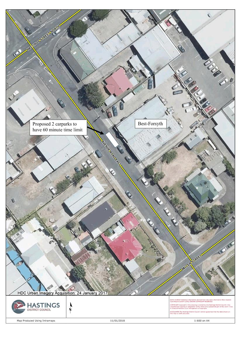
Officers were approached by the owner of Best-Forsyth Electrical,
at 404 Avenue Road East, advising that due to all-day parking by those
working in the immediate area, that customers and couriers were finding it
difficult to access the business.
An occupancy survey was carried out from Monday 18 September to
Friday 22 September 2017 which showed the overall average to be 93%.
It is generally accepted as a national standard that if occupancy
levels are in excess of 85% a motorist will normally have difficulty finding
a carpark within close proximity to their destination.
Individual carparks have been subsequently marked on the road to
maximise the on-street parking, but it is proposed that 2 spaces directly
outside the business have a 60 minute time limit established to provide
regular turnover of the spaces, thus enabling ready access for customers and
delivery vehicles-see Attachment 1.
|
|
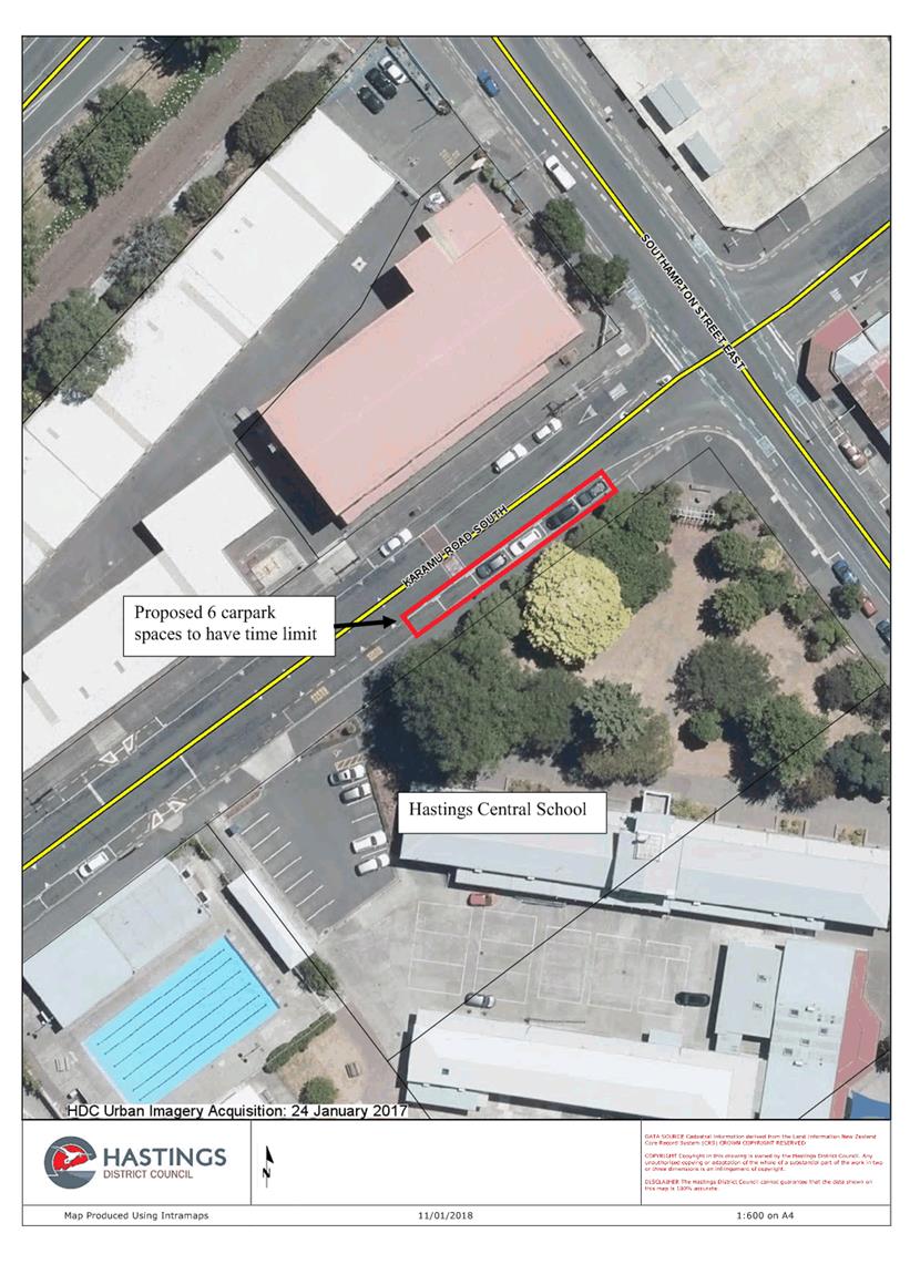
Karamu Road South-Hastings Central School
The management at Hastings Central School have approached Council
expressing concern that there is a lack of parking near the school entrance
for parents/caregivers to deliver and collect students from the school.
An occupancy survey was carried out from Monday 30 October to
Friday 3 November 2017, which showed an overall average of 76% for the
immediate area.
The survey showed that there were a number of vehicles parking in
the area all day and therefore making it difficult for parents/caregivers to
access parking near the school entrance.
It is proposed to establish a 5 minute time limit, for 6 spaces,
to apply from 8.00am to 9.00am and 2.30pm to 3.30pm on school days, being
similar to parking controls that currently exist at a number of schools
throughout the District – see Attachment 2.
|
|
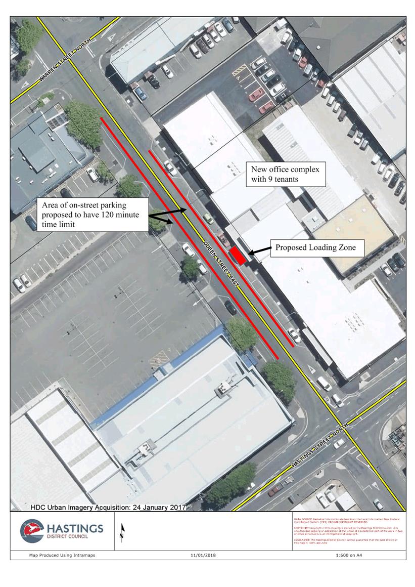
Queen Street East
Officers have been approached by the management at Fernridge Fresh,
who are based in the new office complex at 308 Queen Street East, requesting
that the 60 minute time limit in front of the offices be extended.
They have found that many of their meetings with clients extend
beyond the one hour time limit and as a result their clients have incurred
infringement notices.
They advised that their business also generates a number of
courier movements on a daily basis and especially during the export season
and suggested that a Loading Zone be established to help Couriers and
delivery vehicles to gain ready access to the complex.
It is proposed that the existing 60 minute time limit be extended
to 120 minutes and that a Loading Zone be established central to the office
complex’s main entrance-see Attachment 3.
|
|
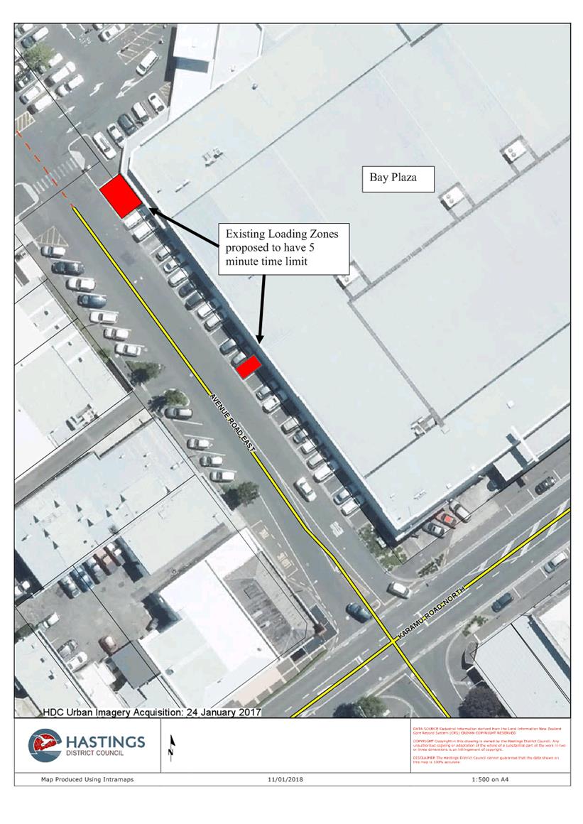
Avenue Road East-Bay Plaza
At the Planning and Regulatory Committee meeting on 11 February
2014, it was resolved to establish a new Loading Zone and to also extend an
existing Loading Zone on Avenue Road East, following the upgrade of the Bay
[K Mart] Plaza –see Attachment 5.
While the Loading Zones were formally resolved, there were no time
limits included in the resolutions.
All other Loading Zones throughout the district have a 5 minute
time limit and for consistency it is proposed that the two areas in Avenue
Road now have the same time limit added.
|
3.0 OPTIONS
3.1 The options
available to Council are to:
A) Approve the changes being
proposed
OR
B) Not approve all or some of
the changes being proposed
4.0 SIGNIFICANCE AND ENGAGEMENT
4.1 The matters in this
report are not significant in terms of Council’s Significance Policy.
4.2 Avenue Road
East
Because the 2 parking
spaces, proposed to have a 60 minute time limit, are directly outside the
business that has requested the controls be established, no other businesses in
the area are likely to be affected and no other consultation has been
undertaken.
4.3 Karamu Road
South- Hastings Central School
The request for the
parking controls has come from the school management and because there are no
other businesses in the immediate area, no other consultation has been
undertaken.
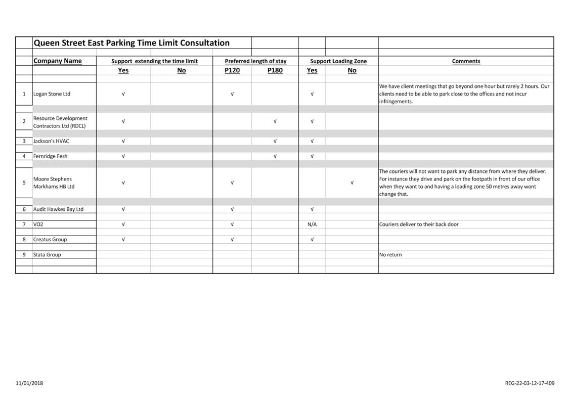
4.4 Queen Street
East
Following
the request for the time limit to be extended and for a Loading Zone to be
established, a letter was delivered to each of the other 8 businesses occupying
office space in the new complex.
All
but one business has responded to the letter.
All
businesses supported extending the time limit and all but one business
supported establishing a Loading Zone, while 5 of the 8 businesses supported
the time limit being extended to 120 minutes the remaining 3 were wanting it
extended to 180 minutes - see Attachment 4.
4.5 Avenue
Road East- Bay Plaza
Because
identifying the Loading Zone as having a 5 minute time limit is just a
formality no consultation was deemed necessary.
5.0 ASSESSMENT
AND PREFERRED OPTIONS
5.1 Avenue
Road East
Officers
support the introduction of the time limit for the 2 carpark spaces.
It
will help to provide ready parking for customers, couriers and delivery
vehicles wanting to access the Best-Forsyth office and workshop by ensuring
that there is a regular turnover of the spaces.
5.2 Karamu
Road South- Hastings Central School
Officers
support the introduction of the time limit.
It
replicates time limits that apply at other school entrances throughout the
district and it will ensure that there is a regular turnover of the spaces in
turn providing the opportunity for parents/caregivers to park close to the
school entrance when dropping off or picking up their children.
5.3 Queen
Street East
Officers support extending of the time
limit in this section of Queen Street and establishing a Loading Zone.
This will
provide parking that will meet the needs of the businesses that are operating
out of the newly established complex.
5.4 Avenue
Road East - Bay Plaza
Introducing
the 5 minute time limit will bring the two parking areas in line with the other
Loading Zones that exist throughout the district.
|
6.0 RECOMMENDATIONS AND REASONS
A) That the
report of the Special Projects and Parking Management Assistant titled
“Parking Controls” dated 8/02/2018 be
received.
B) That the Council resolve pursuant to Clause 5.3.1(a)(i) of Chapter
5 (Parking and Traffic) of the Hastings District Consolidated Bylaw 2016,
that 2 carpark spaces on the northern side of Avenue Road East, commencing at
a point approximately 53.6 metres from the intersecting kerbline with
Hastings Street North and extending in an easterly direction for
approximately 11 metres be resolved to have a 60 minute time limit.
C) That the Council resolve pursuant to Clause 5.3.1(a)(i) of Chapter
5 (Parking and Traffic) of the Hastings District Consolidated Bylaw 2016,
that 6 carpark spaces on the eastern side of Karamu Road South, commencing at
a point approximately 17.7 metres from the intersecting kerbline with
Southampton Street East and extending in an southerly direction for
approximately 34.3 metres be resolved to have a 5 minute time limit between
8:15am to 9am and between 2.45pm to3:30pm on school days.
D) That the
Council resolve pursuant to Chapter 5(Parking and Traffic) of the Hastings
District Council Consolidated Bylaw 2016, that the one hour time limit
applying to all the parking on Queen Street East, between Hastings Street
North and Warren Street North be revoked.
E) That the Council resolve pursuant to Clause 5.3.1(a)(i) of Chapter
5 (Parking and Traffic) of the Hastings District Consolidated Bylaw 2016,
that all the parking on Queen Street East, between Hastings Street North and
Warren Street North be resolved to have a 120 minute time limit.
F) That the Council resolve pursuant to Clause 5.3.1(a)(iv) of
Chapter 5 (Parking and Traffic) of the Hastings District Consolidated Bylaw
2016, that one carpark space on northern side of Queen Street East,
commencing at a point approximately 58 metres from the intersecting kerbline
with Hastings Street North and extending in a westerly direction for
approximately 9.5 metres be resolved to be a Loading Zone with a 5 minute
time limit.
G) That the Council resolve pursuant to Clause 5.3.1(a)(iv) of
Chapter 5 (Parking and Traffic) of the Hastings District Consolidated Bylaw
2016, that the Loading Zone on northern side of Avenue Road East, commencing
at a point approximately 49 metres from the intersecting kerbline with Karamu
Road North and extending in a westerly direction for approximately 2.5 metres
be resolved to have a 5 minute time limit.
H) That the Council resolve pursuant to Clause 5.3.1(a)(iv) of
Chapter 5 (Parking and Traffic) of the Hastings District Consolidated Bylaw
2016, that the Loading Zone on the northern side of Avenue Road East,
commencing at a point approximately 85.2 metres from the intersecting
kerbline with Karamu Road North and extending in a westerly direction for
approximately 7 metres be resolved to have a 5 minute time limit.
With the reasons for this decision
being that the objective of the decision will contribute to the performance
of regulatory functions in a way that is efficient and effective and
appropriate to present and future circumstances by:
i) Providing parking spaces in relevant places within the district
that are safe and readily available to motorists.
|
Attachments:
|
1
|
Avenue Road East Time Limit
|
REG-22-03-12-18-415
|
|
|
2
|
Karamu Road South Time Limit
|
REG-22-03-12-18-416
|
|
|
3
|
Queen Street East Time Limit and Loading Zone
|
REG-22-03-12-18-417
|
|
|
4
|
Queen Street Consultation
|
CG-14-4-00054
|
|
|
5
|
Avenue Road East Loading Zones
|
REG-22-03-12-18-418
|
|
REPORT TO: Planning
and Regulatory Committee
MEETING DATE: Thursday 8
February 2018
FROM: Group Manager: Planning & Regulatory
John O'Shaughnessy
Senior Environmental Planner (Policy)
Anna
Summerfield
SUBJECT: Te
Mata Track
1.0 SUMMARY
1.1 The purpose of this report is to inform the Committee about the adequacy
of the Proposed District Plan provisions as they apply to the Outstanding
Natural Features and Landscapes identified within the Hastings District,
particularly in respect of ONFL1 – Te Mata Peak and to seek guidance on
whether changes need to be made to the Proposed Plan to better safeguard the
cultural and visual values of Te Mata Peak.
1.2 This issue arises
from the effects of the construction of a new walkway by the Craggy Range
Winery on the eastern side of Te Mata Peak (ONFL1).
1.3 The Council is
required to give effect to the purpose of local government as prescribed by
Section 10 of the Local Government Act 2002. That purpose is to meet the
current and future needs of communities for good quality local infrastructure,
local public services, and performance of regulatory functions in a way that is
most cost–effective for households and businesses. Good quality means
infrastructure, services and performance that are efficient and effective and
appropriate to present and anticipated future circumstances.
1.4 The objective of
this decision relevant to the purpose of Local Government is to perform
regulatory functions which promote the best use of natural resources and which
are responsive to community needs with particular reference to providing
responsive Council planning services.
1.5 This report
concludes by recommending that the Committee receive the information and
provide guidance on whether changes should be made to the Proposed District
Plan to give greater protection to Te Mata Peak (ONFL1).
2.0 BACKGROUND
2.1 The Outstanding
Landscapes and Features of the district were first identified in the Operative
District Plan. The operative district plan was informed by the Outstanding
Landscapes Report which was undertaken by Isthmus Group in 1996.
2.2 This report
identified 8 Outstanding Natural Features and Landscapes within the district
including Te Mata Peak- both the west and east faces. The Isthmus Report
identified that the significance of the east face of Te Mata Peak is largely
derived from its sculptural and picturesque landform including “the
openness and uniformity of grass cover that enables the landform shape to be
appreciated and the play of light and shadow to accentuate its form”. It
also identified that while Kahuranaki is the identifying Maunga for all of
Ngati Kahungunu Te Mata is significant for hapu around the south east margins
of the plains.
2.3 At the outset of
the review of the District Plan it was necessary to undertake a review of the
1996 Isthmus Report to ensure that the best practice for landscape assessment,
legislative changes e.g. the New Zealand Coastal Policy Statement 2010, and
relevant case law, was taken into account in establishing the important
landscapes of the district.
2.4 A new scoring
method was utilised for the review of the outstanding landscapes and this was
not additive as compared to the assessment undertaken in 1996. The review
resulted in the retention of Te Mata Peak east and west faces as Outstanding
Natural Features and Landscapes. A Maori cultural review of the outstanding
landscapes was also undertaken by Bayden Barber of Ipurangi Developments Ltd,
and this was an important component of the each of the outstanding landscapes.
2.5 The cultural
review provided the korero of all the outstanding landscapes (including Te
Mata), and stated that all of the outstanding landscapes are of special
significance to Maori, and should be retained as such, to protect them from
development and degradation.
2.6 A new landscape
section was drafted as a result of the review of the Outstanding Landscapes
report and the accompanying cultural
review.
3.0 CURRENT SITUATION
3.1 The resource
consent that granted approval for the track on the east face of Te Mata Peak
has raised questions as to whether the current Proposed
District Plan framework adequately achieves the outcomes sought in respect of
the Outstanding Natural Features and Landscapes identified in the District,
particularly in respect of ONFL 1 – Te Mata Peak.
3.2 Te Mata Peak is
primarily located within the Rural Strategic Management Area (SMA) and Zone of
the District Plan. However part of the western face of the Peak is zoned
Te Mata Special Character Zone and therefore lies within the Havelock North
SMA. On top of these zones are the following overlays: the Te Mata
Special Character Zone lifestyle limit, the Prohibited Building Area, and the
Outstanding Natural Feature, Outstanding Natural Landscape areas and a Special
Amenity Landscape Area (SAL6). There are also several archaeological sites
noted on the planning maps across the whole of the Te Mata Peak range (however
there were no mapped archaeological sites located on the site subject to the
walking track application). Heritage New Zealand has subsequently stated that
the archaeological sites in the vicinity of the track may not be accurately
located.
3.3 A review of the
current anticipated outcomes, objectives, policies and rules of 17.1 (Natural
Features and Landscapes), and Section 27.1 (Earthworks Mineral Aggregate and
Hydrocarbon Extraction) has been undertaken. Relevant extracts of these
of outlined below to assist in the assessment.
3.4 The following are
the relevant anticipated outcomes, objectives and policies for Section 17.1:
Anticipated Outcomes
LSAO1 The values of important natural features and landscapes are not
compromised by inappropriate building development, earthworks, and the siting
of building development or plantations.
LSAO3 There is a greater public awareness of the different landscape
areas throughout the District and the activities that could have an adverse
effect on the key elements, patterns and character that contribute to the
significance of those landscape areas.
LSAO4 Buildings do not visually intrude on the natural form of rural and
coastal ridgelines and spurs
LSAO5 Large scale earthworks do not visually intrude on the natural form
of rural and coastal ridgelines, spurs and hill faces.
3.5 OBJECTIVE LSO1
The factors,
values and associations that define the District's Outstanding Natural Features
and Landscapes are identified, and are protected from inappropriate
subdivision, use, and development.
3.6 POLICY LSP1
To identify and
recognise the Districts Outstanding Natural Features and Landscapes by the
following criteria, factors, values and associations:
Explanation
3.7 In implementing
its Landscape Areas Policy the District Plan has targeted those landscapes
which are considered to be pre-eminent in the District. The District Plan
schedules Outstanding Natural Features and landscapes (and ranks below this the
Significant Amenity Landscapes, Rural Character Landscapes, and Coastal
Character Landscapes), identified as a result of the Landscapes Assessment, as
well as listing the key elements, patterns and character that contribute to
their significance. All the identified landscapes are listed in Appendices 43
(ONFL), 44 (SAL), 45 (RCL), and 46 (CCL), and are shown on the Planning Maps.
3.8 Outstanding Natural
Features and landscapes are listed in Appendix 43. Provision has been
made for the protection of the particular factors, values and associations that
make an area an outstanding natural feature and landscape from the adverse
effects of inappropriate subdivision, use and development, throughout the
District Plans rules, standards and assessment criteria.
3.9 The above
objective and policy sets out how and why the District’s ONFL’s are
identified and the hierarchy of landscape protection within the District
Plan. The following policies provide more specific detail regarding the
philosophy and rationale behind the rules within the ONFL’s. Te
Mata Peak is the only ONFL that has a specific policy which affords it’s
the highest priority for protection within the District Plan. No other
Outstanding Natural Feature or Landscape within the District is singled out in
this manner. The reasons for this appear to stem from its status as a
landscape icon for all residents of the District and in particular Maori and
the concern that there is a high probability or potential for new development
activities to occur and therefore to have adverse effects on the landscape
values and natural character of the Te Mata ONFL.
POLICY LSP2
3.10 Protection of the
present landscape qualities of Te Mata Peak shall be afforded the highest
priority through the District Plan.
Explanation
3.11 Te Mata Peak is a
significant landscape icon in Hawke's Bay, having District, Regional and
National significance. It is the most prominent landmark in the eastern
Heretaunga Plains with a distinctive silhouette skyline. It is a source of
identity for hapu, Ngati Kahungunu, and the Districts residents.
3.12 In order to ensure the
protection and integrity of the landscape, the Plan prohibits buildings
associated with residential activities and visitor accommodation above and
including the 240 metre contour line of the Peak. In addition, it requires that
resource consent for a Non-Complying activity be obtained for all other
buildings above and including the 240 metre contour line, and for all buildings
greater than 50m2, network utilities, earthworks and plantations within ONFL1.
The Prohibited and Non-Complying activity status of these activities provides a
clear signal to the community and Council that the present landscape qualities
of Te Mata Peak will be afforded the highest levels of protection.
3.13 Policy LSP2 above
confirms an intention that earthworks (as well as other specific activities
mentioned) within ONFL1 will require a non-complying activity. This
intention, in respect of earthworks activities, has not been translated into
the rules of Section 17.1 or Section 27.1 and therefore Policy LSP 2 is not
given proper effect to.
3.14 Earthworks associated
with new buildings up to 50m2 and below the prohibited building line, and
earthworks as a result of new track formation or for other recreational
activity are not mentioned in the Section 17 activity table and are therefore
permitted activities under this Section by Rule LS1.
3.15 Within the Earthworks
Section 27.1, earthworks are permitted activities up to 50m3 per site within
ONFL’s in the Havelock North SMA (Te Mata Special Character Zone) and up
to 200m3 (or 500m3 for existing track, drain or fence maintenance) per site within
ONFL’s in the Rural SMA (the majority of Te Mata Peak) and subject to
meeting the general performance standards and terms. Permitted activities
that do not meet the standards and terms become restricted discretionary
activities (Rule EM6).
3.16 The assessment
criteria for restricted discretionary activities not meeting the standards
includes the following matters:
EARTHWORKS WITHIN
OUTSTANDING NATURAL LANDSCAPES (ONFL)
Earthworks within
an ONFL will be designed and located to minimise adverse visual effects. In
particular, the extent to which any such development will:
(a) Where
practicable, minimise the location of large scale earthworks on prominent rural
ridgelines, hill faces and spurs.
(b) Be designed to
minimise cuttings across hill faces and spurs.
(c) Where
practicable, minimise the number of finished contours that are out of character
with the natural contour.
(d) Demonstrate
what visual mitigation is proposed to minimise the visual intrusion of the
work, including proposals to ensure the successful establishment of any
plantings.
3.17 The list above does
not refer to cultural impacts of earthworks activities on the Outstanding
Natural Feature and Landscape area. All ONFL’s in the District have
been identified as being culturally significant landscapes in the report
prepared by Ipurangi Developments Limited, in 2012. Therefore such
considerations should be included in assessment criteria relating to activities
within the ONFLs.
3.18 Appendix 43 outlines
the location and extent of the ONFLs which are the most significant natural
features and landscapes in Hastings District. The Appendix identifies
place specific management issues which should be considered in the assessment
of any activity requiring resource consent. A cross – reference to
Appendix 43 would trigger the need to consider the particular issues that have
been identified for each ONFL and which would provide some guidance of the
types of activities that need to be carefully managed as well as outlining the
particular landscape values that are sought to be retained (such as the in the
case of ONFL 1 “the open rural context of the steep slopes”).
3.19 It may be helpful if
there were more details included within Appendix 43 of the existing landscape
features to be retained and specifically for ONFL1 in order to give effect to
Policies LSP1 and 2 and strengthen the links between the policies and the
assessment of applications. For example the evaluation summary could be
included which relates back to the criteria used to identify the ONFL’s.
Furthermore, some of the management issues for Te Mata that were identified in
the Boffa Miskell Outstanding Landscape Review report have been missed out in
this Appendix and perhaps should be included. These include:
(i) Retention
of the open character of the mid to lower slopes
(ii) Retention
of the uninterrupted skyline to ensure the depiction of the sleeping Giant or
ancestor is retained.
3.20 The following
place-specific management issues for ONFL1 are currently included in Appendix
43:
(i) Risks
of significant human induced landscape change the upper slopes of Te Mata Peak
are minimal, however it is the lower slopes where management methods should be
focused.
(ii) Management
of the elevation on Te Mata for built development to maintain the open rural
context of the steep slopes.
(iii) Retention
of the open uninterrupted skyline between Te Mata and Mt Erin.
(iv) Land
use change in particular forestry or other vegetation cover, can disrupt the
legibility of the geology. Management of new forestry or plantings is needed.
POLICY LSP3
3.21 Buildings,
Plantations, Earthworks and Network Utilities will be regulated on identified
Outstanding Natural Features and Landscapes throughout the District taking into
account the ability of the activity to integrate into the receiving landscape
and the sensitivity of that landscape.
Explanation
3.22 The impact of
different activities on the Outstanding Natural Features and Landscapes
identified in Appendix 43 will vary depending on both the ability of the activity
to integrate into the receiving landscape and the sensitivity of that
landscape. The Plan addresses each activity differently for each of the
landscape features in the District. …..
3.23 This policy implies
that there are different activities statuses and limits set out in the Plan for
Buildings, Plantations, Earthworks and Network Utilities for each ONFL.
This is the case, although the appropriateness of the extent to which
earthworks activities are controlled needs further consideration in light of
the walking track consent and as a consequence whether the current rule
structure appropriately gives effect to Policies LSP2 and LSP3.
POLICY LSP4
3.24 Subdivision on land
within an Outstanding Natural Feature and Landscape identified in Appendix 43
of the District Plan shall have regard to the impact of the subdivision or
possible activities that may occur as a result of the subdivision undertaken.
Explanation
3.25 Land subdivision often
precedes land development. Subdivision activities, while not a direct use of
land will involve the identification of access, building platforms, and other
land development works, which may have significant impact in key landscape
areas.
POLICY LSP7
3.26 Activities that are
consistent with the values and factors of Outstanding Natural Landscapes will
be provided for and their contribution to the landscape recognised.
Explanation
3.27 The identification of
an outstanding natural landscape does not result in blanket restrictions on
activities that can be undertaken within the identified landscape. There are
instances where the type of activity that is undertaken within a landscape
contributes to the values that are recognised. Agricultural activities are an
example of land uses that can fit well within identified landscapes.
Plantations can also be appropriate activities provided that they are
consistent with values of the landscapes. The Environment Court has also
acknowledged that, with due consideration given to effects on the environment,
a windfarm is an appropriate land use activity on the Mangaharuru Range, in an
area now recognised as ONFL6.
3.28 The following are the
relevant anticipated outcomes, objectives and policies for Section 27.1:
ANTICIPATED
OUTCOME EMAO10
3.29 There are no
adverse visual effects from large scale earthworks within the District's
Outstanding Landscapes
OBJECTIVE EMO5 Relates to Outcome EMAO10
3.30 To ensure that
earthworks and mineral extraction do not compromise outstanding natural
features, historic heritage and cultural heritage features (including
archaeological sites).
POLICY EMP13 Relates to Objective EMO5
3.31 Permanent visual
scars resulting from earthworks and mineral extraction will be restricted on
identified Outstanding Natural Landscapes throughout the District.
Explanation
3.32 The impact of
earthwork activities on the Outstanding Landscapes and Natural Features
identified in Appendix 43 will vary depending on both the ability of the
activity to integrate into the receiving landscape and the sensitivity of that landscape.
Summary of Discussion
3.33 As discussed above,
there appears to be a disconnection between the anticipated outcomes,
objectives and policies of Section 17 and the rules of Section 17 and 27
(particularly in respect of the activity status of earthworks within ONFL1).
3.34 There may need to be
more consideration of activities that are not appropriate within ONFL1, and
particularly on the east face of Te Mata. New tracks and earthworks
associated with these are not specified in the table and as a consequence of
the catchall rule LS1 are permitted activities under Section 17. They are
however captured under the earthworks provisions which permits earthworks
provided that the cuts are no greater than 1m or under and the volume is 200m3
per site per year. There is also a rule which makes the removal of more than
100m3 of soil per site a discretionary activity. Similarly,
buildings under 50m2 below the prohibited building line are
permitted activities – this may not be appropriate on the eastern face of
Te Mata in order to retain the “open rural context of the steep
slopes” ; Even more so when the prohibited building line on this
elevation of the peak does not cover all of the ONF (purple zone) area.
3.35 The cultural
significance of Te Mata Peak to both Maori and all the District’s
residents’, needs to be highlighted more. For example a change to
Policy LSP2 could bring the wider cultural significance of Te Mata (while
already mentioned in the explanation to the policy) into the actual policy.
There is also a limitation in the matters over which Council can restrict its
discretion for restricted discretionary activities affecting ONFL’s.
Currently discretion is not reserved over adverse cultural effects unless they
are significant and they are tied more to the disturbance of archaeological
sites. It would be straightforward to add additional matters of control or
discretion to consider cultural effects to both the Natural Features and
Landscapes Section and also to the earthworks section of the Proposed
Plan.
3.36 There is also no
mention of earthworks or new track formation in the place specific management
issues for ONFL 1. This document also identifies the risk of landscape
change to the upper slopes of Te Mata Peak as minimal presumably because
buildings above the 240 contour line are prohibited. However the
prohibited building line does not cover all of the ONF area (as mentioned above).
Consideration could be given to enlarge this prohibited building line to cover
a greater area of the eastern face of Te Mata.
3.37 In respect of the
walking track application, the permitted baseline was used to assess and
justify the effects of the extent of the earthworks proposed on the ONFL.
As 200m3 per site per year was permitted by the Plan, the proposed
level of 800m3 to construct the track could therefore be undertaken
as of right over a 4 year period. The impacts of the permitted baseline
argument should be considered in whether 200m3 per site per annum is
an acceptable permitted activity limit for ONFL1. Consideration could be
given to whether a statement should be included in the plan that does not allow
the use of the permitted baseline argument within ONFLs. In conjunction, a
change to the anticipated outcome EMAO10 There are no adverse visual effects
from large scale earthworks within the District's Outstanding Landscapes, to
remove the term “large scale” would also assist in making it
clear that the permitted baseline approach is not appropriate within ONFL1.
4.0 OPTIONS
4.1 Option 1 –
Retain the current provisions of the Proposed District Plan as they apply to
the Te Mata Peak Outstanding Landscape ONFL1 .
4.2 Option 2 –
Undertake a variation to the Proposed District Plan to strengthen the policy
framework with particular regard given to the cultural component of
ONFL’s and to include cultural in the matters over which Council
exercises its control or discretion.
4.3 Option 3 –
Undertake a variation to the Proposed District Plan to strengthen the
policy framework with particular regard given to the cultural component of
ONFL’s and change the activity status for earthworks and subdivision in
ONFL1.
4.4 Option 4 –
Undertake discussions with hapu with mana whenua, on identifying Te Mata as a
wāhi taonga in the Proposed District Plan
5.0 SIGNIFICANCE AND ENGAGEMENT
5.1 The landscape
values of Te Mata Peak and especially the east face have a high degree of
significance both to tangata whenua and to the wider community. This has been
clearly witnessed through the response to the construction of the track and the
two petitions that were launched subsequent to this.
5.2 If the Committee
sees the need to undertake a variation or change to the Proposed District Plan
to amend the provisions of the Outstanding Landscapes and Earthworks sections,
this will follow the normal consultation and notification process set down
under the Resource Management Act.
6.0 ASSESSMENT OF
OPTIONS (INCLUDING FINANCIAL IMPLICATIONS)
Option 1
6.1 The retention of
the current provisions of the Proposed District Plan has advantages of not
entering into a costly submission process for both Council and the wider
community when the changes that could be undertaken are more around providing
greater levels of certainty to plan users rather than being required to meet
statutory responsibilities under the Resource Management Act. However the
retention of the current provisions are unlikely to meet the outcome of the Local
Government Act in being responsive to community needs.
Option 2
6.2 The community has
clearly identified that the effects of activities on the Te Mata Peak
outstanding landscape should be carefully considered. Some of the changes need
to be reflected in the policy which would apply equally to the both the east
and west faces of Te Mata. It is evident that there should be some fine
tuning of the current policies and rules applying to ONFL1 both to clarify the
outcomes that are to be sought and to ensure that the policies better reflect
the cultural importance of Te Mata Peak to tangata whenua.
6.3 This option does
not make changes to the rule framework, but proposes to strengthen the matters
over which Council will exercise its control or retain its discretion. This
advantage of this option is that by retaining the existing activity status
additional time and cost constraints would not be incurred by private property
owners. At the same time policy and assessment criteria changes will result in
a more comprehensive assessment of any resource consent
application.
Option 3
6.4 The third option
involves making the necessary changes to the plan policy framework together
with changing the activity status of earthworks and subdivision activities
within the ONFL. This option is likely to result in a greater level of
resistance from landowners as it would require much higher costs and increased
time to get the activity through the consent process. It would also face a
higher hurdle especially for consent if a non- complying status was applied to
the activity.
Option 4
6.5 The
identification of Te Mata as a wāhi taonga is a matter that can only be
advanced by the hapu with mana whenua over Te Mata. The identification of Te
Mata as a wāhi taonga would immediately treat hapu as an affected party in
any resource consent received by the Council. Under the current wāhi
taonga provisions in Section 16 of the Proposed District Plan activities
involving the excavation, modification or disturbance of the ground that would
damage or destroy the wāhi taonga site would be a discretionary activity.
However, as part of any discussions with mana whenua on the identification of
Te Mata as a wāhi taonga it would be beneficial to understand (in the
context of those currently being undertaken) the type of activities that hapu
may consider appropriate. This would allow consideration to be given to
the controls that might be applied to activities without them automatically
requiring resource consent as a discretionary activity.
7.0 PREFERRED
OPTION/S AND REASONS
7.1 The preferred
option is Option 2 as this option does not change the activity status for
landowners but will apply a list of matters that Council can exercise its
control/ discretion over that more comprehensively covers the effects that have
been raised in the construction of the Craggy Range track.
7.2 Any variation to
the Proposed Plan will be subject to a full Section 32 evaluation which will
look at the options and the costs and benefits of this option versus others.
7.3 This option will
not impose any greater restrictions on landowners but will ensure that the
appropriate level of scrutiny is applied to any future resource consent
application.
|
8.0 RECOMMENDATIONS
AND REASONS
A) That the
report of the Group Manager: Planning & Regulatory titled “Te
Mata Track” dated 8/02/2018 be received.
B) That
the Environmental Policy Team be tasked with drafting a variation to the
Proposed District Plan (including the Section 32 Analysis) based on Option 2
which will be brought back to Council for consideration and
notification.
C) That
discussions be undertaken with mana whenua on the appropriateness of
identifying Te Mata as a wāhi taonga in the Proposed District
Plan.
With the reasons for this decision
being that the objective of the decision will contribute to meeting the current
and future needs of communities for performance of regulatory functions in a
way that is most cost-effective for households and business by:
i) Ensuring
that the policy framework of the Proposed District Plan properly reflects the
values and characteristics of the Te Mata Peak outstanding landscape ONFL1.
ii) Ensuring
that the matters over which council exercises its control/discretion allow
for the proper assessment of the effects of activities on the outstanding
landscape ONFL1.
|
Attachments:
|
1
|
Legal Opinion on Notification Process
|
97017#0025
|
|
 Hastings District
Council
Hastings District
Council