 Hastings District
Council
Hastings District
Council
Civic Administration Building
Lyndon Road East, Hastings
Phone: (06) 871
5000
Fax:
(06) 871 5100
WWW.hastingsdc.govt.nz
Open
A G E N D A
Works and Services Committee MEETING
|
Meeting Date:
|
Tuesday,
21 November 2017
|
|
Time:
|
1.00pm
|
|
Venue:
|
Council
Chamber
Ground Floor
Civic
Administration Building
Lyndon Road
East
Hastings
|
|
Committee Members
|
Chair: Councillor
Watkins
Acting Mayor Hazlehurst
Councillors Barber, Dixon, Harvey, Heaps (Deputy Chair), Kerr, Lyons, Nixon,
O’Keefe, Poulain, Redstone and Travers (Quorum = 8)
|
|
Officer
Responsible
|
Group Manager: Asset Management
– Craig Thew
|
|
Committee
Secretary
|
Carolyn Hunt (Extn 5634)
|
Works and Services Committee
Fields of Activity
The development of operational policy and the oversight of operations
in the area of infrastructure works, tenders, procurement, including (but not
limited to) the following activities:
·
Three-Waters
Infrastructure (Water, Wastewater, Stormwater)
·
Property
ownership, management, renewals, upgrades and developments
·
CBD
upgrades physical works
·
Roading
and transport operations (including Capital infrastructure development for
bridges, roads and footpaths including cycleways)
·
Solid
waste operations (including refuse and recycling disposal and recycled
materials)
·
Water,
wastewater and stormwater (including public drainage and watercourses)
·
Infrastructure
service provision
·
Emergency
Management
·
Tenders
·
Transport
Strategy (including, public transport, cycling, cars, walking and other modes)
·
Overview
of the implementation of major projects including:-
-
Model Communities Project
- Havelock
North Streams
·
And other projects as delegated by Council from time to
time
Membership
Chairman appointed by the Council
Deputy Chairman appointed by the Council
The Mayor
All Councillors
Quorum – 8 members
DELEGATED POWERS
General Delegations
1. Authority to exercise
all of Council powers, functions and authorities (except where delegation is
prohibited by law or the matter is delegated to another committee) in relation
to all matters detailed in the Fields of Activity.
2. Authority to
re-allocate funding already approved by the Council as part of the Long Term
Plan/Annual Plan process, for matters within the Fields of Activity provided
that the re-allocation of funds does not increase the overall amount of money
committed to the Fields of Activity in the Long Term Plan/Annual Plan.
3. Responsibility to
develop policies, and provide financial oversight, for matters within the
Fields of Activity to provide assurance that funds are managed efficiently,
effectively and with due regard to risk.
4. Responsibility to
monitor Long Term Plan/Annual Plan implementation within the Fields of Activity
set out above.
Public Drainage and Watercourses
5 Authority to
exercise the functions, duties and powers of the Council under Sections 446,
447, 451, 461, 467, and 468 of the Local Government Act 1974 (Sewerage and
Storm Water Drainage).
6. Authority to
exercise the functions, duties and powers of the Council under Part 29 (Land
Drainage and Rivers Clearance) and Part 29A (Divestment of Land drainage
schemes and water race schemes) of the Local Government Act 1974.
7. Authority to hear
and determine submissions concerning the Council’s requirements for owners
of private land to do works associated with private drains (Section 459 Local
Government Act 1974).
8. Authority to hear
and determine objections to the construction, by Council, of a private drain
(Section 460 Local Government Act 1974).
9. Authority to make
declarations of private drains to be public drains (Section 462 Local
Government Act 1974).
10. Authority
to exercise the functions, duties and powers of the Council under Sections 195
and 196 of the Local Government Act 2002 (Discharge of sewage and trade
wastes).
Water Supply
11. Authority to exercise the
functions, duties and powers of the Council under Subpart 1 (assessments of
water and sanitary services) and Subpart 2 (obligations and restrictions
relating to provision of water services) of Part 7 of the Local Government Act
2002.
Waste Management
12. Authority
to exercise the functions, duties and powers of the Council in relation to
waste management, including power to adopt waste management and waste
minimisation plans under the Waste Minimisation Act 2008.
Roading
13. Authority to exercise all of
the Council’s powers under the Local Government Act 1974 the Transport
Act 1962, the Land Transport Act 1998 and the Land Transport Management Act
2003 in relation to roads.
14. Authority to approve policy
guidelines for the initial naming of roads, and for the alteration of the name
of any road, within the District.
15. Authority to recommend to
the Council, after consultation with the Hastings District Rural Community
Board (where appropriate), that the name of a road or part of a road be
changed.
16. Authority to exercise the
functions, duties and powers of construction, maintenance and control of roads
delegated to the Council under Sections 62 and 63 of the Government Roading
Powers Act 1989.
17. Power to resolve that land
held as a road reserve be dedicated as road (Section 111 Reserves Act 1977).
Bylaws
18. Authority to
monitor any Council bylaws relating to matters within the Fields of Activity
and to recommend any amendments or additions to those bylaws to the Planning
and Regulatory Committee for review and consideration.
HASTINGS DISTRICT COUNCIL
Works and Services Committee MEETING
Tuesday, 21 November 2017
|
VENUE:
|
Council Chamber
Ground Floor
Civic Administration Building
Lyndon Road East
Hastings
|
|
TIME:
|
1.00pm
|
|
A G E N D A
|
1. Apologies
At the close of the agenda no
apologies had been received.
At the close of the agenda no
requests for leave of absence had been received.
2. Conflict
of Interest
Members need to be vigilant to
stand aside from decision-making when a conflict arises between their role as a
Member of the Council and any private or other external interest they might
have. This note is provided as a reminder to Members to scan the agenda
and assess their own private interests and identify where they may have a
pecuniary or other conflict of interest, or where there may be perceptions of
conflict of interest.
If a Member feels they do
have a conflict of interest, they should publicly declare that at the start of
the relevant item of business and withdraw from participating in the
meeting. If a Member thinks they may have a conflict of interest,
they can seek advice from the Chief Executive or Executive Advisor/Manager:
Office of the Chief Executive (preferably before the meeting).
It is noted that while Members can
seek advice and discuss these matters, the final decision as to whether a
conflict exists rests with the member.
3. Confirmation
of Minutes
Minutes of the
Works and Services Committee Meeting held Tuesday 22 August 2017.
(Previously circulated)
4. Hastings North Eastern Area
Wide and Pakowhai Road Corridor Management Plan 7
5. Whakatu Arterial Link (WAL)
Update 29
6. Asset Management Group Project
and Activities Update as at September 2017 35
7. Clifton Road Crossing 63
8. Works and Services Committee
Report Major Projects Update as at Sept 2017 - 21 November 2017 69
9. Havelock North Trunk Watermain
and Booster Pumpstation Procurement Plan 79
10. Summary of Recommendations from the
Tenders Subcommittee Meeting held 9 November 2017 97
11. Approval to restrict bridges 109
12. Additional
Business Items
13. Extraordinary
Business Items
REPORT TO: Works
and Services Committee
MEETING DATE: Tuesday 21
November 2017
FROM: Strategic Transportation Engineer
Nilesh
Redekar
SUBJECT: Hastings
North Eastern Area Wide and Pakowhai Road Corridor Management Plan
1.0 SUMMARY
1.1 The purpose of
this report is to obtain a decision from the Council on the recommendations
contained in the Hastings North Eastern Area Wide Corridor Management Plan
(CMP) and the Pakowhai Road Corridor Management Plan (CMP).
1.2 This proposal
arises from two CMP’s covering the areas detailed below.
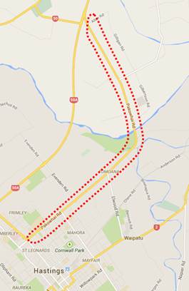
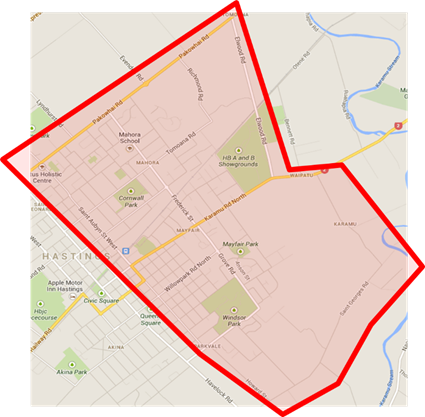
Figure 1 – Extent of Study Area
1.3 The Council is
required to give effect to the purpose of local government as prescribed by
Section 10 of the Local Government Act 2002. That purpose is to meet the
current and future needs of communities for good quality local infrastructure,
local public services, and performance of regulatory functions in a way that is
most cost–effective for households and businesses. Good quality means
infrastructure, services and performance that are efficient and effective and
appropriate to present and anticipated future circumstances.
1.4 The objective of this decision relevant to the purpose of Local
Government is to provide good quality infrastructure that is safe, affordable,
integrated, accessible, efficient, and effective in meeting the needs of
present and anticipated future circumstances.
1.5 This report
concludes by recommending:
· That
the report of the Strategic Transportation Engineer titled “Hastings
North Eastern Area Wide and Pakowhai Road Corridor Management Plan” dated
21/11/2017 be received.
· That Council adopt both Corridor Management Plans for strategic
direction.
· That Council consider recommendations of both
Corridor Management Plans as the preferred solutions for the network allowing
for refinement during subsequent modelling and design in the Thirty Year
Infrastructure Strategy and Long Term Plan 2018-28 process.
2.0 BACKGROUND
2.1 A series of
corridor studies have been identified in the LTP to investigate short and long
term interventions on Council’s strategic corridors.
2.2 These
interventions include but are not limited to road renewal, safety improvements,
walking facilities, cycling facilities, CBD renewals, travel plans, parking
strategic and travel demand management initiatives and the Council’s
flagship ‘model community’ project.
2.3 Council has
previously invested in the development of a Corridor Management Plan on
Havelock Road/Heretaunga Street East and has since started the staged
implementation of the recommendations from that study (shared
cycleway/footpath). The Hastings North Eastern Area Wide CMP and Pakowhai Road
CMP are the subsequent studies of this nature that are completed in recent
years.
2.4 Pakowhai Road was
selected for a CMP as it is one of Hastings key arterial routes for commuter
traffic and freight access. It provides a direct access to the industrial
areas of Whakatu and Tomoana and also provides a strategic link between
Hastings and Napier.
2.5 The Hastings
North Eastern Area Wide CMP was progressed primarily to consider similar issues
in relation to St Aubyn Street and Karamu Road whilst also accounting for key
access requirements in to the Tomoana industrial area and commercial retail
areas on Karamu Road/St Aubyn Street.
2.6 The CMP’s
are intended to assist in achieving a highly efficient freight route connecting
the Whakatu-Tomoana industrial and Karamu - St Aubyn clusters to the
Hawkes Bay Expressway (HB Expressway), while also making provision for
attractive multi-modal transportation choice, particularly in the urban area.
2.7 The scope of the
CMP’s was to evaluate the performance of the existing network in terms of
development, access (private and road), parking demands, alternative transport facilities,
people and freight movement and safety.
2.8 The outcome of
the study is the development of a CMP which, when implemented, will provide
adequate infrastructure for the expected future transportation demands of the
network. This includes maintaining road safety, provision for increased freight
traffic on the route and enhanced walking, cycling, and also public transport
facilities for the period to 2046.
2.9 The process
adopted for the CMP can be broadly summarised as follows:
· Review of historic transportation projects and studies relevant to
area;
· Review of current and future land-use projections for surrounding
area;
· Assessment of current and future traffic demands (volumes) for the
network;
· Assessment of road safety issues and concerns;
· Data collection through stakeholders and public engagement and
consultation;
· Identification of desired corridor objectives for key routes within
the study area; and
· Development of project alternatives to address identified problems
and achieve desired objectives.
3.0 CURRENT SITUATION
3.1 As identified in paragraph
2.4 and 2.5, the study area was selected based on the number of strategically
important routes within the area and the anticipated land-use and transport
changes impacting the network over the coming years.
3.2 The predominant
issues identified currently and in near future include traffic delays and
queuing, road safety, pedestrian and cycle connectivity and access to
development areas.
3.3 With respect to
road safety, the analysis undertaken details a number of locations with high
incident crash records including:
· Frederick Street/Karamu Road/Grove Road;
· Tomoana Road/St Aubyn Street;
· Nelson Street/St Aubyn Street;
· Nelson Street/Queen Street;
· St Aubyn Street/Willowpark Road;
· Fitzroy Avenue/Nelson Street;
· Fitzroy Avenue/Tomoana Road;
· Pakowhai Road/Elwood Road;
· Pakowhai Road/Richmond Road;
· Pakowhai Road/Ruahapia Road;
· Pakowhai Road/Farndon Road.
3.4 The
traffic operational performance of the network is shown to deteriorate in
future years as development intensifies throughout the district. Figures
2 and 3, detail the likely link and intersection issues during 2026 morning and
evening peak hours especially along following areas of network:
· Ruahapia Road (will be resolved on completion of Whakatu Arterial
Link);
· Elwood Road/Pakowhai Road;
· Richmond Road/Pakowhai Road
· St Aubyn Street (near Karamu Road)
· Pakowhai Road/St Aubyn Street
· Karamu Road/Frederick Street
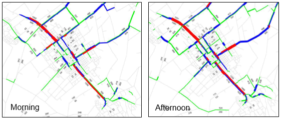
Figure 2 - Link Level of Service Plots (red being poor)
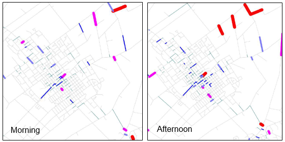
Figure 3 - Intersection Level of Service Plots (red being poor)
3.5 Freight movements
within the study area are also observed high on a number of routes and in some
instances they present a conflict with adjoining land uses (i.e. residential
and schools) and other vulnerable road users (pedestrians/cyclists etc.).
Figure 4 identifies the current freight routes within the residential area of
the study extents.
Figure 4 - Freight Movements in residential area
3.6 Cycling
provision is relatively good within the study area although a number of key and
strategic linkages are currently of a poor and inconsistent quality (or are
missing). Additional gaps in the cycle network are further summarised in Figure
5.
Figure 5 - Cycle connectivity issues
4.0 INTERVENTIONS
4.1 Both CMP
identified a number of individual projects which would address the identified
issues and will assist in achieving the long term aspirations for the network.
A number of these projects were also identified through previous strategic
studies, such as Whakatu Arterial Link (WAL), but are included within this
study for completeness, given impacts anticipated along Pakowhai Road and the
wider network resulting from these projects.
4.2 In general terms
the interventions were thoroughly assessed using the Heretaunga Plains
Transport Study (HPTS) Traffic Model (for future years) and through an economic
evaluation.
4.3 The proposed
interventions can be summarised in three categories as follows:
· Strategic interventions – large projects such as the Whakatu
Arterial Link (WAL) and North Eastern Connector (NEC).
· Corridor Interventions – operational, safety and amenity
proposals for whole corridors within the study area.
· Intersection Interventions – specific intersection projects
aimed at improving operation, safety and connectivity.
4.4 Strategic
Interventions
4.4.1 The strategic transportation
projects which will impact the study area include the Pakowhai Road/Links
Road/Expressway intersection enhancements, the WAL project and the NEC project.
4.4.2 Each of these projects
highlighted have previously been assessed within the HPTS and are shown to
deliver significant economic benefits for the region and will outweigh
considerably the associated implementation costs. The WAL and the Pakowhai Road
/Links /Expressway projects are already well advanced with construction have
already commenced on WAL project.
4.4.3 The NEC project was re-evaluated
through the Hastings North Eastern Area Wide CMP to confirm the anticipated
benefits are still appropriate. Given the WAL is at construction stage
now the CMP considered and assessed whether the benefits of an additional link
road (NEC) will be warranted.
4.4.4 This
assessment considered 2 route options as follows:
Alternative
1 – Link road from Pakowhai Road to Karamu Road
Alternative
2 – Link road from Pakowhai Road to Tomoana Road
4.4.5 Both alternatives are proposed
to commence at the Hawke’s Bay Expressway (SH50A) and will utilise the
existing Evenden Road corridor to the roundabout at Pakowhai Road. A new link
is proposed from Pakowhai Road to Tomoana Road. Alternative 1 will continue
south along Coventry Road and will require a new rail crossing with the
remainder of the alignment running parallel to Kennilworth Road through the
A&P Showground with a new roundabout at the intersection with Karamu Road.
Alternative 1 will require the closure of Elwood Road at the railway line as NZ
Rail have indicated in past that they will not accept an additional rails
crossing so closely allocated.
4.4.6 The economic assessments (as
summarised in Table 1) confirmed that constructing either of these alternatives
will likely deliver significant benefits to the region. Alternative 1 despite
being the costliest alternative, is predicted to have the highest benefits over
span of 40 years and will likely provide a better economically viable
alternative.
Table
1 – Economic Assessment Summary
|
ITEM
|
ALTERNATIVE 1
|
ALTERNATIVE 2
|
|
Total Net Benefits
(TTS, VOC)
|
$31.8 M
|
$16.6 M
|
|
Total PV Costs
|
$6.4 M
|
$4.1 M
|
|
BCR
|
5.0
|
4.0
|
4.4.7 The majority of benefits for
both alternatives will come from travel time and vehicle operating cost savings,
as the project will provide a shortest and quickest link from the expressway to
surrounding industrial areas. Moreover, Alternative 1 that connects to Karamu
Road, is predicted to be more effective at shifting through traffic onto the
NEC from local areas with nearly twice travel time and vehicle operating cost
savings when compared to Alternative 2.
4.4.8 The present value of Alternative
2 is estimated to nearly $4.1M and will provide a BCR of 4.0. However,
Alternative 2 will result in discharging the re-routed traffic on Tomoana Rd
(and Frederick Street) Corridor that will likely experience additional traffic
levels including industrial traffic, on nearby residential areas with increased
safety risks and ultimately result in reduce socio-economic values.
Figure 6 –
Strategic Interventions - NEC
4.4.9 Should
the NEC scheme not proceed, there would be a requirement to invest in
additional corridor and intersection solutions especially on Elwood Road,
Richmond Road, Frederick Street and St Aubyn Street. Furthermore, if either
alternatives are not proceeded, then it will increase traffic levels (including
industrial) on residential areas that will increase safety risks and will
dampen socio-economic values of community.
4.4.10 The
recommended solution from the 2018-21 Long Term Plan Workshop is to update traffic
models and investigate most effective solution over next three years, informing
2021-24 Long Term Plan and consider interim safety works.
4.5 Corridor
Interventions
4.5.1 These
interventions include a number of individual projects which address current and
future operational, safety and connectivity issues along the key corridors
within the study area (Pakowhai Road, Karamu Road, Frederick Street and St
Aubyn Street).
4.5.2 Some
of the proposed interventions have already progressed (in part) and represent
the desired long term solutions for each location. The timeframe for
delivery of these enhancements is not set and will extend over many years (and
perhaps decades) and as such the proposed treatments should be considered a
conceptual aspiration which will be refined and confirmed at the time of
implementation.
4.5.3 It
is predicted that a section of Pakowhai Road between Stortford Lodge and St
Aubyn Street will operate at capacity during both peaks in future years (i.e. after
2030) and will result in longer queues and significant intersection delays. To
mitigate this capacity issue in future years, an additional northbound lane for
this section on Pakowhai Rd is proposed. A flush hatched median is also
proposed to improve access and egress from adjacent properties and a shared
footway/cycleway is also included to facilitate better cycle
connectivity.
Figure 8 - Typical cross-section proposed on Pakowhai Rd between Stortford Lodge and St Aubyn Street
4.5.4 Between
St Aubyn Street and Evenden Road an on-road cycleway and daytime
‘clearways’ is proposed in medium term. This involves removing car
parking on road during daytime to facilitate enhanced cycle provision whilst
accommodating a flush central median aimed at improving access to and from
adjacent properties. Given the implications on car parking and other conflicts
a significant consultation strategy is required prior to progressing this
scheme any further.
4.5.5 After
the Lyndhurst Road Developments, it is envisaged that some form of improvements
will be required for the Pakowhai Road/Lyndhurst Road intersection.
Figure 9 - Typical cross-section proposed on Pakowhai Rd between St
Aubyn Street to Evenden Road
4.5.6 An
improved cycle facility between Evenden Road and Chesterhope Bridge on Pakowhai
Rd, is also proposed which will likely connect safely with the Chesterhope
Bridge clip-on project. This link will provide a direct route from Pakowhai
Country Park (and existing HB trails) to Hastings CBD and beyond. A
future cycling link from Chesterhope Bridge to Napier (via Gilbertson Road and
Brookfields Road) is also proposed. This work is currently under implementation
as part of the Urban Cycleway Programme 2015-18.
Figure 10 - Typical cross-section proposed on Pakowhai Rd between
Evenden Road and Chesterhope Bridge
4.5.7 The
provision of a pedestrian/cycle clip-on structure on Chesterhope Bridge to
resolve the connectivity and safety issues associated to this narrow bridge was
identified in the study and is already completed.
4.5.8 Enhanced
pedestrian crossing provision and bus stop infrastructure within the Pakowhai
Village, supported by amenity interventions at this location to achieve a gated
threshold is already completed.
4.5.9 Further
interventions are proposed along Pakowhai Road including a flush central median
through the rural section of the route supported by roadside guard rail at
roadside hazard locations (large open drains etc.).
Figure 11 - Typical cross-section proposed on Pakowhai Rd between
Chesterhope Bridge and Pakowhai Village
4.5.10 Following the completion of the NEC, traffic
volumes and heavy vehicle movements along Frederick Street are predicted to
reduce considerably. This will provide opportunity to create an improved
streetscape and will enhance current cycle connectivity along this route. This
opportunity is depicted in Figure 12.
Figure 12 - Typical cross-section and measures proposed for
Frederick Street
4.5.11 St Aubyn Street will continue to provide a key traffic function in
the future and a route solution that balances high traffic volumes with quality
walking and cycling provision is proposed as shown in Figure 13.
 Figure 13
- Typical cross-section and measures proposed for St Aubyn Street Residential
Section
Figure 13
- Typical cross-section and measures proposed for St Aubyn Street Residential
Section
4.5.12 Improving
the cycle linkages through the study area are critical to achieving the long
term aspirations of Council and new and improved cycle facilities on Caroline
Road (or rail corridor), Willowpark Road and Collinge Road are also identified
as future projects.
4.6 Intersection
Interventions
4.6.1 Both
CMPs identify number of intersections that will require considerable
improvements to address current and future operation as well as safety issues.
There are no proposed works at the Richmond Road/Pakowhai Road intersection and
the Elwood Road/Pakowhai Road intersection on the basis that the NEC link will
be provided, however if the NEC does not proceed then it would be necessary to
propose considerable improvements at both intersections including the Frederick
Street/Pakowhai Road intersection.
4.6.2 Safety
enhancements at the Farndon Road/Pakowhai Road intersection are proposed to
resolve the current issues associated with right turning vehicles from Farndon
Road. This work will be delivered through the WAL.
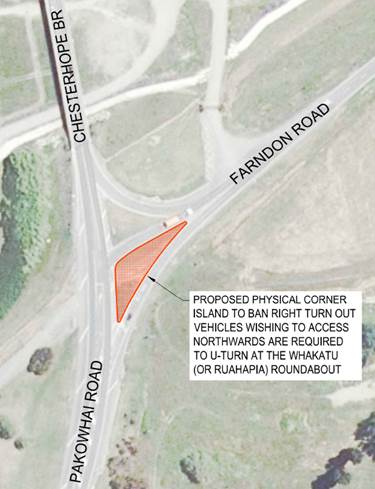
Figure 15 - Farndon/Pakowhai Intersection Improvement
4.6.3 The
signalised intersection at St Aubyn Street/Frimley Avenue/Pakowhai Road will
experience increased delays and queuing in future years requiring an improved
design at this location. A number of layouts are investigated within the
CMP for consideration during the design stage.
Figure 16 – Proposed options at the St Aubyn Street/Pakowhai
Road Intersection
4.6.4 As
development in Havelock North continues to grow and with an expected change in
traffic routing following completion of the WAL and NEC projects (i.e. after
2026), it may be necessary to consider intersection improvements at St Georges
Road/SH2.
Figure 17 - Proposed improvement at the St Georges Road/SH2
intersection
4.6.5 It
is envisaged that traffic levels on the St Aubyn Street/Windsor Ave will likely
increase considerably in future years (especially after 2026) that an
intersection upgrade will be required to facilitate safe and efficient movement
of all traffic.
Figure 18 - St Aubyn Street/Windsor Avenue Solution
4.6.6 The
Hastings Street/St Aubyn Street intersection is also predicted to experience
increased traffic delays during peak hours in future years. Following options
is investigated that will likely improve traffic delays and will likely enhance
pedestrian connectivity across St Aubyn Street.
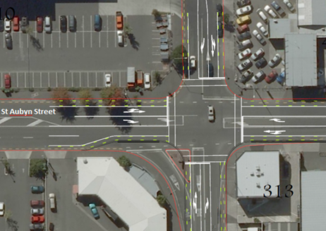
Figure 19 - St Aubyn Street/Hastings Street Solution
4.6.7 A
number of smaller scale interventions are also proposed at the Frederick
Street/Tomoana Road intersection, the St Aubyn Street/Karamu Road intersection
and the Pakowhai Road/Lyndhurst Road intersection. These works will likely
include improvements to existing signal staging, enhanced pedestrian and cycle
provision and road safety improvements.
5.0 SIGNIFICANCE
AND ENGAGEMENT
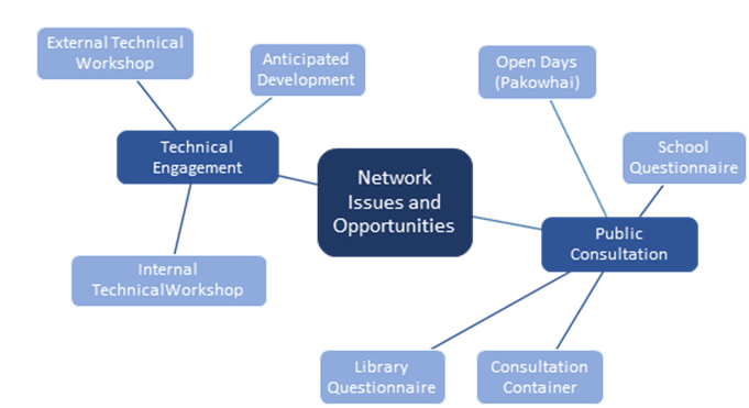
5.1 The
involved level of consultation was adopted (in accordance with guideline set
out in Council’s significant and engagement policy) for both CMPs. A
range of consultation and stakeholder engagement was completed including
meeting with stakeholders and consultation with general public. A number of
different approaches were adopted for each as detailed in the diagram below.
5.2 Approximately
30 individuals attended the open days (for Pakowhai Road CMP) and the feedback
received provided an overview of what is important to the community and where
HDC should concentrate their efforts to achieve the best outcomes for the
corridor. Some of this feedback is presented below.
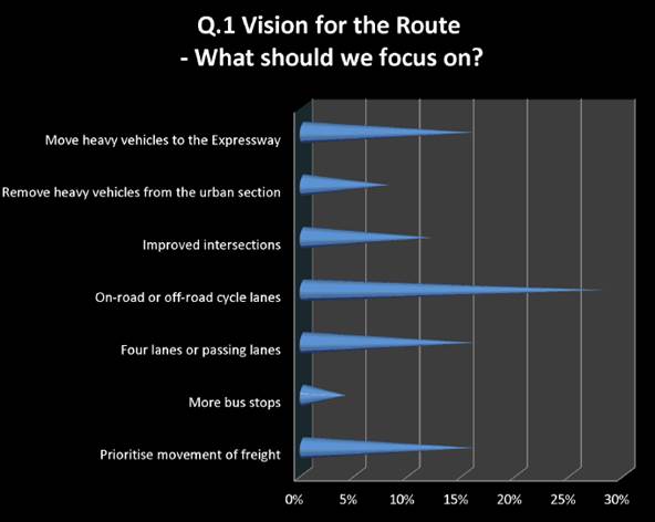
Figure 20 - Route Priorities (Consultation Feedback)
The provision of
cycle facilities was identified as a key priority for the route.
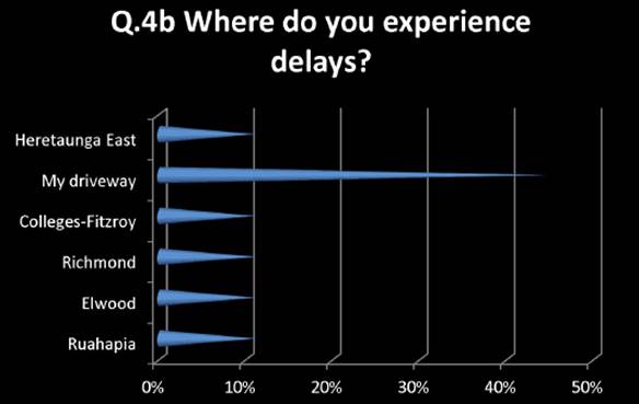
Figure 21 - Route delays (Consultation feedback)
Residential property
access was identified as a key issue for the local community.
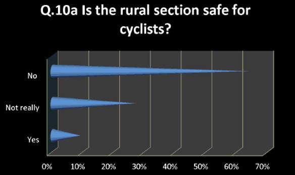
Figure 22 - Rural
section cycle safety (Consultation feedback)
Cycle safety of the
rural section was raised as a specific concern.
5.3 Questionnaires
were returned by 8 schools within the study area which highlighted specific
barriers and concerns relating to road safety, walking and cycling and parent
drop-off.
5.4 For
the area wide study a community consultation day was undertaken in the Hastings
CBD. Comments were received from approximately 100 people throughout the
day which included identification of issues such as traffic operation, road
safety, pedestrian and cycle connectivity and amenity.
5.5 Clearly
the consultation completed to date targeted the objectives of the CMP and as
such information obtained was used to develop intervention strategies for the
network. The project team developed a number of project outcomes which
best address the community concerns raised whilst achieving the long term
strategic objectives for the network.
5.6 These
options were informed by the consultation undertaken, national and local best
practice guidance and technical expertise input.
5.7 To
progress these interventions in to physical measures on site it is necessary to
complete additional consultation and engagement with stakeholders and the local
community. The next stage of consultation will be project specific and
will align with the standard consultation processes adopted by HDC when
delivering new capital project works on the roading network.
6.0 ASSESSMENT
OF OPTIONS
6.1 There
are a number of decisions which Council could make with regards to this report
as follows:
· Option
1 - Adopt the plans and accept the recommendations of this report;
· Option
2 Adopt the plans and accept the recommendations of this report with changes;
and
· Option
3 - Do not adopt the plans reject the recommendations of this report.
6.2 The
plans have been developed following extensive public and stakeholder
consultation and are supported by detailed modelling and engineering
assessments.
6.3 Any
changes to the plans would require the consultation to be revisited and would
likely require additional assessments and modelling to ensure the desired
objectives are still achieved. Whilst it is expected the exact detail of
each project will refine during future stages of each project (affected party
consultation, detailed design etc.), all proposals are developed to identify identified
issues and also to accommodate the likely future transport demands and they
provide a very robust direction for Council.
6.4 Not
adopting both plans as detailed would present a risk to the future network
performance within the study area and could hamper development growth
opportunities within the district.
6.5 Corridor
Assessment interventions -
6.5.1 All
interventions were reviewed against a list of desired outcomes for the
project. These can be broadly summarised as follows:
|
Transport
|
Safety
Cycle promotion
Traffic operation
Sustainable transport
Parking
Connectivity
|
|
Amenity
|
Local ownership
Sense of place
Personal safety and security
Diversity and choice
Create and vibrant
|
|
Project Objectives
|
Future proofing of corridor
Integrated land-use and transport
|
|
Strategic Objectives
|
Transport networks integrated with
land-use
Neighbourhoods designed for walking
Accessible public transport options
Moving community away from car
Less dependence on non-renewables
Smart ways to move goods and people
Less waste
Encourages economic opportunity through
sustainable practices
|
6.5.2 All
proposed works align well with these objectives.
6.6 Economic
assessments have also been undertaken on all intervention projects with
BCR’s ranging from 1.1 to 11. Whilst a number of the projects will
be progressed as stand-alone solutions, it is also expected that many proposed
interventions will likely be delivered as part of wider project. For
example, intersection enhancements may be aligned with planned maintenance works
to reduce user disruption and minimise costs.
6.7 From
the assessments completed it is clear that the proposed projects will deliver
benefits that will outweigh the associated implementation costs. There is
a clear need for the proposed solutions (either now or in the future) and the
delivery of these will result in enhanced safety, operation, efficiency,
amenity and health.
7.0 PREFERRED
OPTION/S AND REASONS
7.1 Option
1 with a staged implementation programme as explained in Table 2, is
recommended as the preferred option.
7.2 Given
the long implementation timeframe for a number of the projects it is
anticipated that the specifics of the project will likely change based on
further scrutiny and consultation at that time.
7.3 A
number of the projects identified in the studies have already commenced and/or
have been implemented on site within the last couple of years. For
example, the Chesterhope Bridge cycle clip on and the rural flush median on
Pakowhai Road between HB Expressway and Brookfield Road has been completed and
significant lengths of guard rail have also been implemented along the
route. In addition, the intersection improvements at the Frederick Street/Karamu
Road intersection have been completed.
7.4 Furthermore,
a number of projects identified in the studies are well progressed including
cycleway provision along Pakowhai Road between Evenden Road and the Chesterhope
Bridge, the Ruahapia Road and Farndon Road intersections with Pakowhai Rd are
included within the WAL project and will be delivered over next 2 years.
Table
2 – Summary of recommended work programme list
|
Location
|
Year
|
|
Frederick Street/Karamu
Road - Completed
|
2015/2016
|
|
Pakowhai Road –
off road cycleway (inc clip-on) - Completed
|
2016/2018
|
|
Karamu Road/St Aubyn
Street
|
2017/2018
|
|
Farndon Rd intersection
improvements
|
2017/2018
|
|
Willowpark Road/St Aubyn
Street
|
2018/2019
|
|
Caroline Road/Rail
Corridor and Frederick Street Crossing
|
2018/2019
|
|
North Eastern Connector
(or the most effective solution)
|
2018 +
|
|
Willowpark Road Cycleway
|
2018 +
|
|
Lyndhurst Rd/Pakowhai Rd
(based on development)
|
2019 +
|
|
St Aubyn Street
(Hastings St to Warren St)
|
2019/2020
|
|
Kenilworth Road Cycleway
|
2019/2020
|
|
Tomoana Road Cycleway
|
2020/2021
|
|
Frederick Street/Tomoana
Road
|
2020/2021
|
|
Rural off-road path
extension to Pakowhai Village
|
2021 +
|
|
Collinge Road Cycleway
|
2022/2023
|
|
Tomoana Road/St Aubyn
Street
|
2023/2024
|
|
Pakowhai Rd Kea Crossing
Upgrades with Signals
|
2023/2025
|
|
St Aubyn Street/Pakowhai
Road Signal improvements
|
2025/2026
|
|
St Georges Road/SH2
intersection improvement
|
2026 +
|
|
Pakowhai Road Flush
median - Completed
|
2026 +
|
|
Pakowhai Rd additional
northbound lane (Omahu – St Aubyn)
|
2036 +
|
|
Karamu Road Urban Design
Upgrade
|
2016-2046
|
|
Windsor Avenue/St Aubyn
Street
|
2042/2043
|
|
Frederick Street Urban
Upgrades
|
2045 +
|
|
St Aubyn Street Urban
Upgrades
|
2045 +
|
(Note – All
individual programmes will be detailed investigated including modelling prior
to implementation)
|
8.0 RECOMMENDATIONS AND REASONS
A) That the
report of the Strategic Transportation Engineer titled “Hastings
North Eastern Area Wide and Pakowhai Road Corridor Management Plan”
dated 21/11/2017 be received.
B) That the Council adopt both the Hastings North Eastern Area Wide
and Pakowhai Road Corridor Management Plans as its strategic direction.
C) That the Council consider recommendations of the Corridor
Management Plan (CMP) reports as the initial preferred solutions for the
network in the Thirty Year Infrastructure Strategy and Long Term Plan 2018/28
process allowing for refinement during subsequent modelling and design.
With the reasons for this decision
being that the objective of the decision will contribute to Council’s
strategic objectives:
· Develop transport networks integrated with land use
· Neighbourhoods’ designed for walking and cycling
· Accessible public transport options
· Moving the community away from car dependency
· Increased use of renewable resources
· Smart ways to move goods and people
By:
· Providing transport networks which support its land use
environment
· Providing facilities to the standard where people could use
walking and cycling as an obvious choice
· Developing public transport to the point where it becomes an
obvious choice of transport
· Providing alternative transport choices to an equivalent or better
level than private car usage
· Supporting travel demand management measures
· Investigating and developing alternatives.
|
Attachments:
There are no attachments
for this report.
REPORT TO: Works
and Services Committee
MEETING DATE: Tuesday 21
November 2017
FROM: Project Manager
John
Wright
SUBJECT: Whakatu
Arterial Link (WAL) Update
1.0 SUMMARY
1.1 The purpose of this report is to update/inform the Committee/
Council on construction progress, the financial status and potential risks
associated with the Whakatu Arterial Link.
1.2 The roading contract period is from 24th November 2016 to
24th November 2018. An additional 54 workings days’ time
extension has been approved for wet weather and its consequential effect on
construction. Notwithstanding the time extensions there is a high level
of confidence that the WAL will be completed by December 2018 or earlier,
weather permitting.
1.3 The WAL project budget is $25.6 million which includes design,
investigation, planning, property purchase, construction and a contingency of
$1.75 million for the expenditure of approved contract variations.
1.4 The WAL project is tracking on budget.
2.0 BACKGROUND
2.1 The WAL project
involves the construction of a new arterial from the Napier Road / SH2
intersection to Pakowhai Road. Work includes the construction of a two
lane arterial and three new roundabouts at SH2, Whakatu Road and Pakowhai
Road. Higgins Contractors have been awarded this contract for the sum of
$9,951,054.48 excluding GST.
2.2 A new precast
concrete bridge is required at the Karamu Stream crossing adjacent to the
Nimon’s bus depot. Concrete Structures Ltd. have been awarded this
bridge contract for the sum of $1,784,777.00 excluding GST
2.3 The existing
Farmland’s Fuel Stop requires relocation as a result of the new
“peanut” roundabout on Whakatu Road. The new fuel stop moved
70m to the west of the Nimon’s site. Gemco Construction were
awarded this contract for the sum of $696,113.04 excluding GST.
2.4 The WAL project
has had a significant effect on existing service authority
infrastructure. Council has been working with Unison (Power), Chorus
(Telecom) and Nova Energy (gas) to ensure services are relocated, replaced or
protected as required.
2.5 The WAL project
has had a significant effect on private and commercial properties.
Enabling works are being carried out to mitigate the impact and effects that
land purchase has had on these properties. Enabling works include
fencing, headland tracks, irrigation, orchard removal, shelter belts, windmill
relocations, new wells, frost protection, driveways etc.
3.0 CURRENT SITUATION
3.1 Resource Consent
conditions require all contractors to comply with the approved environmental
management plans in respect of stormwater, erosion, sediment, noise, vibration
and dust control. HB Regional Council and Hastings District Councils
Environmental Compliance Managers are satisfied that the environmental
compliance is being achieved by all contractors. Dust controls remains
the biggest challenge in windy conditions.
3.2 All contractors
have established robust safety plans with an active culture of identifying
potential safety hazards and implementing remedial work to minimise or
eliminate probable hazards. There has been one minor injury accident on
the WAL project (hitting thumb nail with hammer).
3.3 Gemco Contractors
completed the relocation of the Farmlands Fuel Stop on 30 June 2017.
Farmlands are pleased with the completed layout and operation of the new fuel
pumps.
3.4 Higgins
Contractors are providing sufficient resources to complete the WAL project well
within their allocated time adjusted contract period, with an estimated
completion date of December 2018. Their quality of work meets
specification and they provide all necessary and compliant test results from an
independent consultant, Opus Laboratories.
3.5 The state highway
roundabout is substantially complete with remaining items of work to include
Pilcher Road sealing, Mangateretere School frontage, gardens, grassing and
finish footpaths. Higgins have been requested to complete this work at
their earliest convenience.
3.6 Earthworks have
commenced in the Whakatu Road area on the new “peanut roundabout”
and T&G carpark. Work is programmed to be substantially complete in
February 2018. All other earthworks on “greenfields” sites
can now continue that the ground conditions are drier but subject to
restrictions on vehicle movements to maintain dust control around sensitive
orchard locations.
3.7 The Karamu Stream
realignment was completed in August 2017.
3.8 Concrete
Structures Ltd have completed 72% of the new Karamu Stream Bridge. Piles,
abutments and bridge deck beams are now in place. Work continues on
concrete barrier and handrail installation with an estimated completion date
for the bridge in early December 2017.
3.9 Service
Authorities have met the required construction timeframes to ensure that there
are no delays to Higgins Contractors. Unison have completed all works on
the WAL project. Chorus have some remaining work in Pakowhai Road and
Nova Energy (Gas) has a gas changeover to a new line in Whakatu Road.
3.10 Enabling works to
private property is substantially complete. The main item of work to
complete is the T&G carpark and entrance way.
3.11 Kiwi Rail are
programmed to install signal and barrier arms at the new rail level crossing in
March 2018.
4.0 PROJECT RISKS
4.1 There are a
number of potential risks to the project that have been identified and
estimated costs have been allocated to the budget. The potential project
risks are:
· Contract Documentation – Schedule of Quantities:
Risk
Level = Moderate
This
is a “measure and value” contract meaning payment is made to the
contractor based on actual work completed. If the tendered schedule of
quantities is inaccurate or has omissions, this will result in additional costs
(variations). Variations to date have been significant but it is
anticipated that all known and predicted costs have been budgeted for.
· Cost Fluctuations:
Risk
Level = High
This
contract allows for cost fluctuations to be applied for after 12 months.
The greatest risk is the fluctuation of bitumen prices as this is expensive and
will affect all the remaining sealing works. Prices could vary +/-
$150,000 or more and the drop in the NZ dollar value increases this risk.
This is the only risk that has not been budgeted for due to the unpredictable
nature of fluctuations.
· Dust:
Risk
Level = High
Control
of dust during construction to avoid excessive accumulation on sensitive land
areas including orchards, pack houses and fruit processing businesses is a key
priority. Dust mitigation includes avoiding construction in areas during
sensitive orchard flowering and harvesting periods, using water cards and
irrigation or applying emulsions to earthworks in sensitive areas. The
control of dust during windy periods can be difficult.
5.0 SIGNIFICANCE AND ENGAGEMENT
5.1 The WAL has been
identified as a key strategic project within the Council’s Long Term Plan
2015/25 and the Regional Land Transport Programme 2015/25.
5.2 The project has
undergone extensive consultation from its inception with the Whakatu Enquiry by
Design process which consulted with Industry, Iwi, landowners, transport
industry representatives and associations, and government agencies.
5.3 The required
budget is already included in the Annual Plan and as such the consultation and
engagement requirements have been addressed.
6.0 FINANCE POSITION
6.1 The project
budget is $25.6 million with this value including at $1.75 million contingency for
the expenditure of contract variations.
6.2 Higgins
contractors have completed 45% of the roading physical works. Financial
progress to 30 Sept 17 is as follows:
|
|
Completed
|
Remaining
|
Total
|
|
Scheduled
Work
|
$4,433,755
|
$5,517,299
|
$9,951,054
|
|
Variations
|
$479,744
|
$780,646
|
$1,260,390
|
6.3 Concrete
Structures have completed 72% of the Karamu Stream Bridge. Financial
progress to 30 Sept 17 is as follows:
|
|
Completed
|
Remaining
|
Total
|
|
Scheduled
Work
|
$1,291,177
|
$493,600
|
$1,784,777
|
|
Variations
|
$104,855
|
$16,195
|
$121,050
|
6.4 Gemco
Construction have completed 100% of the Farmlands Fuel Stop. Financial
progress to 30 Sept 17 is as follows:
|
|
Completed
|
Remaining
|
Total
|
|
Scheduled
Work
|
$696,113
|
$0
|
$696,113
|
|
Variations
|
$30,518
|
$0
|
$30,518
|
6.5 The estimated
total variation cost to the completion of the WAL project is $1,411,958.
This is $338,042 under the allocated contingency budget of $1,750,000.
The balance of the contingency ($338,042) has been spent or committed on
enabling works, service authority work, consultation fees, archaeologists, HBRC
fees and legalisation costs etc.
6.6 The WAL project
is tracking on budget.
6.7 The budget
contains a $75,000 contingency for unknown variations as of 30 Sept 17.
6.8 The budget is
based on estimated property reimbursement costs of $762,000 from the sale
proceeds of Hawea Park, the Hayley property and the Fulfords corner.
6.9 All prices shown
in this report are exclusive of GST.
|
7.0 RECOMMENDATIONS
AND REASONS
A) That the
report of the Project Manager titled “Whakatu Arterial
Link (WAL) Update ” dated 21/11/2017 be received.
With the reasons for this decision
being that the objective of the decision will contribute to meeting the
current and future needs of communities for good quality local infrastructure.
|
Attachments:
There are no
attachments for this report.
REPORT TO: Works
and Services Committee
MEETING DATE: Tuesday 21
November 2017
FROM: Group Manager: Asset Management
Craig
Thew
SUBJECT: Asset
Management Group Project and Activities Update as at September 2017
1.0 SUMMARY
1.1 The purpose of this report is to update the Committee on progress
with projects managed by the Asset Management Group and
other activities, as well as strategies the Group has been working on during
the 2017/2018 financial year. Financial details are reported as part of
the separate quarterly financial report to the Finance and Monitoring Committee
ultimately in the Annual Report.
1.2 The Council is required to give effect to the purpose of local
government as prescribed by Section 10 of the Local Government Act 2002. That
purpose is to meet the current and future needs of communities for good quality
local infrastructure, local public services, and performance of regulatory
functions in a way that is most cost–effective for households and
businesses. Good quality means infrastructure, services and performance that
are efficient and effective and appropriate to present and anticipated future
circumstances.
1.3 This report
concludes by recommending that the report of the Group Manager, Asset
Management be received.
2.0 UPDATE ON KEY
PROJECTS
2.1 A Schedule of
Contracts Let is attached as Attachment 1 and Attachment 2.
2.2 The Asset
Management Projects Status Report is attached as Attachment 3.
2.3 A more detailed
record of Major Projects that are being delivered across Council is included in
a separate report that forms part of this Committee’s agenda.
3.0 WASTE AND DATA
Solid Waste
3.1 Omarunui
Landfill: Revenue (excluding levy and ETS) at the landfill as at 30th
Sept 2017 was $557,426 more than expected (against budget) due to final revenue
for forest harvest that was unbudgeted in 2017/18 ($439,046). The
estimated volume of waste for the 2017/18 year is 75,000 tonnes. After
the first 3 months of the 2017/18 year the tonnes of refuse received was 6.4%
more than expected however the total was 1.1% less than for the same period
last year. It is now anticipated that around 80,000 tonnes of waste will
be disposed of at the site. This would also indicate a possible slowdown
in the recent increases of waste going to landfill. In financial terms
the overall net surplus from operations of $900,437 is $494,088 favourable to
budget. Expenditure is $87,120 above budget due to landfill maintenance
and leachate spend. It is important to note that the figures provided
above include costs and revenue associated with the harvest of the landfill
forest. In particular the impact of the revenue generated by the harvest
has had a significant impact on the revenue budget. Harvesting
operations were completed in September 2017. The
matter concerning the possible replanting of the forest site and the setting up
of a landfill forest reserve is the subject of a separate report to the Omarunui
Refuse Landfill Joint Committee.
3.2 Refuse
Transfer Station: Revenue (including internal recoveries) at the Henderson
Road refuse transfer station is $31,379 below budget. Operational savings
at Henderson Road are $103,832 ahead of budget. Therefore the current YTD
surplus is $72,453. The forecasted End of Financial year position is a
small surplus.
Waste Minimisation
3.3 Waste Planning: The compilation of
documents that complete the joint HDC/NCC Waste Assessment were presented and
received by the Joint Waste Futures Committee on 14 October 2017. This includes
the options table will be included in the draft Waste
Management and Minimisation Plan (WMMP).
3.4 Officers are
currently completing the draft joint WMMP. To assist with the development
of the plan, various external parties have been and will continue to be engaged
for specialist advice as and when required. It is anticipated that the draft
document will be released to the public following the special consultative
procedure early in 2018. Feedback will then be assessed by the Joint
Committee and incorporated into the final document for adoption by 1st
July 2018. Pre consultation focus group meetings will be held in early
November.
3.5 Henderson Road
Recycling Depot Improvements: The asphalted area has been extended
and negotiations are currently underway with the preferred tenderer for the
construction of walkway platform. Once completed, eight Green Bins will be put
in place and all other recycling bins removed. The intended site improvements
will also address existing health and safety concerns relating to traffic flow
as well as leading to servicing efficiencies.
3.6 It is proposed to
use accrued Waste Levy funds to make these improvements. It is expected
this system will be in place in over summer.
3.7 Green Bins
– Rural Recycling: Manco Engineering have constructed 6 further bins
(as allowed for in the supply contract) for the implementation of Maraekakaho
and Henderson Road sites. The existing sites are working well and a total
of 1000 tonnes of recycling was collected over the 2015/16 financial year. Two
bins which were surplus to our immediate requirements were sold to Tasman
District Council for use at Murchison. The HDC has the ability to order
additional bins under the supply contract it has with the manufacturer and it
has been able to do this to assist the Tasman District Council in purchasing
bins to initiate their rural recycling programme.
3.8 Waste Levy
Funds: Council receives waste levy funds from the Ministry for the
Environment (MfE) on a quarterly basis. These funds are accrued into a
reserve and can only be spent on new waste minimisation initiatives. The
reserve currently sits at $899,567. The levy fund has recently funded the
installation of all recycling facilities around the district. Funds have
also been committed to both the Enviroschools, Nourished for Nil and Pare Kore
Programmes to increase community awareness of waste issues. The adoption of the
WMMP will identify new projects and initiatives that meet the fund criteria.
4.0 WATER SERVICES
PROJECTS
4.1 Wastewater
Operations
4.2 Reticulation
System: Wastewater operations activities have
included routine maintenance and repairs of the wastewater reticulation system,
pump stations and the attendance of customer service requests. There have been
no major wastewater service issues during the last quarter.
4.3 East Clive
Wastewater Treatment Plant: The wastewater
treatment plant continues to operate well. Key activities include:
· Routine operations and maintenance activities.
· The domestic screens improvement work is ongoing and approval has
been obtained for the procurement of a new centre-flo band screen. This is
important to ensure very limited amounts of solids pass the screen and enter
the BTFs.
· Improvements and renewals continue to be made to the industrial
milli-screening dewatering system.
· Planning continues with the PLC (Programmable Logic Controller)
system upgrades.
Outfall Consent
Compliance
4.4 Routine quarterly
resource consent sampling and monitoring has been undertaken and the Annual
Compliance Report has been prepared and submitted to HBRC. The plant continues
to operate within the consent conditions. The Annual Open Day will be held on
Saturday the 11 November at the WWTP in East Clive.
Capital Works
Projects
4.5 The following wastewater
projects are underway;
· Outfall Diffuser Renewal: The diffuser renewal project has recently been completed and is in
defects period. The new diffuser is operating well.
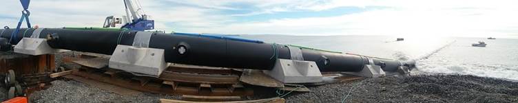
Diffuser Launch
· East Clive Emergency Beach overflow chamber: The emergency beach overflow chamber upgrade design is underway
with construction planned for the fourth quarter 2017/18.
· East Clive Beach Overflow Groyne Rock Wall: The rock wall protecting the East Clive Groyne and beach
overflow chamber has been eroded and weakened over time and during recent
storms the crest and the toe of the wall showed signs of slippage. This damage
was assessed and urgent renewal works were planned, designed and implemented to
ensure the ongoing protection of the beach crest, groyne and overflow
structures. To date the works on the northern side of the groyne have been
largely complete, with only the top end still under construction. The wall on
the southern side of the groyne is being designed and works will commence in
the fourth quarter or early in the next financial year. The northern side cost
estimate is $220,000 with $192,000 spent to date. The southern side costs will
be determined as part of the design phase currently underway.
|

Rockwall Before-dropping
away at top and toe eroded (looking West)
|

Rockwall After-more
effective shallower grade (looking East)
|
· Te Mata Road Sewer Upgrade: The
construction works are progressing, there have been some delays due to the
inclusion of an additional length of water pipeline and related site
constraints/issues. The Contractor has increased resources to expedite the
works programme, however, works will now need to extend into the New Year.
The
majority of the works along Te Mata Road from Karanema Drive to Durham Drive
will be complete prior to Christmas with a discrete portion of work on St Hill
Lane and Te Mata Road up to Hillbrook Place to be completed in the New Year.
The remaining works on St Hill Lane will require further traffic management and
road closure in the New Year.
The
contractor continues to keep the community and those directly affected informed
via radio updates and direct communications.
· Wastewater Renewals: The wastewater
renewal works programme for 2017/18 in conjunction with transportation
priorities includes a section of Windsor Avenue, Ngaio Street and a section of
St Aubyn Street.
· CBD Catchment Renewals Investigations:
Queen Street Service Lane and the wider CBD catchment renewals investigations
are underway and renewal/upgrade options will then be assessed and implemented.
· Rising Mains Investigations: Rising main
condition assessment works and planning is ongoing. This will assist the
prioritisation of rising main renewals and improvement works for the 2018/28
Long Term Plan.
· Park Road Rising Main Upgrade: The
system master planning and design of stage 1 is underway. The staged upgrade
programme has been included in the draft 2018/28 LTP works programme.
· Trunk Sewers: Further condition
investigations are underway on the trunk sewers. This will help to quantify and
prioritise the Trunk Sewer Renewal Programme for the 2018 LTP.
Stormwater
Operations
4.6 Stormwater network operations carried out in the last quarter
included routine maintenance of the piped network, open drains, pump stations
and detention dams. There are still some trees to be broken down and
removed from some drainage reserves, which have not been able to be removed due
to the wet weather and saturated ground.
Stormwater Network
4.7 Site assessment for the James Rochfort and Barnes Place industrial
sites to identify the source of contaminants entering the stormwater network
are underway and due for completion in December 2017. This approach will
be implemented for the Lowes Pit catchment, as required by the resource consent
conditions. An investigation in the Akina area is underway to
establish if there is potential for rain related runoff to enter the wastewater
network, this is commonly referred to as infiltration (water entering a
pipeline via cracks and open joints) and inflow (a direct connection to the
wastewater network). Resident feedback via a recent questionnaire will be
used to target areas for further assessment.
Stormwater
network Consent
4.8 The annual compliance report was submitted to HBRC in the July
project steering group (PSG) meeting. A variation to the consent is being
produced to alter the frequency of routine sediment and water sampling, to
allow for targeted monitoring of the Ruahapia Industrial catchment. It is
proposed to carry out site assessment within this catchment to identify
potential sources on contaminants that may enter the stormwater network and be
discharged into the Ruahapia Stream. A similar approach has been taken
for the smaller Omahu Rd consents (James Rochfort, Barnes Place and Lowes Pit)
and lessons learnt from these investigation will be used to assess the Ruahapia
Industrial catchment.
Capital Works
Projects - That have been programmed for
completion this financial year
4.9 Railway Road
– The Railway Road Stormwater Improvement project has been awarded to
Fulton Hogan who are due to start work on site in mid-November. The
contract is due for completion in May 2018.
4.10 A communications plan
has been developed for work with individual businesses along Railway Road to
minimise the disruption and inconvenience. Council has provided a key
project contact person to maintain contact with the owners to direct queries to
the appropriate staff. To date project staff have met
with the owners of Apple Motor Inn, Angus Hotel, Angus Liquor Store, BP Railway
Rd and staff at the Police Station to understand their business needs during
the construction period. A second meeting to introduce the contractor and
go through the construction programme will be held with the individual business
and an option for a group meeting has also been arranged.
4.11 For health and safety reasons there are portions of Railway Road
which will be subject to a full road closure during the day while the
contractors are excavating and laying pipes. The road closure is to
protect the workers on the road, in the trench, road users and so that
additional traffic loading does not impact on the excavation activities.
The main road closure will be the section of Railway Road in front of the
Hastings Racecourse, which will be closed during daylight working hours and
opened up to limited traffic after hours. Similarly when the contractor
is working in the blocks between Southampton and Eastbourne, one block will be
closed to through traffic and detours in place. Although road closures
will be in place, resident and business traffic will still be able to access
their properties during the works.
Growth
Areas
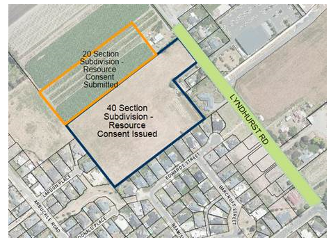
4.12 Lyndhurst Stage 2
Residential - Development of approximately 40
sections is being undertaken by a local developer and resource consent applied
for a further 20 section subdivision on adjacent land. The contract for
the installation of bulk services has been awarded to Fulton Hogan for the
construction of water, wastewater, stormwater and a full road upgrade between
Nottingley Rd and the end of Lyndhurst Rd.
4.13 Irongate Industrial
- The construction of bulk services to the Irongate industrial area is substantially
complete.
4.14 Omahu Industrial - The tender for
the installation of bulk services has been issued and submissions are due back
in mid-December. The contract includes water and wastewater services
installed along a council owned service corridor along the rear of the
industrial zone.
Water Supply
Operations
4.15 Reticulation
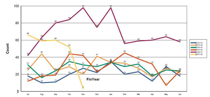
Maintenance – The number of lateral faults has been quite sporadic
over the last couple of months. The graph below shows the variability in
monthly repairs across the network which have been consistently above
historical trends.
4.16 The types of failures
are a mix of copper pipe pinholes but there are a number of faults stemming
from the deterioration of fittings (brass and gun-metal) which is a cause for
concern as many of these are only 15 to 20 years old. We have engaged a
consultant to look at this problem in more detail to ascertain the primary
cause of these failures and to undertake metallurgical analysis of samples to
identify a root cause.
Demand
4.17 Water demand across
all supplies is slowly increasing as we approach the summer season. Current
daily demand is between 35,000,000 and 40,000,000 litres per day which is
typical for this time of year.
4.18 Water Use Monitor
– see graph below:
4.19 Most of the increase
over base consumption is attributable to increased urban irrigation. The
standard water conservation messaging has been prepared and is being
implemented in November as part of our overall summer campaign on water
conservation which is an annual requirement of our resource consent.
4.20 This year we will also
be joining forces with Napier City to deliver an upgraded and more
comprehensive programme that will target both urban and rural water usage. This
will be rolled out over the coming months.
4.21 Brookvale bore 3 will
also be operational this summer to help support Havelock North. This bore is
fully treated with filtration and UV disinfection in place and provides a
consistent base flow which will be used to augment summer peak demand across
the network.
Capital Works
4.22 Heretaunga St
Watermain: This project is due for completion at the beginning of December.
The remaining work consists of the installation of a 150mm watermain inside the
abandoned 200mm steel main and final connections and commissioning.
4.23 Work is being
accelerated to ensure that all site works and reinstatement are practically
complete in time for Xmas.
4.24 Te Mata Rd Water
and Sewer Installation: This project has fallen behind schedule and is unlikely
to be completed prior to Christmas. There have been a number of changes that
have arisen as work has progressed including some re-design to accommodate
additional valves and the relaying of a number of sewer laterals that are
clashing with the watermain drilling alignment.
4.25 Another complication
has arisen in St Hills Lane where the close proximity of the 375mm asbestos
cement watermain has required a review of how the sewer main is to be
constructed in this section. The risk of ground slumping and loss of pipe
support to the critical watermain was deemed to be too great and an alternative
alignment has been settled on.
4.26 While this delay is
frustrating, it now means that St Hills Lane will be reopened to full traffic
and the work will now be undertaken in January of next year.
4.27 The contractor is continuing
to drill and install pipes in Te Mata Rd to ensure that this work is completed
and reinstated before Christmas. There will be one small section (134m) of
sewer main that will be upgraded in the New Year. This needs to remain in place
as it is acting as a by-pass for sewer flows.
Compliance
4.28 The water team are
continuing to advance the Infrastructure Data (ID) management system to provide
enhanced operational compliance and water treatment dashboard reporting. The
system is a cloud based system allowing for access to approved uses from pc,
tablets and phones for reports and online forms.
4.29 The report below is an
example of one of the many reports from Brookvale Bore 3. Key operational
parameters can be viewed together and statistical data is compiled to provide a
quick overview of treatment plant performance. The report below confirms
compliance to the standards and is also directly accessible by the DWA’s
4.30 The ID system
schedules and monitors routine inspections and instrument checks and monitors
compliance within the timeframes required. This then enables simple reports to
be compiled to demonstrate to the Drinking Water Assessors that we have
maintained DW compliance and validated the treatment process.
Water Strategy
4.31 The Hastings Water
Strategy is an ongoing, wide ranging assessment of our current and future water
supply needs.
4.32 This work has been
driven by the need to find a suitable alternative to the Brookvale Bore 3
supply and to ensure that water services to the Hastings, Havelock North and
Flaxmere network are as safe as possible and can support our current and future
predicted needs.
4.33 Of primary importance
is the construction of a 5km, 500mm diameter watermain from St Aubyn St in
Hastings to Karanema Drive in Havelock North. The final alignment is being
confirmed and detailed investigation and design has progressed to the stage
where a tender will soon be advertised.
4.34 In addition to the
watermain, a booster pump station is required to deliver water to the higher
elevations in Havelock North and to maintain reservoir capacity. This booster
pump station enables the more efficient delivery of water into Havelock North
and maintains system pressures into the most elevated areas that have
historically been affected during peak summer demand.
4.35 The issue of the new
watermain and pump station are considered in a later item on the Agenda.
5.0 TRANSPORTATION
Urban Cycleway
Programme
5.1 Pakowhai Road Cycleway Project will
provide an on-street cycle lane on both sides of the road between Evenden Road
and Ruahapia Road. The first stage of construction work between Evenden Road
and Morley Road is complete. The second stage between Morley Road and
Ruahapia Road design work is complete and is construction is scheduled for
January 2018, subject to contract award.
5.2 East Road cycle lane included the
installation of a 2.0m wide lime sand shared pathway. This project is part of
Councils approved Urban Cycleway Programme and school travel plan. Considering
the existing layout of East Road (6.5 m wide carriageway and 100 kph) and the
likely use of the shared pathway by school children, the design included
horizontal and vertical delineators along the pathway. The initial conceptual
design had not progressed an option to pipe the drain and place the path in
this location.
5.2.1 During
the construction, some complaints were received from the community about the
brightness of the delineators used, so working with the ward Councillors it was
agreed to stop further installation and investigate potential alternatives. Two
alternatives were investigated, either replacing the bright markers with standard
white delineators or replace with round wooden bollards and guardrail (similar
to those on Te Mata Peak). The initial estimate received from the Contractor
suggested that both options will to cost approximately $20,000 and $80,000
respectively.
5.2.2 A
site visit was organised with the ward councillors and officers on 30th October
and, as a result, it was determined to retain the existing delineators. It was
also agreed that community response will be monitored and if required, the coloured
delineators will be replaced with white delineators progressively. It was also
agreed to trial a landscape treatment to help create a softer look to the
fence. Initially a mesh netting will be installed and two hardy climbing shrubs
planted in every second bay.
5.3 The following projects have been identified for delivery as part of
the final year of Urban Cycleway Programme:
St Georges
Road: involves continuation of existing bi-directional cycle facility
between Crosses Road and Havelock Road. The project is at the design stage and
will be completed around April 2018.
· Sylvan Road: includes a shared 2.5 m
wide walk and cycle off-road facility along Windsor Park between Grove Road and
Alexandra Street. The project is at the design stage and will be completed around
March 2018
· Southland Drain: includes an off-street
shared facility along the Southland Drain stop banks between Riverslea Road and
St Georges Road. The project is at the design stage and will be completed around
May 2018.
5.4 Based on
NZTA’s guidelines, all Year 2/3 students from Parkvale School and
Year 3/4 students from Frimley School and Havelock North School have completed
the Scooter Safety Programme;
5.5 The Free Bike Check Campaign was successfully run over 6 weeks,
encouraging people to get their bikes checked at four local bike stores in
Hastings and Havelock North in the lead up of summer.
Reconstruction
Projects
5.6 Roadworks on
Karamu road has been completed, a post construction review meeting with
stakeholders is scheduled for 23 November.
5.7 Roadworks
commenced on Maraekakaho road between Southampton and Francis Hicks. These
works include the renewal of the asphalt surface on Maraekakaho road between
Heretaunga and Southampton, including the Southampton/Orchard intersection. As
part of the works the Traffic lights at this intersection are also being
upgraded to LED units.
5.8 Roadworks planned
for Windsor Ave between Ada and Grove Roads are to commence early in 2018.
Maintenance
works
5.9 Resealing in the urban
and rural networks continues. The programme is to be completed by March 2018
5.10 Asphalt works to renew
the road surface is to continue in Havelock CBD with the New World service lane
having its surface renewed.
5.11 A number of
Roundabouts are being resurfaced across the urban network and may cause some disruption
for a short period at each roundabout.
New Works
5.12 Road reconstruction
projects programmed for 2017/18 include:
· Maraekakaho Road: between
Southland Road and Francis Hicks Ave – Works are now underway.
· Pilcher Road: including Lawn Road roundabout and linking up with the
new Whakatu Arterial roundabout on SH2.
· Windsor Avenue: Ada to Grove
– currently provisional depending on price and confirmation of final
routes for new water mains to Havelock North – Programmed to start once
the Maraekakaho Road scheme is complete in the New Year.
· Turamoe Road: – full length
programmed for completion prior to January 2018.
· Waimarama Road: near Craggy Range
entrance.
· Middle Road: near Glengarry intersection
and includes the intersection itself
5.13 Irongate: The
construction of the cul-de-sac at the end of Irongate Road East will be
completed by 8th December 2017. The tender was awarded to
Russell Roads who started on site on 2nd November.
5.14 Road improvements to
Irongate Road and the Maraekakaho Road/Irongate Road intersection are to follow
in 2018/19. The detail designs are underway.
5.15 Lyndhurst Road:
The upgrading of the connection with Percival Road extension is programmed to
start in November 2017. The tender has been awarded to Fulton Hogan along
with the 3waters improvements.
2017/18 Second
Coat and Maintenance Reseals
5.16 The 2017/2018 Resealing programme is well under way with
approximately 25% of the rural reseals complete and 50% of the Urban and Plains
area. Asphaltic concrete resurfacing of Havelock Road between Karanema Drive
and the CBD has also been completed. The Rural area reseals will be completed
before the Christmas holiday break with the Urban and Plains areas completed by
the end of November. There may be a small amount of urban asphaltic concrete
intersection/roundabouts to be completed in January 2018 to work in with other
roading or other contract works.
Bridge Update
Vehicle
Dimension and Mass (VDAM) Rule
5.17 As reported to
previous meetings, the screening of Hasting’s bridge network is complete
with plans to implement 30 restrictions throughout the district.
5.18 As part of the consultation, five rural community meetings were held
throughout the district in Tutira, Rissington, Matapiro, Maraekakaho and
Waimarama.
5.19 Feedback from these meetings will influence the final proposal of
bridge strengthening programme outlined and presented to Council on 29th August
2017.
5.20 The restriction signs are to be implemented and enforced from 1st
December 2017.
6.0 PARKS
Awards
6.1 Council has had a successful month
with the gaining of significant New Zealand wide awards. Not only was
Councillor O’Keefe awarded this year’s Keep New Zealand Beautiful
Local Hero, but Havelock North was also awarded winner the Most Beautiful
Suburb category. Havelock North was lauded as the vibrant heart of
Hawke’s Bay and a ‘must visit’ destination.
6.2 The success of Council’s
recent efforts in revitalising Havelock North was again recognised at this
year’s New Zealand Recreation Association Awards in early November, where
the redevelopment of the Havelock Village Green was given a Merit Award in the
Best Project Category. The judges recognised the extensive consultation
taken in the development of the design and the role of the local community and
partnerships in contributing to the Village Green’s final
success.
6.3 Hastings CBD
Enhancements Project: With Council’s adoption of a suite of CBD
Vibrancy actions, officers are finalising designs for a range of CBD
enhancement projects including a renovated stage, new seating, banners and
streetscape treatments. In addition the plans for the proposed upgrade of
Karamu Road between Eastbourne and St Aubyn Streets are being finalised.
The final plans will be presented to both the Landmarks Advisory Group and
Council, for final approval, prior to tendering and construction.
6.4 Windsor Park
Reserve Management Plan: Council publicly advertised its intention to
prepare a reserve management plan and submissions closed on 8 July.
As a result of LTP workshops and Council’s feedback, the draft plan will
include a staged approach in addressing the key elements of the old netball clubrooms,
hard courts, the stream, skating rink and all other existing park activities.
6.5 Te Mata Park
Management Plan Activation: Progress on the Te Mata Park facilities is now
well underway. Tenders have been let for the two toilet blocks and
visitor shelter, which are already under construction. The car park
tender has also been let with construction to start in
mid-November. The projects are on track for an opening before the
end of February 2018.
6.6 Draft
Cape Coast Reserve Management Plan: This plan, relates to 10 reserves
covering some 66ha within the Haumoana to Clifton coastal strip., has been out
for the statutory 60 day submission period and Some 22 submissions were
received covering 26 points of issue.
6.7 The Reserve Management Plan
Hearings Committee heard submissions on 17 August 2017. The plan will be
brought back to Council for adoption once the outstanding encroachment issue is
resolved by Council. Council’s decisions will then be
integrated into the LTP.
6.8 Lyndhurst Residential Area –
Construction work on the first section of the noise protection bund continues and
is being monitored by staff.
6.9 Spring Planting Programme:
The spring planting programme was completed in the second week of
November. This included 350 trees and 14,000 shrubs.
Keep Hastings
Beautiful
6.10 Council with
Environment Centre organised a clean-up event during Keep New Zealand
Beautiful’ s Clean Up Week with, Flaxmere College Services Academy and
Morgan Educare.
6.11 Chorus Cabinets:
Five more Chorus roadside cabinets have been identified for painting in the
next 12 months. 7 Local artists have submitted a total of 22 art pieces
with another artist to make late submission by 10 November 2017. The Locations
are:
· Intersection of SH50 and Taihape Road – Omahu settlement
· Intersection of Maraekakaho and Raukawa Roads - Bridge Pa settlement
· 135 Maraekakaho Road (Near Fire Station)
· 301 Omahu Road (near HB Hospital)
· Intersection of Napier and Lawn Roads – Mangateretere.
6.12 Façade
Enhancement Scheme: The scheme continues to attract interest from local
building owners. Recently we have focused on attracting building owners
in 100-200 block of Heretaunga Street East. The following table shows the
progress made from the previous meeting:
|
Façade
location
|
Scheme
Status
|
|
112 Nelson Street
South
|
Completed
|
|
103 King Street
|
Completed
|
|
109 Heretaunga St East
|
Colour Consultation near completion
|
|
105 Heretaunga St East
|
Colour Consultation in Progress
|
|
119 Heretaunga St East
|
Colour Consultation in Progress
|
|
111 Heretaunga St East
|
Colour Consultation in Progress
|
|
208 Eastbourne St East/215 Heretaunga St
East
|
Colour
Consultation in Progress
|
|
101
Russell St South
|
Approached
|
|
200
Heretaunga St East
|
Approached
|
|
134
Heretaunga St East
|
Approached
|
6.13 Graffiti:
Incidences of Graffiti offending across the District have taken a sharp
downturn compared with the same time period in the previous year.
Council’s policy of zero tolerance of graffiti and the principle of
sustained and rapid graffiti removal, has been the key to achieving this
ongoing downward trend.
6.14 Building Assets
|
Project
|
Update:
|
|
Earthquake Strengthening
|
Remedial work
on the Havelock North town clock has been reprogrammed to commence in May
2018.
Finalised
design for the Hastings town clock is complete. Tenders for the construction
work will be advertised in early 2018, with construction to
follow.
|
|
Hastings Sports Centre
|
The HVAC and EQ strengthening contract has been let
and work is programmed for completion in January 2018.
|
|
Hastings Central Library
|
HVAC renewal design works is progressing with work
expected to commence in February.
|
|
Havelock North Library
|
Construction of the new entrance and layout is underway
with completion programmed for early December 2017.
|
|
HB Crematorium
|
Work is underway with completion on track for June
2018.
|
|
Animal Welfare Centre
|
The contract for construction of a new standalone 12
pen kennel building is completed.
|
|
Splash Planet renewals
|
All work including the construction of the pirate
themed zero depth water play element is complete.
|
|
Anderson Park
|
Construction of
the Changing room replacement project is underway with completion planned for
February 2018, in time for the new season.
|
|
Bill Matthewson Park
|
Changing room
replacement – re-design is complete with construction planned to
commence in early 2018, with completion in time for the new rugby season.
|
|
New Maraetotara toilet
|
The engineering
assessment of the site stability is complete. Procurement
for a two pan toilet block is underway with construction now likely in early
2018.
|
|
Te Mata Park toilets, shelter and carpark
|
Construction
work on toilets, carpark, park furniture, bike cleaning facilities and
interpretation boards has commenced and is on target for completion in late
February 2018.
|
7.0 Quality
Management System
Objective –
To provide opportunities for improvement to our quality management system
7.1 The team is
currently preparing for an external audit which has been scheduled to February
2018. This audit will measure our quality system against the new ISO
9001:2015 standard. The new standard puts a larger focus on leadership,
risk based thinking and planning, documentation, measuring performance and identifying
opportunities for improvement.
7.2 For the period of
1 July to 31 September 2017, 15 Continuous improvement opportunities have been
identified and recorded in the Asset management Quality system as follows:
|
Month
|
Raised
|
Closed
|
Ongoing
|
|
July
|
3
|
0
|
3
|
|
August
|
11
|
8
|
3
|
|
September
|
2
|
1
|
1
|
|
8.0 RECOMMENDATIONS
AND REASONS
A) That the
report of the Group Manager: Asset Management titled “Asset
Management Group Project and Activities Update as at September 2017”
dated 21/11/2017 be received.
|
Attachments:
|
1
|
Schedule of Contracts Let
|
CG-14-5-00044
|
|
|
2
|
Schedule of Contacts Let - Summary & Trends
|
ADM-01-6-1-17-507
|
|
|
3
|
Project Status Report
|
ADM-01-6-1-17-512
|
|
|
Schedule of Contracts Let
|
Attachment 1
|
|
Schedule of Contacts Let - Summary & Trends
|
Attachment 2
|
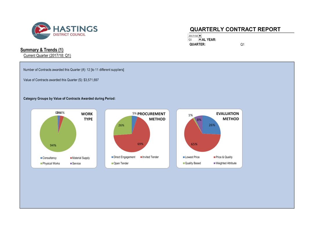
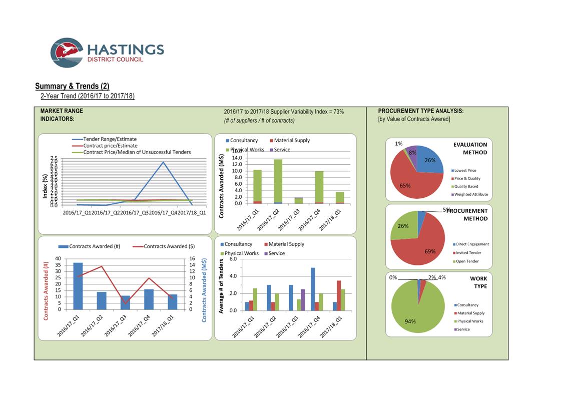
|
Project Status Report
|
Attachment 3
|
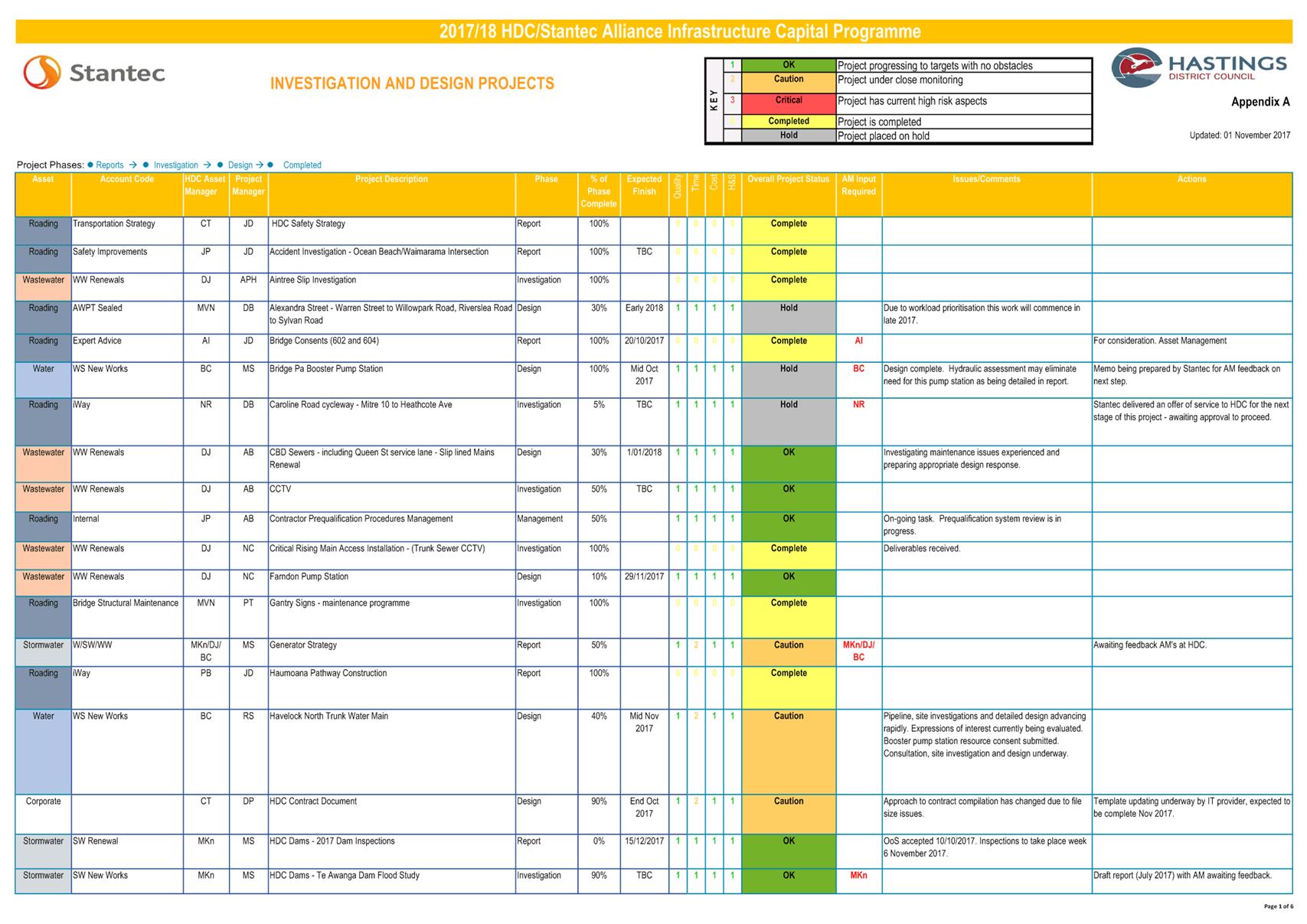
|
Project Status Report
|
Attachment 3
|
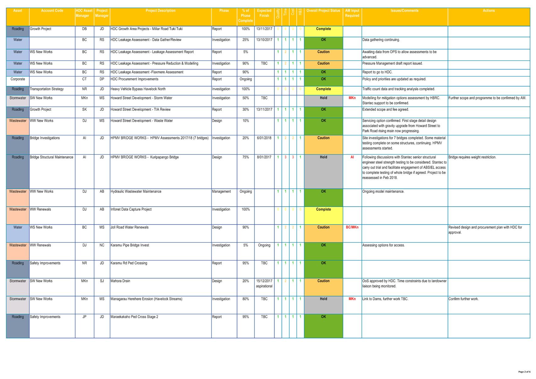
|
Project Status Report
|
Attachment 3
|
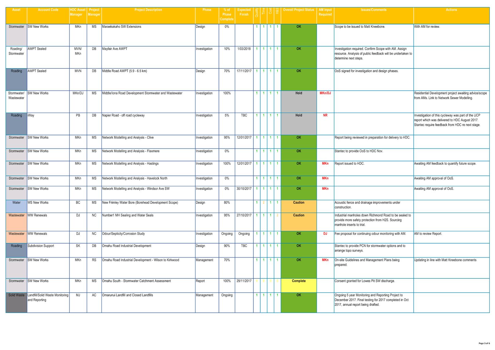
|
Project Status Report
|
Attachment 3
|
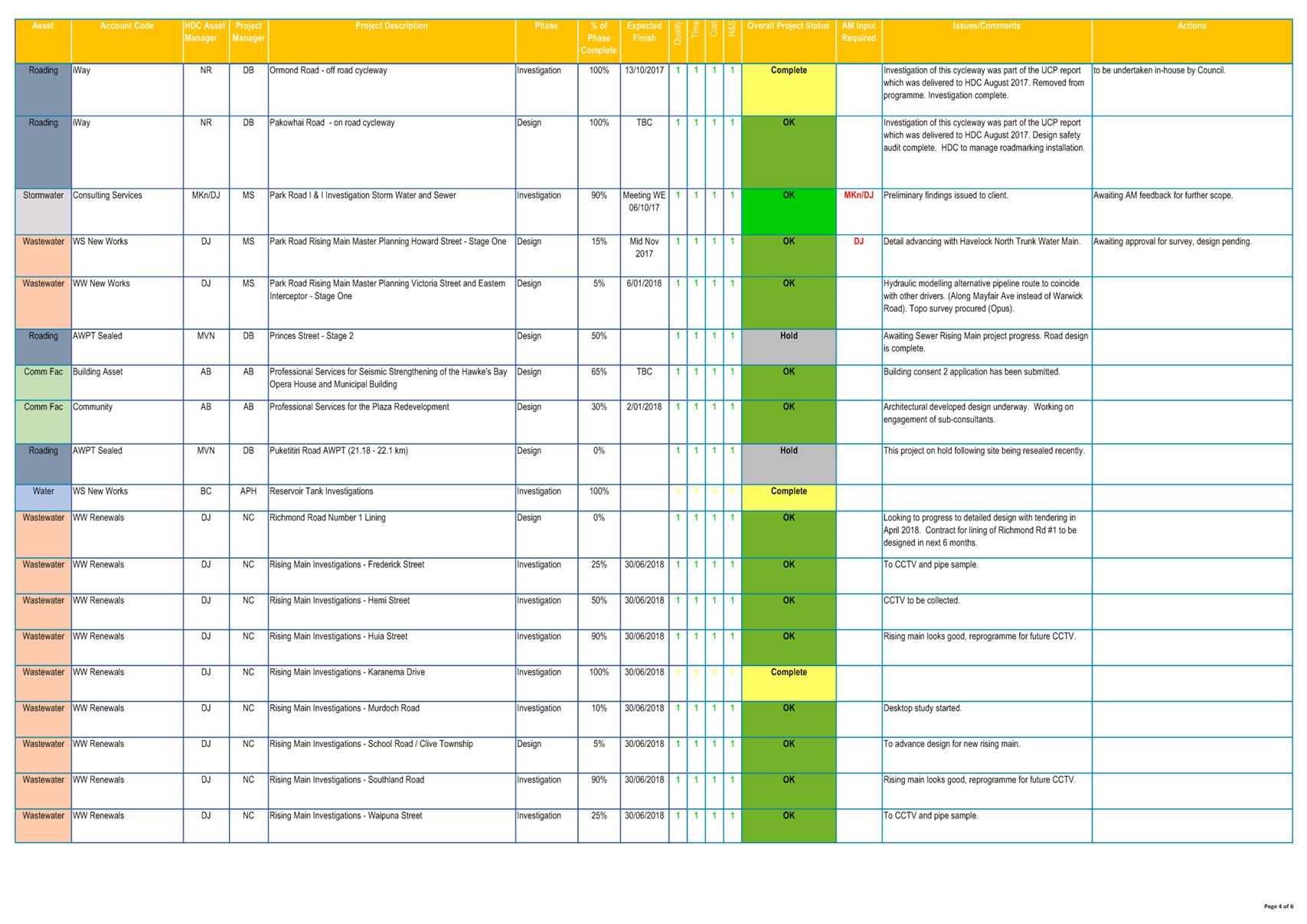
|
Project Status Report
|
Attachment 3
|
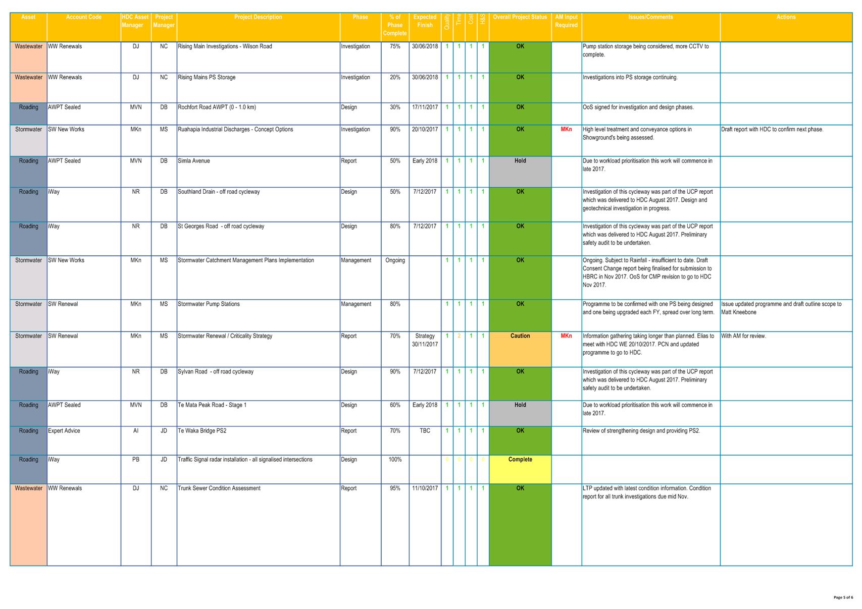
|
Project Status Report
|
Attachment 3
|
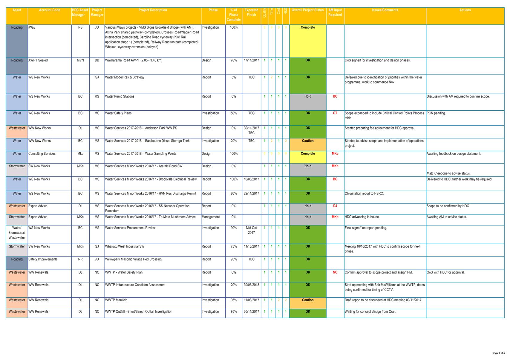
|
Project Status Report
|
Attachment 3
|
|
Project Status Report
|
Attachment 3
|
REPORT TO: Works
and Services Committee
MEETING DATE: Tuesday 21
November 2017
FROM: Acting Traffic Engineer
Kathryn
O'Reilly
SUBJECT: Clifton
Road Crossing
1.0 SUMMARY
1.1 The purpose of
this report is to obtain a decision from the Committee on the location of the
road crossing on Clifton Road in the vicinity of the Clifton shops.
1.2 This request
arises from the need to link the new cycle/pedestrian path along East Road to the
existing path along the foreshore.
Figure 1 - Area of concern
1.3 The Council is
required to give effect to the purpose of local government as prescribed by
Section 10 of the Local Government Act 2002. That purpose is to meet the
current and future needs of communities for good quality local infrastructure,
local public services, and performance of regulatory functions in a way that is
most cost–effective for households and businesses. Good quality means
infrastructure, services and performance that are efficient and effective and
appropriate to present and anticipated future circumstances.
1.4 The objective of
this decision relevant to the purpose of Local Government is to provide good quality infrastructure that is safe, affordable,
integrated, accessible, efficient, and effective in meeting the needs of
present and anticipated future circumstances.
1.5 This report
concludes by recommending the crossing point be located in front of 8 Clifton
Road. Linking the new and existing paths and remaining clear of the parking
zone in front of the shops.
2.0 BACKGROUND
2.1 The Haumoana link
pathway has been constructed or upgraded from the Haumoana School to the
residential area of Clifton. The new pathway linked into the existing footpath
on East Road just past the intersection of East and Rockwood Place.
2.2 A crossing point
in the vicinity of East Road, Clifton Road is required. Public
consultation was carried out, the information gained at the meeting assisted in
determining the best location. The consultation provided significant
information regarding the users of the facilities within the area of concern.
2.3 The key concerns
of those who attended the meeting are:
· Parking on the seaward side of the road
· The conflict between pedestrians, cyclists and motor vehicles
· The lack of defined entrance and exit points in front of the shops
· The way the bus stop has been inserted into the pathway (Refer
Figure 4)
2.4 Vehicles parking
on the seaward side, behind or on the pathway was the greatest concern. Little
to no consideration was being given to the other users by the motorists.
2.5 Moving the
pathway back towards the property boundaries was the preferred solution, this
would minimise conflict between pedestrians, cyclists and motorised vehicles.
2.6 The shop parking
is outside the scope of this project.
2.7 The pathway has
been constructed up either side of the bus stop. The bus stop is currently in
use, three buses in the morning and night pass through this area, dropping
school children off. The installation of a limestone path behind the bus stop
would link the section of existing pathway.
3.0 CURRENT SITUATION
3.1 Currently there
is not designated crossing point to link the coastal pathway and the East Road
pathway. Cyclist and pedestrian following the current pathway are directed to
the shopping areas carpark.
The area is heavily used
by a wide range of users, Cyclist, Motor Cyclists, Horse riders and motorised
vehicles. The conflict between motorised vehicles and all other users was prevalent,
in particular the area used for parking opposite the shops. The vehicles cross,
drive on and park on the pathway.
4.0 OPTIONS
4.1 Option 1
– Do nothing
This option provides
no guidance to path users as the where to cross, it is left to their own
discretion.
4.2 Option 2 –
Provide a crossing point prior to the shopping area.
The location of the
crossing point prior the shopping area was selected so as to minimise conflict
between cyclists, pedestrians and motorised vehicles. This area is a
50km/h posted zone therefore there is adequate sight distance from the corner
of East Road and Clifton Road to the crossing point for users to cross safely. 
Figure 2 – Crossing Point cross section
Separating the
parking on the seaward side of the crossing should be considered as part of
this option.
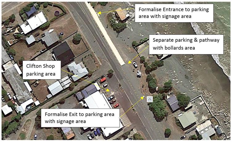
Figure 3 – Seawards side Parking Area
Connecting the two
sections of pathway on either side of the bus stop should also be included in
this option.
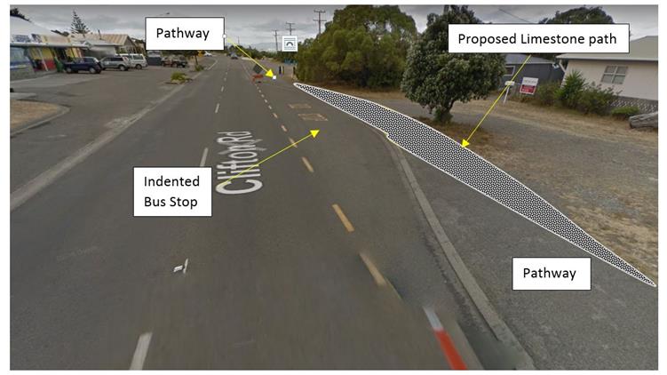
Figure 4 – Proposed Limestone path
4.3 Option 3 –
Move the pathway towards the foreshore and provide a crossing further down
Clifton Road.
This option has the
pathway moved back towards the property boundaries between number 1 and 15
Clifton Road. This moves the users way from the area used for parking on the
seaward side of the road. The cyclists and pedestrians are required to passing
through the shopping area car park, prior to crossing the road. To direct
pedestrians and cyclists through the parking area would require significant
alteration to this area.
The alterations would
be:
· Replacing the two smaller islands with one narrower longer island
· Creating one way traffic through the car park
· Change the parking to angle parking
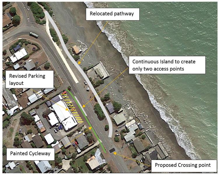
Figure 5 – Relocated pathway option
5.0 SIGNIFICANCE AND ENGAGEMENT
5.1 Public
Consultation was carried out, a flyer was dropped into the mail boxes of the
houses in the area. The properties adjacent to the proposed crossing north of
the shops, were emailed an invitation. The meeting was posted onto the Clifton
Facebook page and additional flyers were left at the shop. There were only 4
people who attended the meeting, however they provide well thought out
feedback.
5.2 The key issues
that were raised were:
· Parking on the seaward side of the road
· The conflict between pedestrians, cyclists and motor vehicles
· The lack of defined entrance and exit points in front of the shops
· The way the bus stop has been inserted into the pathway
5.3 The above issues
have been considered and addressed in the options presented.
6.0 ASSESSMENT OF
OPTIONS (INCLUDING FINANCIAL IMPLICATIONS)
6.1 Option one,
provide no guidance to the pathway users as to where it is safe to cross. This
is the least preferred option with a nil cost.
6.2 Option two
provides a defined crossing point and has the least area of conflict between
pathway users and motorised vehicles. The need to separate the parking on the
seaward side of the crossing point from the pathway would further minimise the
conflict. The linking of the two sections of pathway around the bus bay will
provide a definitive pathway through this area. This option is the preferred
option with implementation costs of $10,000 - $15,000.
6.3 Option three
provides safer passage along the foreshore from the intersection of East Road
and No 15 Clifton Road. The disadvantage with this option is the need for the
pathway users to cross through the shops car park to access a crossing point
further down Clifton road. This would be the second preferred option, with
implementation costs of $15,000 - $20,000.
6.4 From
the review it is clear that either proposed option will deliver benefits that
will outweigh the associated implementation costs. There is a clear need
for a solutions (either now or in the future) and the delivery will result in
enhanced safety, amenity and health.
6.5 The
funding for this work will come from the minor safety budget and the iway
budget.
7.0 PREFERRED
OPTION/S AND REASONS
7.1 Option
two is the preferred option.
7.2 This
option provides a defined crossing point with acceptable visibility.
7.3 The
users are crossing the road prior to a significant area of potential conflict
between pedestrians, cyclists and motorised vehicles.
7.4 Separating
the parking adjacent to the pathway, through delineation, will minimise the
conflict between pedestrians, cyclists and motorised vehicles.
7.5 Linking
the pathway around the bus bay will provide a definitive route through this
area.
|
8.0 RECOMMENDATIONS
AND REASONS
A) That
the report of the Acting Traffic Engineer titled “Clifton
Road Crossing” dated 21/11/2017 be received.
B) The Council approve the implementation of Option 2, installation
of a crossing point north of the Clifton shopping area.
With the
reasons for this decision being that the objective of the decision will
contribute to meeting the current and future needs of the Clifton community
for good quality local infrastructure by:
· Providing a defined crossing point
· Avoiding a significant conflict area
· Defining the seaward side parking
· Linking the pathway around the bus bay.
|
Attachments:
There are no
attachments for this report.
REPORT TO: Works
and Services Committee
MEETING DATE: Tuesday 21
November 2017
FROM: Group Manager: Asset Management
Craig
Thew
SUBJECT: Works
and Services Committee Report Major Projects Update as at Sept 2017 - 21
November 2017
1.0 SUMMARY
1.1 The purpose of
this report is to update the Committee about progress with Major Projects being
delivered across Council.
1.2 The Council is
required to give effect to the purpose of local government as prescribed by
Section 10 of the Local Government Act 2002. That purpose is to meet the
current and future needs of communities for good quality local infrastructure,
local public services, and performance of regulatory functions in a way that is
most cost–effective for households and businesses. Good quality means
infrastructure, services and performance that are efficient and effective and
appropriate to present and anticipated future circumstances.
1.3 This report
concludes by recommending that it be received.
2.0 CURRENT SITUATION
2.1 Individual
summary reports are appended (Attachment 1) for each of the following
major projects that are currently underway
· Opera
House
· Havelock
North 1A Trunkmain
· Te
Mata Road Upgrade
· Heretaunga
Street Upgrade
· Whakatu
Arterial Road
· Irongate
Industrial Development
|
3.0 RECOMMENDATIONS
AND REASONS
A) That the
report of the Group Manager: Asset Management titled “Works
and Services Committee Report Major Projects Update as at Sept 2017 - 21
November 2017” dated 21/11/2017 be received.
|
Attachments:
|
1
|
Works and Services Major Reports as at October 2017
|
CG-14-5-00043
|
|
Works and Services Major Reports as at
October 2017- Attachment 1
|
Attachment 1
|
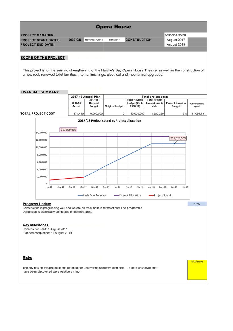
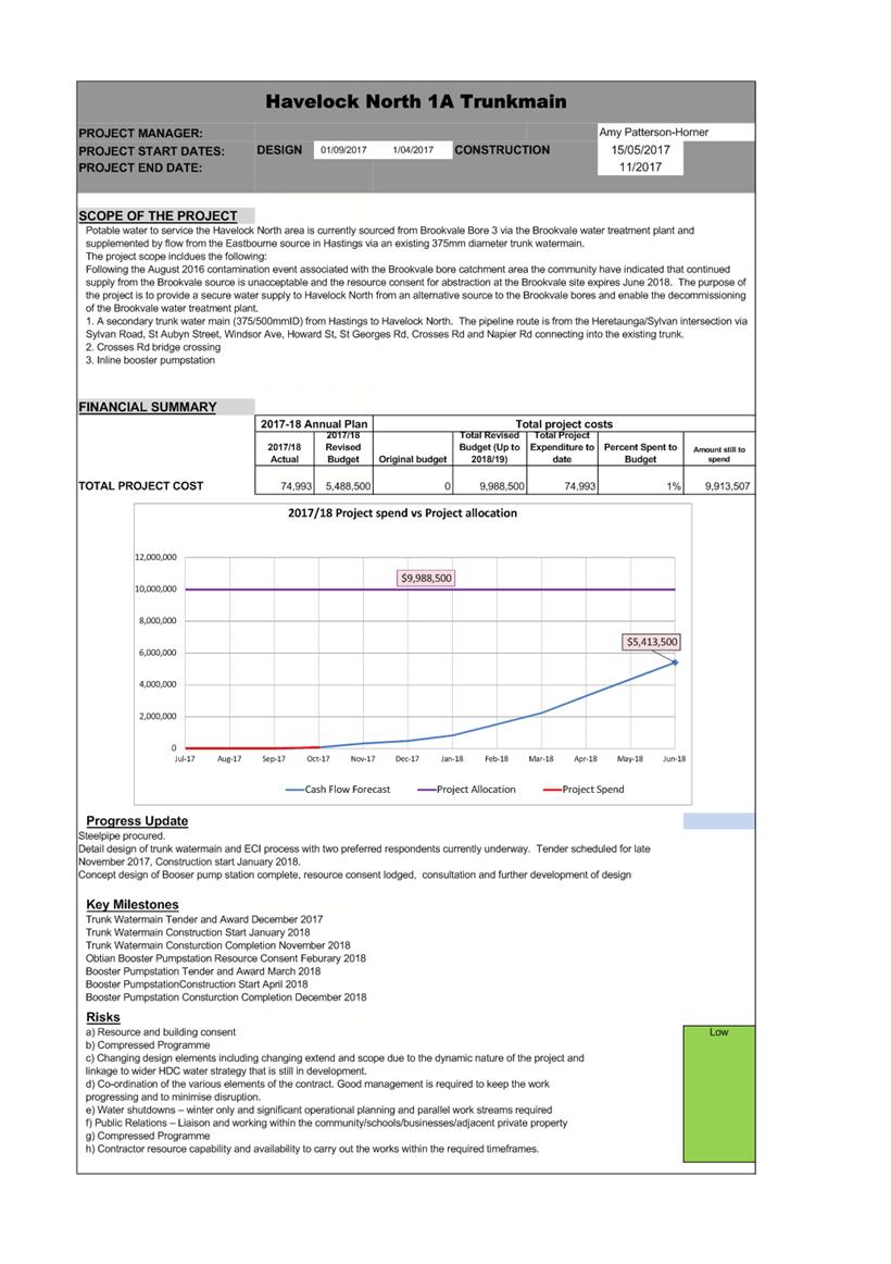
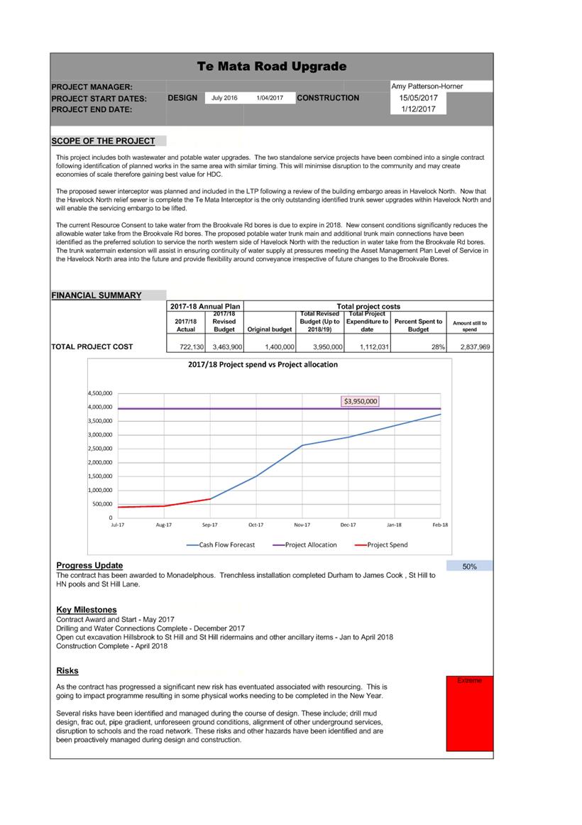
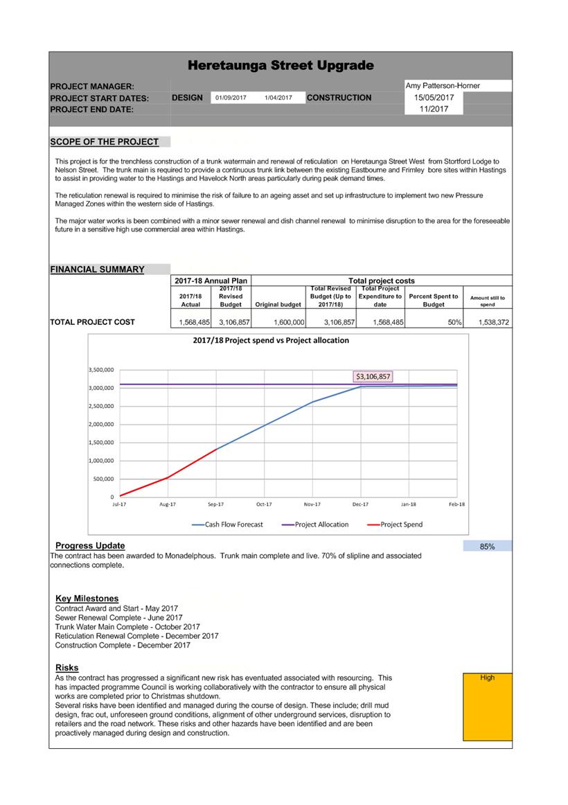
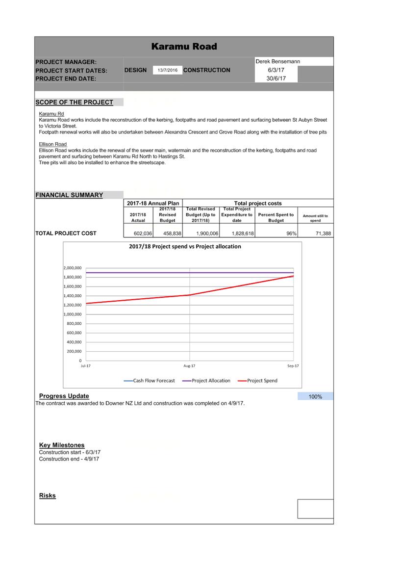
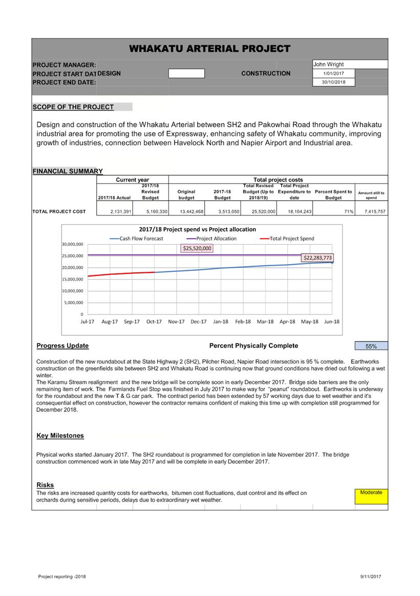
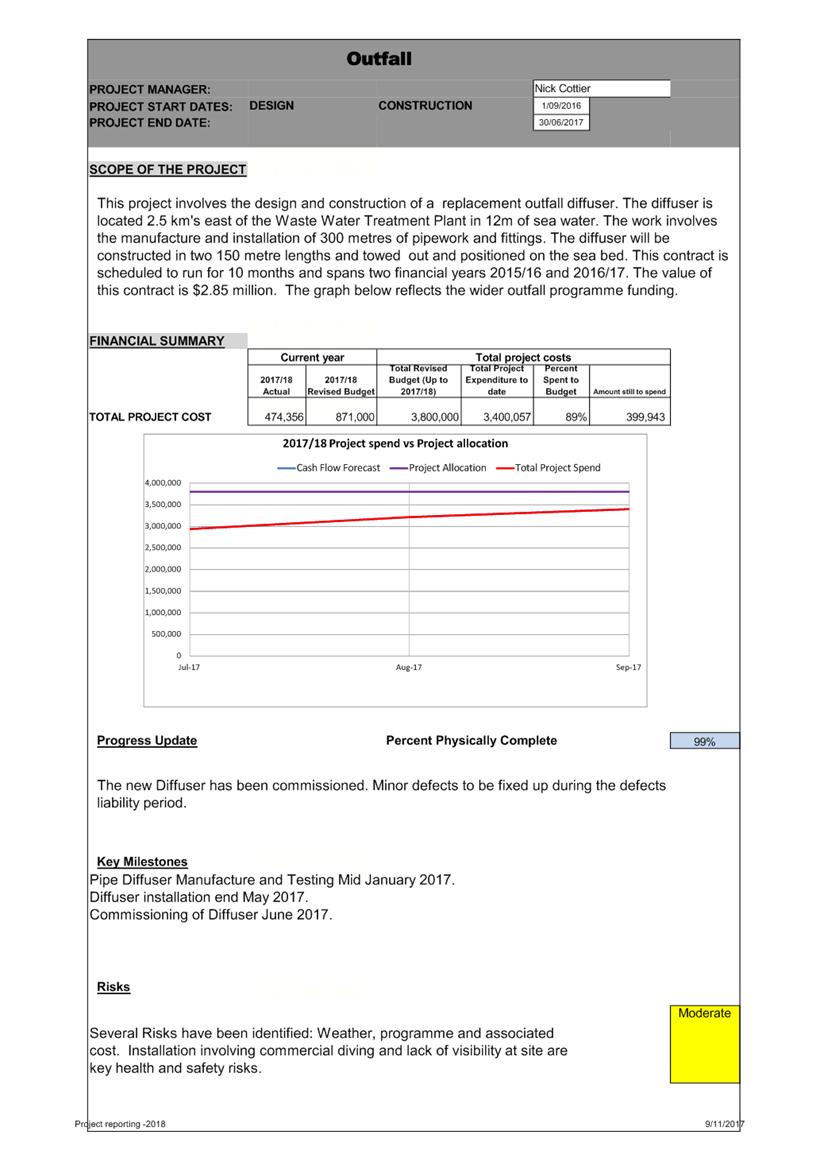
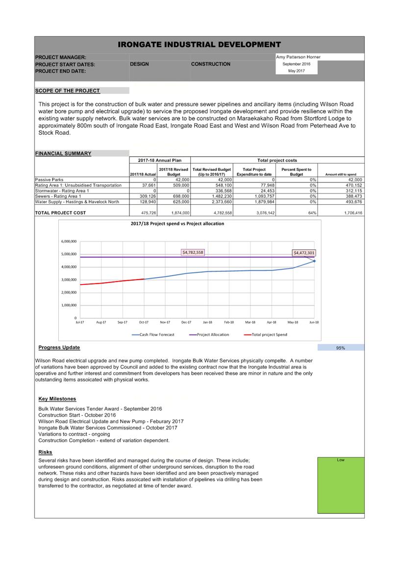
REPORT TO: Works
and Services Committee
MEETING DATE: Tuesday 21
November 2017
FROM: Group Manager: Asset Management
Craig
Thew
SUBJECT: Havelock
North Trunk Watermain and Booster Pumpstation Procurement Plan
1.0 Summary
1.1 The purpose of this report is to seek approval from the Works and
Services Committee on the procurement process for the construction of the
Havelock North trunk watermain and booster pump station.
1.2 This Procurement Plan was submitted to the Tenders Subcommittee for
approval because:1.3 The total project is required to be completed by December 2018
consisting of various contracts starting from December 2017. This deadline is
crucial to meeting summer peak demand from the alternative water supply and
enabling Brookvale Bore 3 to be turned off.
1.4 This report concludes by recommending that the Works and Services
Committee approve the proposed Procurement Plan and confirm the authority to
approve tenders to the combined value of $8,500,000 (excluding GST) to the
Tenders Subcommittee.
2.0 Background and Scope of Work
2.1 Havelock North is currently supplied treated water from Brookvale
Bore 3 via the Brookvale water treatment plant. Supply is augmented from the
Eastbourne bore water source in Hastings via the existing 375mm diameter trunk
watermain in Havelock Rd.
2.2 Following the August 2016 contamination which has been linked to the
Brookvale bore catchment area, a range of investigations have been undertaken
to determine the risks and consequences for continuing to abstract water from
Brookvale bore #3.
2.3 These investigations have determined that the source water in this
location is not secure and the environmental effects from the continued use of
this bore are unlikely to be acceptable as a long term option.
2.4 The current resource consent expires in May 2018 and there is an
expectation that HDC will move away from the Brookvale bore as a source of
water to Havelock North. It is also evident that the community supports a move
away from Brookvale to sources that will provide water that is of a superior
quality, be that from existing or new water sources.
2.5 The purpose of the project is to provide an alternative water supply
to Havelock North that enables the decommissioning and removal of the Brookvale
water treatment plant without compromising supply to consumers in the interim.
2.6 This project forms the first part of a comprehensive water supply
strategy with the objective to provide a water supply that is of high quality
and is safe, with sufficient quantity to meet existing and future demand. This
strategy advances from the original water strategy adopted by Council in 2012.
2.7 The project includes the following:
· Construction
of a new 5.4km trunk water main (500mm ID) from Hastings to Havelock
North. The pipeline route is from the Heretaunga/Sylvan intersection via
Sylvan Road, St Aubyn Street, Windsor Ave, Howard St, St Georges Rd, Crosses Rd
and Napier Rd connecting into the existing trunk watermain in Karanema Drive.
· Crossing the
Karamu Stream via Crosses Rd bridge
· Construction
of a booster pump station in Karanema Drive to deliver supply to reservoirs and
higher elevated parts of the Havelock North reticulation.
2.8 The intended completion of the above works is required by the end of
November 2018 in time to meet increased summer demand. This timeframe is
extremely tight given the extent of the work to be undertaken which requires a
procurement framework that enables timely procurement to meet tight programming
deadlines.
3.0 Proposed Procurement Model
3.1 The proposed Procurement Plan includes a range of contracts to be
procured via different methods. This approach is required to successfully
deliver the full scope of the proposed project within the ambitious programme
for the following reasons:
· The overall
project requires a range of different skills and expertise that are not readily
available via a single supplier.
· Multiple contracts provide the project team with the ability to
stage the design and procurement of various components to meet the overall
project programme and critical path for delivery.
· Construction will need to be occurring concurrently across a number
of areas and the availability of resources and expertise will need to be
procured via a number of different contractors and suppliers.
3.2 Market analysis of suppliers for each component part of the project
has been carried out. This analysis is discussed in detail within the
procurement plan.
3.3 Where a large national market is potentially available to complete
substantial components of the project, a two stage procurement method and
competitive tender process is recommended. This includes the main civil
contracts for laying the trunk watermain and building the booster pump
station.
3.4 Council’s prequalification system is recommended for smaller
components of work where there are appropriate categories. This includes
the proposed bridge strengthening work at Crosses Road.
3.5 Material supply items include emergency generator, pumps and VSDs
and the design has very specific requirements for these items. It is
recommended that these be procured via quotation by suppliers within New
Zealand that provide suitable equipment. Alternatively a sole source
purchase will be required if only one supplier’s offering is identified as
meeting all design and operational requirements. It
is estimated the total value of these supply items will be in the order of
$200,000 (ex. GST).
3.6 These minor direct engagement items fall within the delegated
authority of the CEO.
3.7 Request for Expressions of Interest (REOI)
3.8 An REOI was advertised in October and officers have short listed
candidates and notified them on 3 November 2017.
3.9 As part of the procurement process, The REOI enables HDC to select a
minimum of two suitably qualified contractors who best meet capability,
experience and track record criteria, to expedite the procurement process
whilst detail design is been completed.
3.10 The preferred respondents will participate in a simplified Early
Contractor Involvement (ECI) process including pre tender briefing meeting,
development of an accelerated programme and the finalisation of the detailed
design. On completion of the design the selected Contractors will be invited to
tender for the work.
4.0 Recommended exemptions to tender
4.1 A number of component parts of the overall project require suppliers
that are specialist in nature. These small specialist aspects have been
identified as critical to the overall success of the project and include:
· booster pump
station telemetry to be provided by SCADA Electrical. Estimated value less than
$15,000 (ex. GST).
· booster pump
station electrical installation and control to be provided by Controlbox.
Estimated value less than $50,000 (ex. GST).
4.2 Minor enabling works will be carried out prior to the end of
December 2017 under the existing HDC road maintenance contractor.
4.3 Unison will provide the required power supply
and transformer to the booster pump station. In this instance HDC do not
have an alternative supplier option as Unison are the only power supplier
available in the Hastings District.
5.0 Financial Implications
5.1 The total project estimate is $9,930,000 (ex.GST) comprising the new
watermain (estimated at $7.0M) and the Booster Pump Station (estimated at
$3.0M). This estimate has been developed from information available at this
time but prior to final detailed investigations being completed. It will be
further refined as the detailed design and investigations are finalised in
November.
5.2 Financial provision has been allocated for this project within the 2017/18 capital works budget of $12,000,000. This funding provides for upgrades to the water
network, new works and the provision of treatment at some of our water sources.
5.3 $5.5M of this budget has been assigned to this project within the
2017/18 financial year.
5.4 Purchase of the 500mm diameter concrete lined steel pipe has been
procured via a separate pipe supply contract (CON2017094) to the value of $1,489,760.00 (excluding GST) and this is
funded within the $5.5M allocation.
5.5 Approximately $4.0M of approved funding remains available
specifically for the watermain and booster pump station contracts to commence.
5.6 The estimated balance of $4.5M is included in the 2018/19 budgets
from within the LTP and is subject to Council approval through the LTP process.
5.7 The awarding of contracts and the financial commitment to this
project is required in advance of this funding being approved by Council
through the LTP.
5.8 The total budget estimate for which approval is being sought is $8.5M
(excluding GST).
6.0 booster pump station Issues
6.1 In addition to
the watermain, a booster pump station is required to deliver water to the
higher elevations in Havelock North and to maintain reservoir capacity. This
booster pump station enables the more efficient delivery of water into Havelock
North and maintains system pressures into the most elevated areas that have
historically been affected during peak summer demand.
6.2 Various sites for the pump station have been investigated,
considering the required system hydraulics and effectiveness, proximity to
major water main pipes, cost and time to implement. The initial site scan
focused on Council owned properties to mitigate time and cost risks. The
preferred site from this initial investigation is the small greenspace
alongside Karanema Drive (opposite the village green).
6.3 The project team commenced a resource consent application process
for the proposed works. The application would require the mitigation of effects
of the development at the boundary of the site. As part of the resource consent
application process the directly adjacent properties were contacted to inform
them of the project and the consent process. Following this initial discussion
with neighbouring properties wider concern was raised from other people in
Bennelong Place and wider surrounds so a public meeting was called and held on
13 November.
6.4 The community raised a number of questions and concerns (primarily
around noise, loss of amenity, and potential loss of property value).
Discussion on the proposed mitigations (which seem technically achievable) were
largely dismissed by the community with the message from the group that they
wanted it elsewhere. The group raised the option of an alternative site on
Karanema Drive. It was agreed to place a hold on any decision of the current
consent application until further work was done.
6.5 Officers are proceeding with an investigation and concept analysis
of the option raised at the community meeting to enable Council to consider
this against the current option. Council will then need to consider the options
with an assessment of the relative effectiveness, effects on community, cost,
and time. It is likely that the option objected to by those living closest to
it will still be the most cost effective and practical. If the environmental
effects from the pump station can be successfully mitigated, the Council will
need to weigh the remaining concerns of surrounding residents against the wider
benefits to the entire Havelock North community.
6.6 This delay is likely to affect the ability to complete the proposed
pump station before the 2018/19 summer period and therefore the ability to turn
Brookvale 3 off as an on demand supply by November 2018. The new pipeline can
continue as designed (except for section at the end) to be in place by December
2018.
|
7.0 RECOMMENDATION
A) That the report of the Group
Manager: Asset Management titled “Havelock North Trunk Watermain and
Booster Pumpstation Procurement Plan” dated 21/11/2017 be received.
|
Attachments:
|
1
|
CON2017099 Havelock North Trunk Watermain -
Procurement Plan Final
|
PRJ17-73-0045
|
|
|
CON2017099 Havelock North Trunk
Watermain - Procurement Plan Final
|
Attachment 1
|
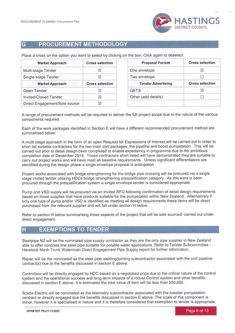
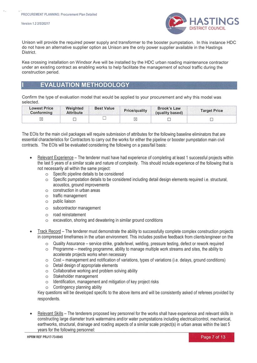
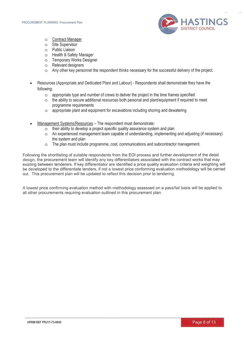
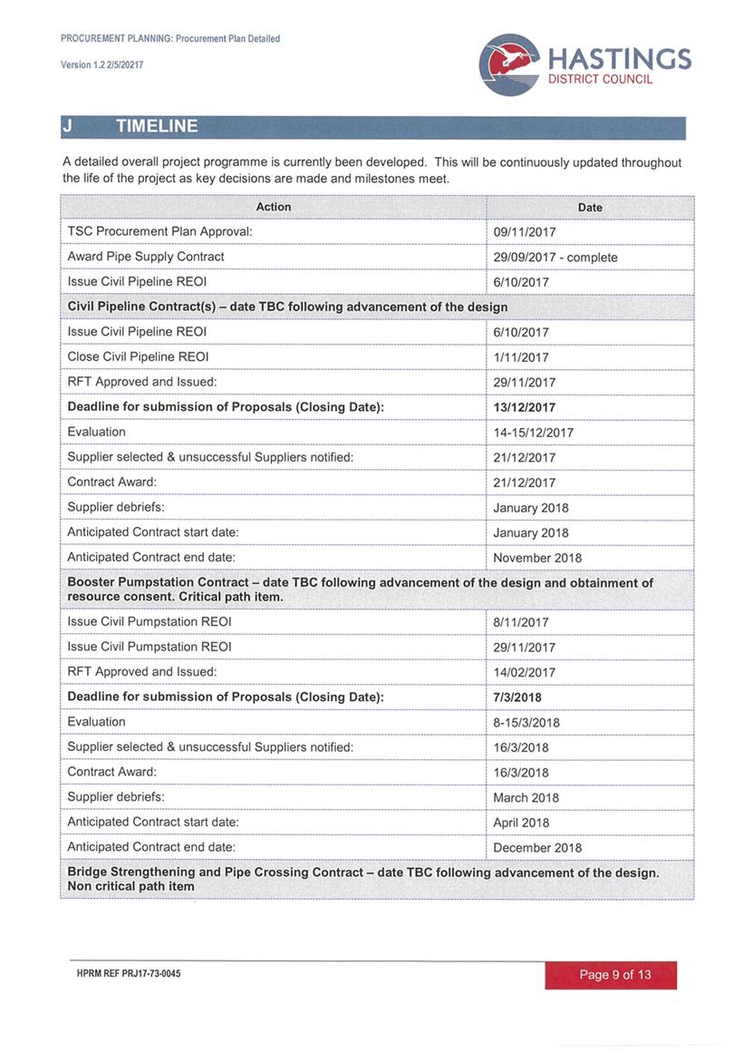
REPORT TO: Works
and Services Committee
MEETING DATE: Tuesday 21
November 2017
FROM: Executive Advisor/Manager: Office
of the Chief Executive
Mike
Maguire
SUBJECT: Summary
of Recommendations from the Tenders Subcommittee Meeting held 9 November 2017
1.0 SUMMARY
1.1 The purpose of this report is to advise that the recommendations
from the Tenders Subcommittee meeting held on 9
November 2017 require ratification by Council.
1.2 The report from the Transportation Operations Manager titled
“Transportation Maintenance Contract Procurement” which was
considered at the Tenders Subcommittee on 9 November 2017 is attached (Attachment
1).
1.3 The
relevant Tender Subcommittee recommendations to be ratified are set out below.
|
2.0 RECOMMENDATION
A) That
the report of the Group Manager: Asset Management titled “Summary of
Recommendations from the Tenders Subcommittee Meeting held 9 November
20172017” be received.
B) That the following recommendations of the Tenders
Subcommittee meeting held on 9 November 2017 be ratified:
“4. TRANSPORTATION
MAINTENANCE CONTRACT PROCUREMENT REPORT
A) That the report of the
Transportation Operations Manager titled “Transportation Maintenance
Contract Procurement Report” dated 9/11/2017 be received.
B) That the Tenders
Subcommittee recommends to the Works and Services Committee that;
i) The existing six term maintenance contracts
be amalgamated into:
· Rural Pavement and Corridor Management Contract
· Urban and Plains Pavement and Corridor Management Contract
· Street Lighting and Traffic Signal Maintenance; and
· Renewals Network Pavement Marking
ii) Approved tenure for all transportation term
maintenance contracts to be 4+1 (years).
iii) The procurement by Price Quality Method remain weighted
as 50% price, and 50% attributes.
iv) The Measure and Value (Traditional) Method to remain the
preferred contract model.
With the reasons for this decision
being that the objective of the decision will contribute to meeting the
current and future needs of communities for good quality local infrastructure
in a way that is most cost-effective for households and business”.
|
Attachments:
|
1
|
Transportation Maintenance Contract Procurement
Report
|
17/1064
|
|
|
Transportation Maintenance Contract
Procurement Report
|
Attachment 1
|
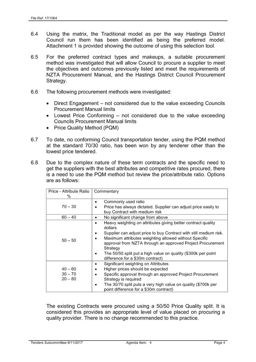
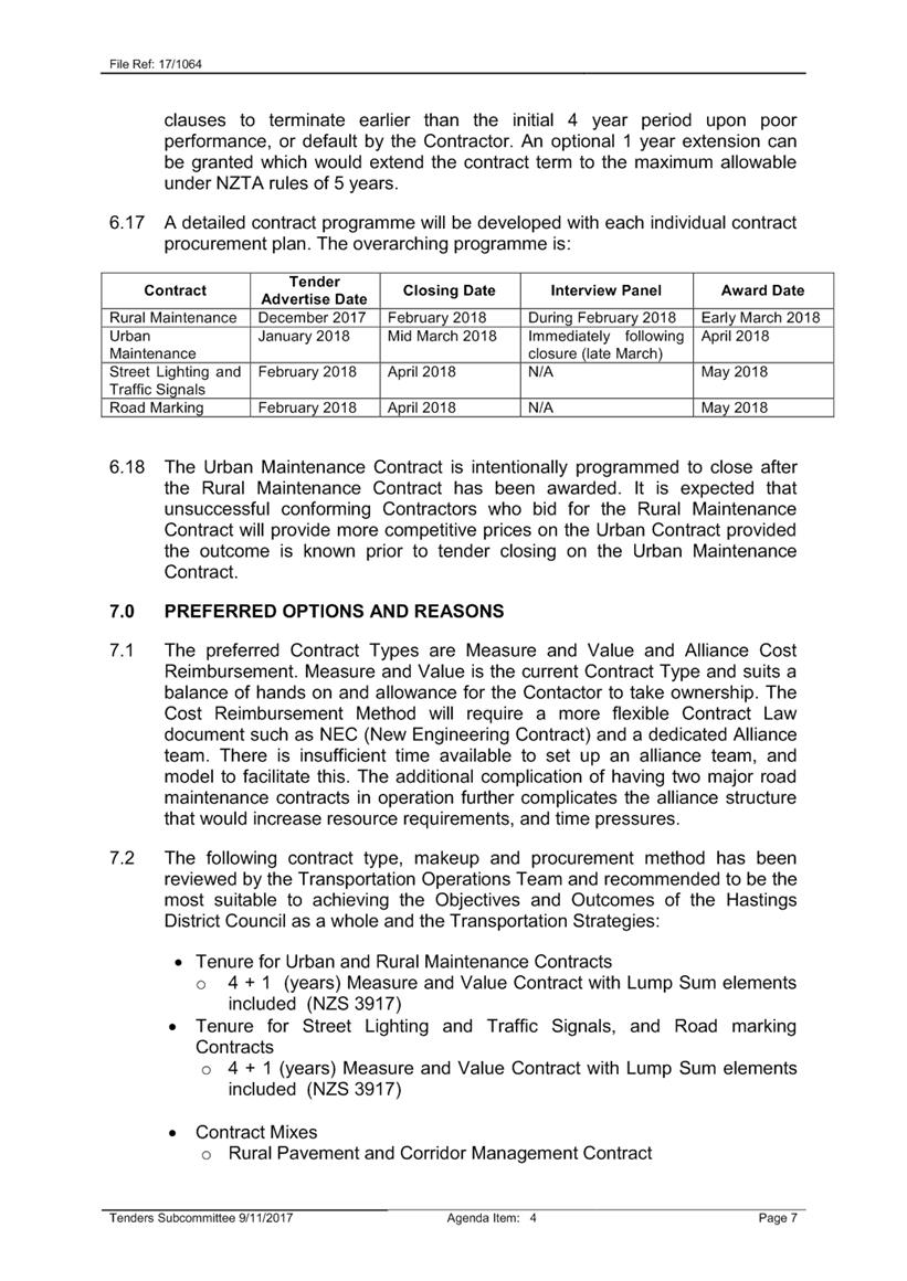
REPORT TO: Works
and Services Committee
MEETING DATE: Tuesday 21
November 2017
FROM: Bridge Engineer
Anu
Ileperuma
SUBJECT: Approval
to restrict bridges
1.0 SUMMARY
1.1 The purpose of
this report is to obtain a decision from the Committee to set speed/mass limits
pursuant to Heavy Motor Vehicle Regulations 1974 and Hastings District
Council’s consolidated bylaw, section (5.5.1 a).
1.2 This issue arises
from the update to the Vehicle Dimension and Mass (VDAM) rule set out by New
Zealand Transport Agency (NZTA).
The Council is
required to give effect to the purpose of local government as prescribed by
Section 10 of the Local Government Act 2002. That purpose is to meet the
current and future needs of communities for good quality local infrastructure,
local public services, and performance of regulatory functions in a way that is
most cost–effective for households and businesses. Good quality means
infrastructure, services and performance that are efficient and effective and
appropriate to present and anticipated future circumstances.
1.3 The objective of
this decision relevant to the purpose of Local Government is to provide current
and future communities with safe and good quality local infrastructure that are
efficient, effective and appropriate for present and future circumstances.
1.4 This report
concludes by recommending that pursuant to Hastings District Council’s
consolidated bylaw, section (5.5.1 a) and Heavy Motor Vehicle Regulations 1974,
that Council set speed/mass limits as described in the recommendation, that
the Chief Executive be delegated authority to publish above set speed/mass
limits notification as per Heavy Motor Vehicle Regulations 1974, section 11 (5)
and the Chief Executive be delegated authority to withdraw any individual
bridge restriction without further formality at the completion of the upgrade
of that bridge and to publish the withdrawal as per Heavy Motor Vehicle
Regulation 1974, section 11 (10).
2.0 BACKGROUND
2.1 As reported to
the Works and Services Committee on 20th June 2017 and Rural
Community Board on 11th September 2017, VDAM Rule had been updated
and came into effect on 1st February 2017.
2.2 The update
consisted of increasing the gross mass limit (total weight carried) of a
vehicle from 44 tonnes to 45 or 46 tonnes (Class 1).
2.3 Minor changes to
width, height and weighing tolerances were made along with increase in axle
weight allowed for public service vehicles (buses).
2.4 This increase
required Road Controlling Authorities (RCAs) to screen all the bridge assets to
the higher weight limits in the network and to restrict either weight, speed or
both on assets which are not capable of meeting the new weight limits.
2.5 Physical sign
posts are required to be in place by 1 December 2017.
3.0 CURRENT SITUATION
3.1 Screening of all
the bridges have been complete which indicated 30 bridges in our network were
not capable of meeting the increased load.
3.2 The screening
process and the physical restriction work will be paid 100% by NZTA.
3.3 These 30 bridges
include four restricted bridges which were existing prior to screening.
3.4 The list of
bridges identified were prioritised for upgrades following consultation with
transportation industry and rural meetings held.
3.5 A programme to
upgrade these bridges in order to remove the restrictions were presented to
Council workshop as well as Rural Community Board (RCB).
3.6 In accordance
with the legislative requirements (Land Transport Act 1998 and Heavy Motor
Vehicle Regulations 1974) and Council’s Consolidated Bylaw’s;
Council needs to resolve and notify prior to restricting any specified vehicle
or class of vehicle from using any road.
4.0 SIGNIFICANCE AND ENGAGEMENT
4.1 As mentioned in
3.4, meetings were held with key stakeholders who represented heavy transport
industry, farmers, forestry, fruit growers and stock.
4.2 This issue was
presented and discussed during a Long Term Plan (LTP) workshop held with
Councillors on 29 August 2017 and was discussed with The Rural Community Board
(RCB) on 11 September 2017.
4.3 Further
consultation occurred with regards to restrictions and timing of proposed
upgrades during five rural community meetings held in Tutira, Rissington,
Crownthorpe, Maraekakaho and Waimarama.
4.4 Some concerns
over bridges previously not identified through targeted stakeholder meetings
were put forward through rural meetings. These will be included for
consideration during the LTP discussions.
4.5 There will be
continued liaison with the RCB, targeted stakeholder group, Police
(enforcement) and the community.
5.0 CONCLUSIONS
5.1 This report
concludes by recommending that Council resolve to fix both mass and/or speed
limits for heavy motor vehicles, and combinations of vehicles including a heavy
motor vehicle, using the following bridges:
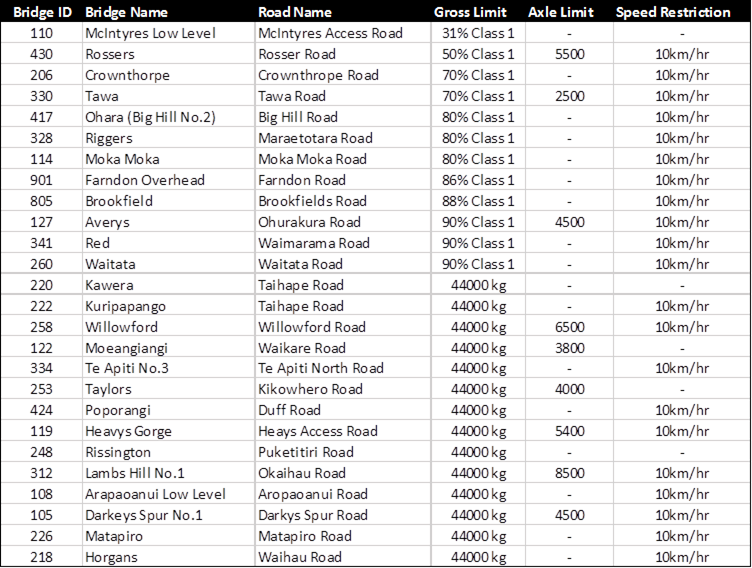
|
6.0 RECOMMENDATIONS
AND REASONS
A) That the
report of the Bridge Engineer titled “Approval to
restrict bridges” dated 21/11/2017 be received.
B) Pursuant to Hastings District Council’s consolidated bylaw,
section (5.5.1 a) and Heavy Motor Vehicle Regulations 1974, that Council set
following speed/mass limits:
|
Bridge ID
|
Bridge Name
|
Road Name
|
Gross Limit
|
Axle Limit
|
Speed Restriction
|
|
110
|
McIntyres Low Level
|
McIntyres Access Road
|
31% Class 1
|
-
|
-
|
|
430
|
Rossers
|
Rosser Road
|
50% Class 1
|
5500
|
10km/hr
|
|
206
|
Crownthorpe
|
Crownthrope Road
|
70% Class 1
|
-
|
10km/hr
|
|
330
|
Tawa
|
Tawa Road
|
70% Class 1
|
2500
|
10km/hr
|
|
417
|
Ohara (Big Hill No.2)
|
Big Hill Road
|
80% Class 1
|
-
|
10km/hr
|
|
328
|
Riggers
|
Maraetotara Road
|
80% Class 1
|
-
|
10km/hr
|
|
114
|
Moka Moka
|
Moka Moka Road
|
80% Class 1
|
-
|
10km/hr
|
|
901
|
Farndon Overhead
|
Farndon Road
|
86% Class 1
|
-
|
10km/hr
|
|
805
|
Brookfield
|
Brookfields Road
|
88% Class 1
|
-
|
10km/hr
|
|
127
|
Averys
|
Ohurakura Road
|
90% Class 1
|
4500
|
10km/hr
|
|
341
|
Red
|
Waimarama Road
|
90% Class 1
|
-
|
10km/hr
|
|
260
|
Waitata
|
Waitata Road
|
90% Class 1
|
-
|
10km/hr
|
|
220
|
Kawera
|
Taihape Road
|
44000 kgs
|
-
|
-
|
|
222
|
Kuripapango
|
Taihape Road
|
44000 kgs
|
-
|
10km/hr
|
|
258
|
Willowford
|
Willowford Road
|
44000 kgs
|
6500
|
10km/hr
|
|
122
|
Moeangiangi
|
Waikare Road
|
44000 kgs
|
3800
|
-
|
|
334
|
Te Apiti No.3
|
Te Apiti North Road
|
44000 kgs
|
-
|
10km/hr
|
|
253
|
Taylors
|
Kikowhero Road
|
44000 kgs
|
4000
|
-
|
|
424
|
Poporangi
|
Duff Road
|
44000 kgs
|
-
|
10km/hr
|
|
119
|
Heavys Gorge
|
Heays Access Road
|
44000 kgs
|
5400
|
10km/hr
|
|
248
|
Rissington
|
Puketitiri Road
|
44000 kgs
|
-
|
-
|
|
312
|
Lambs Hill No.1
|
Okaihau Road
|
44000 kgs
|
8500
|
10km/hr
|
|
108
|
Arapaoanui Low Level
|
Aropaoanui Road
|
44000 kgs
|
-
|
10km/hr
|
|
105
|
Darkeys Spur No.1
|
Darkys Spur Road
|
44000 kgs
|
4500
|
10km/hr
|
|
226
|
Matapiro
|
Matapiro Road
|
44000 kgs
|
-
|
10km/hr
|
|
218
|
Horgans
|
Waihau Road
|
44000 kgs
|
-
|
10km/hr
|
C) That
the Chief Executive be delegated authority to publish the above set
speed/mass limits as per the Heavy Motor Vehicle Regulations 1974, section 11
(5).
D) That
the Chief Executive be delegated authority to withdraw any individual bridge
restriction without further formality at the completion of the upgrade of
that bridge and to publish the withdrawal as per Heavy Motor Vehicle
Regulation 1974, section 11 (10).
With the reasons
for this decision being that the objective of the decision will contribute to
meeting the current and future needs of communities for performance of
regulatory functions in a way that is most cost-effective for households and
business by:
i) Providing safe and good
quality local infrastructure that are efficient, effective and appropriate
for present and future circumstances
|
Attachments:
There are no
attachments for this report.