|
Officer's Hearing Report
|
Attachment A
|
REPORT TO: HEARINGS
COMMITTEE
MEETING DATE:
FROM: REBECCA
JARMAN
ENVIRONMENTAL PLANNER (CONSENTS)
SUBJECT: LIMITED
NOTIFIED APPLICATION FOR SEASONAL WORKERS ACCOMMODATION AND SUBDIVISION
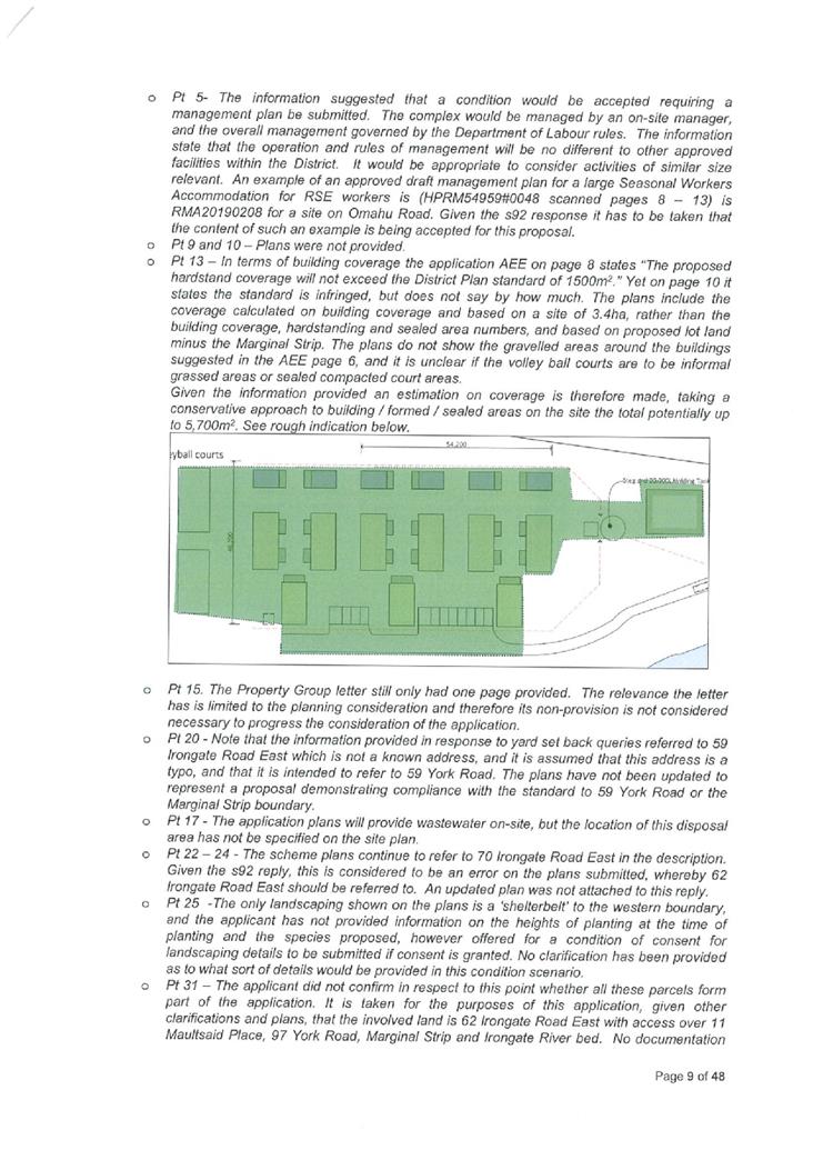
NOTE: This report sets out the advice of the reporting
planner. This report has yet to be considered by the Hearings Committee
delegated by the Council to determine this application. The recommendation is
not the decision on this application. A decision will only be made after the
Commissioners have considered the application and heard the applicant.
EXECUTIVE SUMMARY
|
Applicant:
|
JARA
Family Trust
|
|
Applicant’s Agent:
|
Development
Nous Limited
|
|
Site Addresses / Legal Description / Area / zoning / PID
Ref’s:
|
(as at
the time of application)
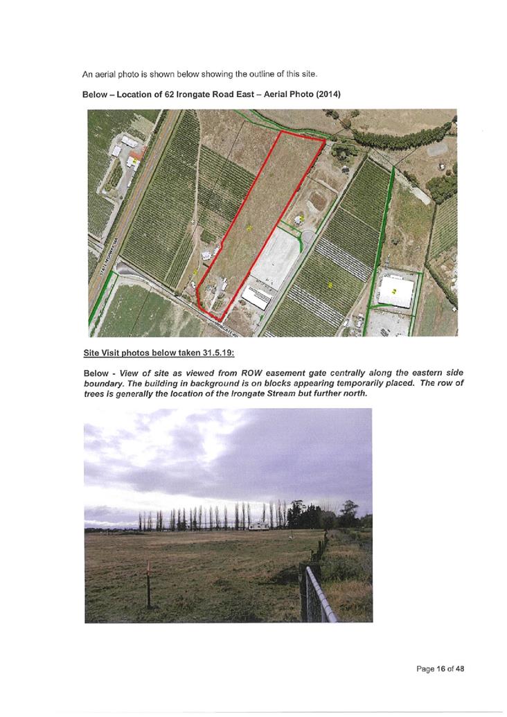
62
Irongate Road East, Hastings
- PID
25106
- legally
described at the time the application was made as Lot 1 DP 13268 (RT HBF1/19)
- 4.0469
Hectares
- Zoned
General Industrial (Irongate) under the Proposed Hastings District Plan
[consented
Lot 4 of this parcel which is the subject of this application, has been
subdivided and is now known as Lot 4 DP542005 and referred to hereafter as 9
Maultsaid Place]
And
97
York Road, Hastings
PID
54413
- legally
described as Part Section 24 Block XV Heretaunga Survey District and Section
66 SO Plan 438108 (RT 748603)
- 19.7011
Hectares including the area of Marginal Strip
- [Sec
66 SO 438108 is indicatively measured as approximately 2.6709ha being the
site area less the area of the Marginal Strip]
- zoned
Plains Production under the Proposed Hastings District Plan
And involving access over:
· 11
Maultsaid Place (legally described as Lot 3 DP 524530
– RT 837394) where a right of way extends from Maultsaid Place to serve
9 Maultsaid Place. – zoned General Industrial (Irongate).
· Irongate
Stream - the northern side of the stream is zoned Plains
Production and the southern side of the stream is zoned General Industrial
(Irongate)
· Marginal
Strip on both sides of the Irongate Stream remaining in
Crown ownership subject to Pt 4A of the Conservation Act.
|
|
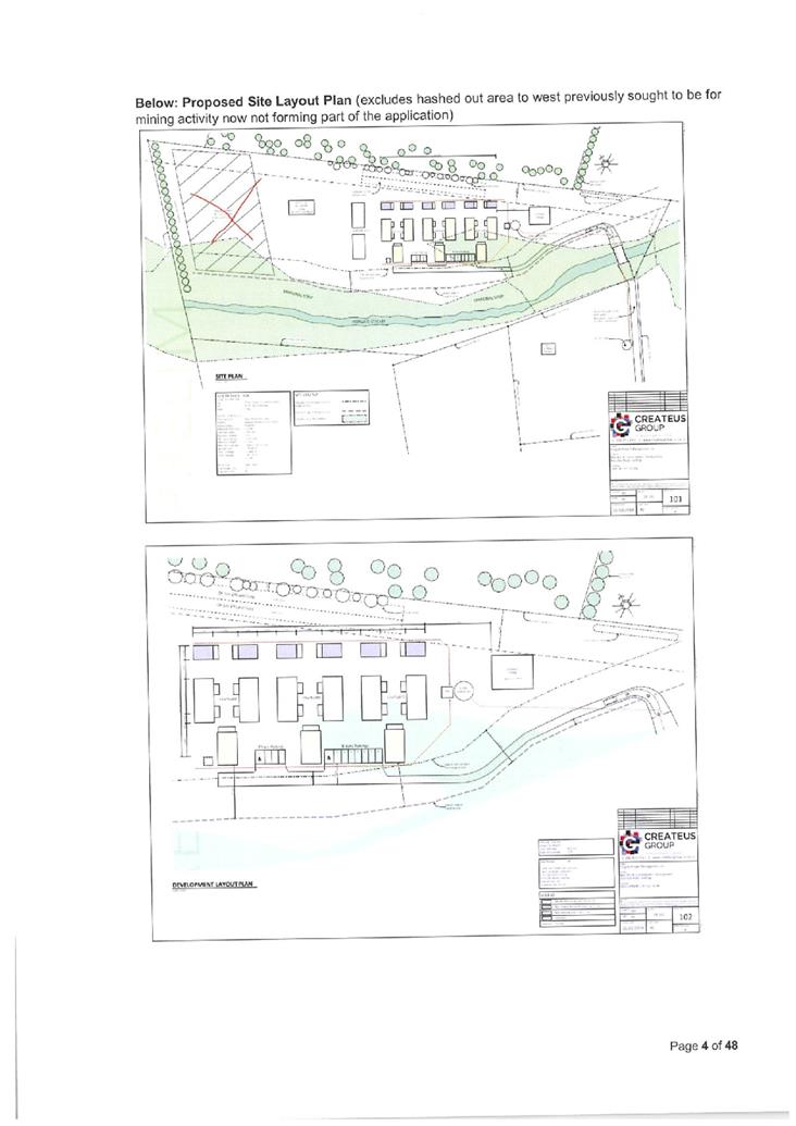
Proposal:
|
Subdivision of 97 York Road creating Lots 1
and 2, and amalgamating Lot 2 with 9 Maultsaid Place, involving a right of
way over Marginal strips and establishing bridge access over the Irongate
stream.
And
Land
use to establish
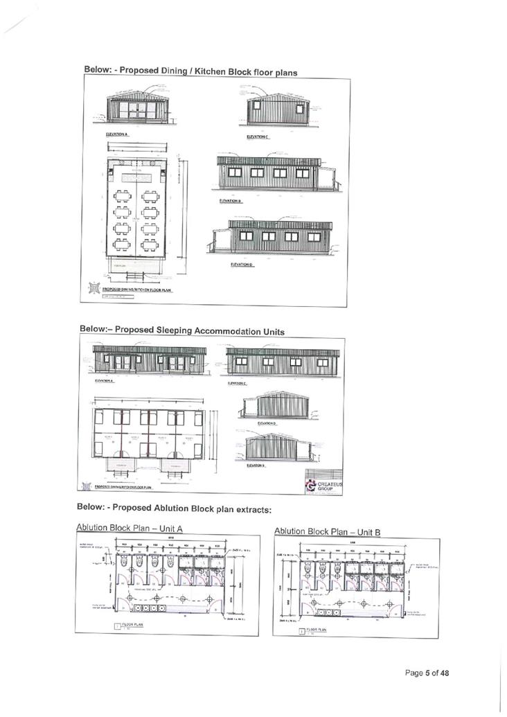
Seasonal Workers Accommodation for 150 persons involving establishing an
associated caretaker’s dwelling (Mangers unit), three kitchen/dining
blocks, six ablution/laundry blocks, six sleeping accommodation blocks and
two outdoor volleyball courts, along with associated establishment earthworks,
on-site wastewater discharge, water tanks and parking and access driveways.
|
|
Proposed Hastings District Plan
(PHDP) Provisions:
|
· Non-complying
Activity under the PHDP under SLD25 for the Section 11 RMA subdivision.
· Restricted
Discretionary under the PHDP under PP24 for Seasonal Workers Accommodation on
Plains Production zoned land and not meeting standards and terms and over
General Industrial zoned land.
· Restricted
Discretionary Activity under EM6 of the PHDP for earthworks associated with
the development.
|
|
Assessment of Status:
|
As a
bundled Non-Complying activity
|
|
Date consent application received:
|
30th May 2019
|
|
|
|
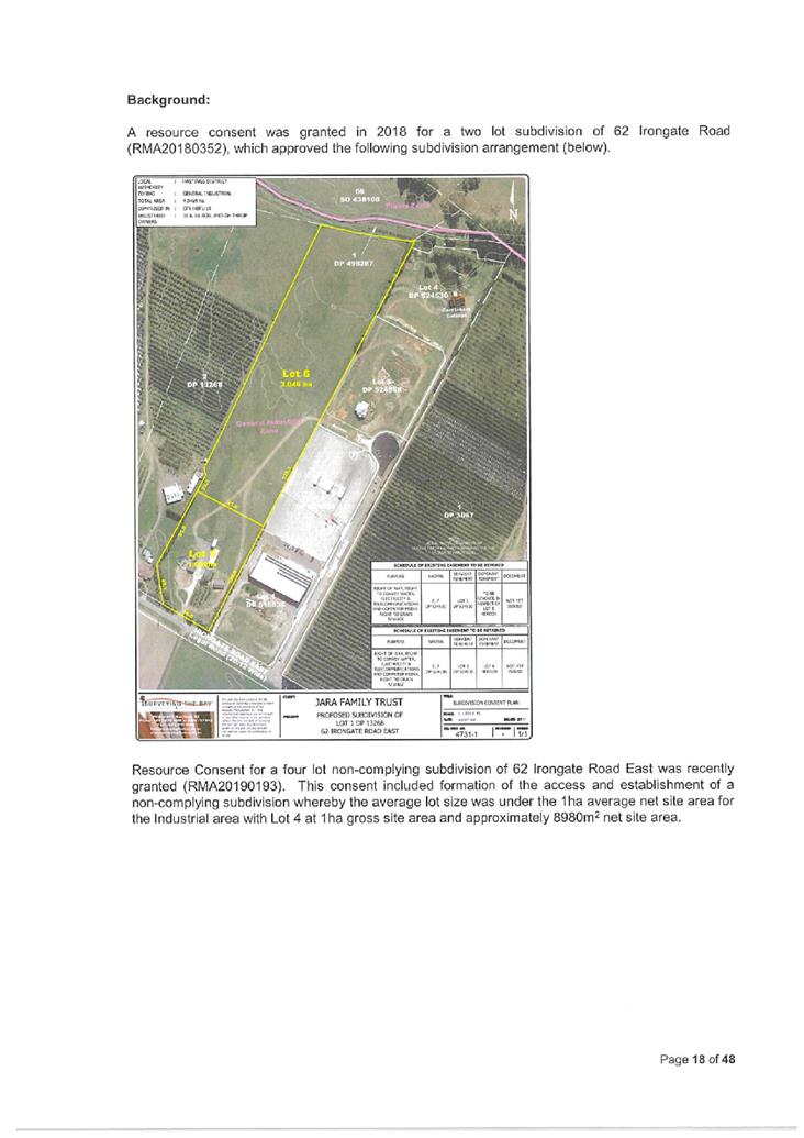
1. The applicant seeks
resource consent to undertake a two lot subdivision of 97 York Road and
amalgamate the southern Lot 2 created with land at 62 Irongate Road (9
Maultsaid Place). The access will be via a bridge over the Irongate
Stream and across Lot 2, and via other rights of way to Maultsaid Place.
The proposal also involves concurrent establishment of Seasonal Workers
Accommodation (SWA) for up to 150 persons, including establishment of
associated buildings for this activity including sleeping, ablution, kitchen /
dining facilities, managers unit and volleyball courts. Servicing for the
proposal is proposed to be either by way of on-site methods or via public
reticulation.
2. The full proposal is
described in Council’s Section 95A and 95B Notification Assessment Report
(‘Notification Report’) attached in Appendix B to this
report.
3. The following table
identifies the various attachments to this report.
|
Attachment
B
|
Section
95A and 95B Notification Assessment Report [‘Notification
Report’]
|
|
Attachment
C
|
Original
Application
|
|
Attachment
D
|
Council’s
Request for Further Information (S92 RMA) Letter
|
|
Attachment
E
|
Additional
Application Information Received
|
|
Attachment
F
|
Council’s
Development Engineers Comments
|
|
Attachment
G
|
Extract
of District Plan Standards 6.2.5D, H and 6.2.6K
|
|
Attachment
H
|
Copy of
RMA20190334 96 person SWA facility consent at 62 Irongate Road
|
|
Attachment
I
|
Copy of
RMA20190365 49 person SWA facility at 1139 Maraekakaho Road
|
|
Attachment
J
|
Copy
of RMA20190168 for 160 SWA facility at 22 Irongate Road.
|
|
Attachment
K
|
Copy
of Environment Court case law.
|
|
Attachment
L
|
Extract
from Hawkes Bay Regional Resource Management Plan (Regional Policy Statement)
|
4. A notification report
pursuant to section 95A and 95B of the Resource Management Act was undertaken
which identified parties potentially affected by the proposal. Council
determined under section 95B of the Resource Management Act that the
application be limited notified (see below table for parties notified).
5. The notification report is
in Attachment B and covers the following matters;
(a) Description
of the proposal;
(b) Further
information and responses to these;
(c) Background
to the proposal, and details of the information received;
(d) Description
of sites including photographs of the site and surrounding environment;
(e) Assessment
in accordance with National Environmental Standards for Assessing and Managing
Soil Contaminants in Soil to Protect Human Health Regulations 2011;
(f) Assessment
of the proposal against the provisions of the Proposed Hastings District
Plan;
(g) Resource
Management Act 1991 notification provisions which included an Assessment of
Effects on the Environment and Assessment of Affected Persons.
Council’s
Development Engineer has provided Development Engineering input on this
application for Council, his comments are attached in Attachment D to
this report. I accept the input and recommend adopting his recommended
conditions in the event that consent is granted.
The application
was limited notified on the 11th November 2019 to persons
considered to be affected by the proposed development, these persons were:
|
Name
|
Property to which they relate
|
Postal Address
|
|
Department
of Conservation
|
Bed of Irongate
Stream
And
Marginal
Strip shown on RT 737738.
And
Marginal
Strip shown across Sec 66 SO 438108 on RT 748603.
|
Attention:
Minister of Conservation of New Zealand
Department
of Conservation Te Papa Atawhai
Hawke’s
Bay Area Office
PO Box
644
Napier
4140
|
|
JK and
LM Hammond
|
59 York Road, Hastings
Legally described as
Lot 1 DP 24603 Block XV Heretaunga SD
|
JK and
LM Hammond
59 York
Road
Longlands
Hastings
4120
|
|
Hastings
District Council
|
Esplanade
Reserve to south of Irongate Stream adjacent to northern boundary 13
Maultsaid Place, legally described as Lot 5 DP 515835 (RT 816011)
And
Esplanade
Reserve to north of Irongate Stream adjacent to southern boundary of 59 York
Road, legally described as
Lot 7
DP 515835 (RT 816012)
|
Attention:
Public Spaces and Building Assets Manager
Hastings
District Council
Private
Bag 9002
Hastings
4156
|
|
Heretaunga
Tamatea Settlement Trust
|
|
Attention:
Liz Munro
Heretaunga
Tamatea Settlement Trust Trustees
PO Box
2192
Stortford
Lodge
Hastings
4153
|
6. Submissions closed on the
9th December 2019. No submissions were received at the close of
submissions.
7. A full assessment of
effects on the environment was undertaken for the Section 95A and 95B
notification assessment in Attachment B. That assessment remains
applicable to the substantive decision, and, other than noting any new
information relevant to the assessment of effects below, I have not repeated
the consideration of effects here. This hearings report therefore focuses on
the remaining matters relevant under section 104 of the Resource Management Act
1991.
8. By way of summary, the
effects assessment in the notification report was that the adverse effects on
the environment are minor and can be sufficiently controlled by way of
conditions of consent. In this regard, I note an important factor was
that the buildings would be relocatable and any effect on the soils resource
from the Seasonal Workers Accommodation activity would be temporary, and
minor.
9. I note that positive
effects are not able to be taken into account in the notification assessment,
but are relevant for the purposes of section 104. The Seasonal Workers
Accommodation would provide further accommodation required for these workers
and support the horticultural industry in the Hawkes Bay Region. This
beneficial outcome is considered to offset of the adverse effects that may be generated
from the Seasonal Workers Accommodation activity and associated establishment
works, given conditions of consent can further avoid or mitigate adverse
effects, and that the buildings are to be relocatable and thus temporary with
land being able to be returned to other uses in the future.
10. While the adverse effects of the
proposal are considered minor, and some positive effects are recognised, it is
considered that the proposal is contrary to the objectives and policies of the
Proposed Hastings District Plan. This is discussed further below, but
principally relates to the subdivision fragmenting Plains Production zoned
land, and being ad-hoc unplanned development of the rural area (particularly
Plains Production zone). It is further considered that the grant of
consent would create an adverse precedent and potentially undermine the
integrity of the Proposed Hastings District Plan. The proposal is considered to
be inconsistent with the direction of the Hawkes Bay Regional Policy Statement,
and my opinion is that it does not represent sustainable management of the
environment under Part 2 of the RMA.
11. Under Section 104D of the RMA the Committee
may consider granting the proposal as the adverse effects are considered to be
minor provided that consent conditions are imposed to mitigate effects that
would otherwise be more than minor. The Committee must then consider
whether it wishes to grant or decline the consent under section 104B of the
RMA.
12. Subject to any additional or further information
submitted at the hearing, it is my recommendation to decline the application on
the basis that the proposal is contrary to important objectives and policies of
the Proposed Hastings District Plan, relevant provisions of the Hawkes
Bay Regional Policy Statement and principles and purposes of the Resource
Management Act, that the grant of consent would, create an adverse precedent
and would potentially undermine the integrity of the Proposed Hastings District
Plan; and that the proposal is not in accordance with Part 2 of the RMA.
REPORTING PLANNER
13. My full
name is Rebecca Eva Jarman. I am currently employed as an Environmental Planner
(Consents) with the Hastings District Council. I hold a Bachelor’s
Degree in Resource and Environmental Planning from Massey University and have
practiced planning for over 20 years both in Local Government and in private
practice, in New Zealand and overseas at various levels, including in Senior
Planner and Team Leader roles.
14. I have read the Code of Conduct for
Expert Witnesses as contained in the Environment Court’s Consolidated
Practice Note (2014), and I agree to comply with it as if this hearing were
before the Environment Court. I confirm that the issues addressed in this
hearing report are within my area of expertise. I have not omitted to consider
material facts known to me that might alter or detract from the opinions
expressed.
ASSESSMENT PURSUANT TO SECTION 104 OF THE
RESOURCE MANAGEMENT ACT 1991
1.0 STATUTORY
CONSIDERATIONS
1.1 With
regard to resource consent applications for non-complying activities Section
104D of the Act states:
(1) Despite
any decision made for the purpose of section 95A(2)(a) in relation to adverse
effects, a consent authority may grant a resource consent for a non-complying
activity only if it is satisfied that either—
(a) the
adverse effects of the activity on the environment (other than any
effect to which section 104(3)(a)(ii)applies) will be minor; or
(b) the
application is for an activity that will not be contrary to the objectives and
policies of—
(i) the
relevant plan, if there is a plan but no proposed plan in respect of the
activity; or
(ii) the
relevant proposed plan, if there is a proposed plan but no relevant plan in
respect of the activity; or
(iii) both
the relevant plan and the relevant proposed plan, if there is both a plan and a
proposed plan in respect of the activity.
1.2 It
is noted that the proposal, if granted, would also be subject to consents from
the Hawkes Bay Regional Council (HBRC). These matters are addressed in
3.2 of the Officer’s ‘Notification Report’ in Attachment B to
this report.
1.3 The
‘Notification Report’ (Attachment B) concluded that the adverse
effects of the activity on the wider environment are no more than minor, while
there would potentially be adverse effects on other parties, being those who
were limited notified.
1.4 Section
104(1) RMA sets out those matters that Council must have regard to, subject to
Part 2, namely:
(a) Any
actual and potential effects on the environment of allowing the activity; and
(ab) any
measure proposed or agreed to by the applicant for the purpose of ensuring
positive effects on the environment to offset or compensate for any adverse
effects on the environment that will or may result from allowing the activity;
and
(b) Any
relevant provisions of:
(i) a national
environmental standard:
(ii) other
regulations:
(iii) a national policy
statement:
(iv) a New Zealand coastal policy
statement:
(v) a regional policy
statement or proposed regional policy statement:
(vi) a plan or proposed
plan; and]
(c) Any other matter the consent authority considers relevant
and reasonably necessary to determine the application.
2.0 SECTION
104(1)(a) - ASSESSMENT OF ENVIRONMENTAL EFFECTS – ACTUAL AND
POTENTIAL EFFECTS
2.1 A full
assessment of effects on the environment has been considered in 4.0 of the ‘Notification
Report’ (Attachment B). In addition to that assessment, the
following assessment and comments are made.
Additional Background
2.2 Since the
Notification Report was prepared, a Section 224(c) certificate has been issued
for the subdivision referenced RMA20190193 for subdivision of 62 Irongate
Road. Lot 4 DP 542005 of that subdivision is proposed as part of
the current proposal to be amalgamated with new Lot 2 of 97 York Road. At
the time of the notification assessment, I assessed effects based on new Lot 2
being amalgamated with the whole of 62 Irongate Road. That part of the
assessment no longer applies. I note that new Lot 4 is subject to
the following consent notice requirements (Council’s reference HPRM
25106#0158):
1. There is
no reticulated stormwater system available for this site.
2. All
stormwater discharge shall be disposed of within the site (on-site).
3. At the
time of any building consent application, and when any impervious areas are
added to the site, a design for the management and disposal of on-site
stormwater discharge (Stormwater Management Plan - SMP) shall be submitted to
the satisfaction of, and for the approval of, the Council. The details
provided for the SMP shall include site specific infiltration testing and
reporting prepared and undertaken by a suitably qualified and experienced
Engineer. The details for the SMP shall be supported by plans and
information of the proposed development / impervious areas and shall
satisfactorily demonstrate how the stormwater discharge will discharged
on-site.
4. This site
shall not discharge any stormwater directly to the Irongate Stream.
5. Resource
Consent from the Hawke’s Bay Regional Council to discharge stormwater to
land and/or water may also be necessary prior to any development.
6. That the total sanitary
(domestic) discharge to the Council wastewater network in Irongate Road East
from the land contained within Lot 1 DP 13268 with a total area of 4.05
hectares shall be restricted to a maximum wastewater volume not exceeding
14,000 litres per day. This shall be allocated to each of the Lots as follows:-
· Lot 1 maximum wastewater volume not exceeding 5,220
litres per day,
· Lot 2 maximum wastewater volume not exceeding 1,730
litres per day,
· Lot 3 maximum wastewater volume not exceeding 3,950
litres per day,
· Lot 4 maximum wastewater volume not exceeding 3,100
litres per day
2.3 Furthermore,
the following decisions have been made since the notification report, and are
relevant to the assessment of the current proposal.
For information, in the locality of the subject site the following is
noted:
· RMA20190365
– Applicant: Hawkes Bay Project Management Limited (title showing site in
ownership of JA Roil, RA Roil and GH Thorp), The proposal was made under the
Operative Hastings District Plan and Proposed Hastings District Plan (Variation
7 – SWA) as a non-complying activity for 48 Seasonal Workers in the
General Industrial zone at 1139 Maraekakaho Road (near corner of Maraekakaho
Road and Irongate Road), granted 4 December 2019 on a non-notified basis under
delegated authority. [Copy of decision in Attachment I]
· RMA20190334
– Applicant: John Roil (one of the site owners along with RA Roil and GH
Thorp). Proposal under the Proposed Hastings District Plan as a
non-complying activity in the General Industrial zone, being an application
made prior to the notification of Variation 7 – SWA to the Proposed
Hastings District Plan. This consent is for accommodation for 95 Seasonal
Workers and one manager (total 96 persons) at 9 Maultsaid Place (Lot 4).
Consent was granted on the 4th December 2019 on a non-notified basis under
delegated authority. Conditions of consent include establishment of access and
parking, acoustic measures to buildings, provision of a Site Management Plan,
imposition of a reverse sensitivity covenant, establishment of landscaping
(including shelterbelt planting along the northern boundary to the Irongate
Stream), imposition of a restrictive covenant on a remote site at 1139
Maraekakaho Road in the Irongate General Industrial zone that reduces the
potential wastewater discharge capacity of that site to account for higher
discharge from 9 Maultsaid Place; provision of water supply, management of
lighting and glare and construction controls such as construction noise and
earthworks sediment and erosion management. [Copy of decision in
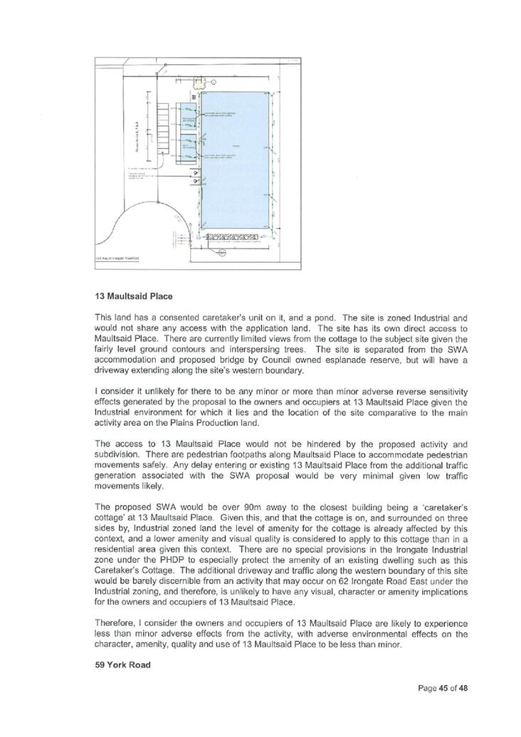
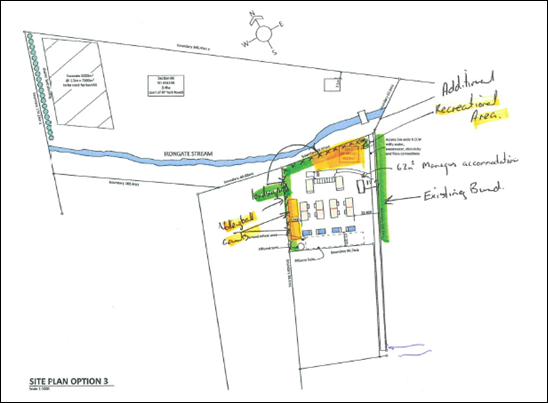
Attachment H] See extract of consented plan below.
In respect of
the above application, it is noted that the proposal does not comply with the
underlying consent notice for 9 Maultsaid Place relating to wastewater
discharge limits. In order to utilise the land use consent for Seasonal Workers
Accommodation on Lot 4 DP 542005 a s221 RMA change of consent notice application is still required.
For the
purposes of this application the above two consents form part of the existing
consented environment and the adverse effects of the proposal must reasonably
therefore be considered inclusive of these and on a cumulative basis in the
below assessment of effects.
· RMA20190168
– Applicant: Bostock NZ Irongate Limited (title showing site in ownership
of Bostock NZ Irongate Limited). The proposal was made under the Proposed
Hastings District Plan prior to the notification of Variation 7 - SWA as a
non-complying activity for earthworks and Seasonal Workers Accommodation for
160 persons in the General Industrial zone at 22 Irongate Road East, granted
non-notified under delegated authority on the 4 July 2019. [Copy of decision in
Attachment J].
The above four
consents illustrate that there are alternative suitable locations for the
provision of SWA in the Industrial area for large scale SWA.
There have
been numerous resource consents issued by Council under the Proposed Hastings
District Plan provisions for establishing Seasonal Workers Accommodation in the
Plains Production zone under the same provisions the subject application is
subject to. These vary in size, scale and location, with all considered
in their own context and environment.
However,
resource consents have also been issued more recently that are subject to
Variation 7 – Seasonal Workers Accommodation, to the Proposed Hastings
District Plan.
For
information, resource consent referenced RMA20190412 for accommodation for 86
seasonal workers at 232 Twyford Road, Twyford has been granted on the 17
December 2019, in the Plains Production zone. This accommodation is sited
in a location benefitting by substantial screening due to existing orchards and
shelterbelts.
None of the
above decisions, or other historical seasonal workers accommodation resource
consents I have reviewed, have involved subdivision to facilitate or enable the
use.
· Building
Consent referenced ABA20191083 by Council was granted in September 2019
relating to Lot 3 of 62 Irongate Road East (now known as 7 Maultsaid
Place) south of subject Lot 4 (known as 9 Maultsaid Place). This involves
a 1,250m² workshop and associated office/staff facilities block, and
on-site stormwater disposal area.
Permitted
Baseline
2.4 Section
104(2) states that in the assessment of effects under section 104(1) Council
may disregard an adverse effect of the activity on the environment if a
national environmental standard or the plan permits an activity with that
effect. Permitted Baseline is not considered useful for this proposal,
whereby the application is considered as a bundled activity and all subdivision
requires a resource consent.
2.5 In terms
of land uses it appears from aerial photos that the existing activity on 97
York Road (combined parcels) may already be over the site coverage, so any
additional buildings would likely require a resource consent.
2.6 In terms
of the existing environment however it is noted that Land Based Primary
Production currently occurs on 97 York Road, there is an existing dwelling on
the site and associated accessory buildings, and effects associated with such
uses are acknowledged.
Affected
Persons Consent
2.7 Section
104(3) states that the consent authority must not have regard to: (a)(i) trade
competition; and (a)(ii) any effect on a person who has given their written
approval to the application.
2.8 I have
not had regard to trade competition nor the effects of trade competition for
the purposes of this assessment.
2.9 The
attached ‘Notification Report’ addresses written consents on page
37. For clarification, no written consents have been provided with the
application, albeit for the purposes of Section 95E considerations no persons
were deemed adversely affected, by way of S95E(3)(b) of the RMA. Therefore
consideration is given to effects on all parties as a part of the below
considerations.
Consideration of Effects
2.10 In
addition to the effects assessment in 4.0 of the ‘Notification
Report’, the additional comments are made. The below comments
should be read in addition to the effects assessment in 4.0 which, as noted
above, is not repeated here.
Effects on Plains Production / Versatile
soil / land
2.11 The
proposed SWA development would utilise only a small area of the wider versatile
land resource.
2.12 The
SWA is to be established with ‘relocatable’ buildings, in that the
activity is able to be removed / disestablished readily upon the demand or need
for the SWA being no longer being required. In effect this ensures that the use
is more ‘temporary’ and the land resource can be adapted into other
uses. If consent is granted I consider it appropriate to impose a condition of
consent to ensure that upon cessation of the SWA activity in the buildings that
the buildings and associated features are removed from the site. This is
consistent with the approach taken in other consented SWA activities. If
repurposing is to be proposed, then a separate consent could be sought at that
time to address the suitability of any future use.
2.13 The
proposal includes substantial building coverage. This utilises the land
resource and has a potential effect of minimising its ability to be utilised
for alternative uses in the future. 97 York Road currently appears to be
over building coverage. The applicant may wish to clarify this at the
hearing. The proposal increases this much further. It is not uncommon for
SWA to exceed the site coverage standard in the Plains Production zone, with
other consents granted for an exceedance. However, it is considered
appropriate to minimise the degree of necessary coverage utilised for the SWA
activity. This would ensure that less land would need reverting if the
activity is removed in the future. The application information does not
show the extent of coverage clearly. I recommend that, if consent is
granted, a specific site plan is provided clearly detailing the necessary
surfaces on the site and afford some certainty as to the area to be included in
building coverage (including hardstand and sealed areas). The applicant
could provide a plan detailing this at the hearing to provide this certainty.
2.14 Subject
to the comments above, it is considered that the coverage and use of Lot 2 for
Seasonal Workers, in itself, would have no more than minor adverse effects on
the versatile land resource as a whole.
Visual
Amenity and Character
2.15 The application
information has limited assessment on the adverse visual effects and character
effects of the proposal. I consider that given the low profile of the proposed
buildings and their separated location from other uses that there would be no
more than minor wider adverse visual amenity and character effects on the
environment from the SWA activity. In the immediate vicinity of the
site however, I consider that some softening, visual screening and buffering of
the SWA from surrounding sites would assist in minimising the hard appearance
of the buildings in the setting so they are better visually absorbed in this
context. I do not consider that screening from the adjacent industrial
zoned land is necessary, given their use and likely planting along their
interface boundary with the Irongate Stream.
2.16 The
proposed buildings face the Irongate Stream and Marginal Strip and would
present a visual face to this over 40m wide width. The SWA activity would
take up a substantial length of the Marginal Strip frontage on the northern
side of the Irongate stream. Nevertheless given the buildings are to be
set at least 15m from the marginal strip, with open parking area between, I
consider there to be sufficient separation for the buildings to not present an
unreasonable and overly dominant or intrusive appearance to this public
space. However additional planting to soften the hard surfaces along the
southern side of the SWA facility would further assist in mitigating the built
form bulk and hardsurfacing on this site with the stream interface. The steam
network already has industrial land along the southern side and the stream
vista has been interrupted by the state highway culvert. Adding additional bulk
in the form of SWA activity adds visually to this context and without buffering
and softening it would be to stark for the rural context. If consent is to be
granted, I recommend a condition to be included to for additional planting to
this effect.
2.17 The
proposed bridge would introduce a further structure across the stream, smaller
than the existing culvert for the State Highway. The structure is
relatively small in the context of the wider stream network. The part of
the stream where the bridge is going is fairly open and in my view, a proposed
bridge would not be in character with this existing environment. However,
in the context of the stream being adjacent to industrial zoned land and the
state highway culvert, I consider that this loss of character would be minor.
2.18 Use
and enjoyment of the Marginal Strip and HDC esplanade reserve forms part of the
amenity of these spaces. However there are currently few users of the
marginal strip and adjoining HDC esplanade reserve as a result of its location
and it not forming part of a wider network. I have not been informed of
any plans from the Department of Conservation or Hastings District Council with
regards to proposing wider network linkages for use of these public spaces, at
this time. Therefore I consider there to be likely minor adverse effects
on the use and enjoyment of the Marginal Strip and HDC esplanade reserve
resulting from the proposal.
2.19 While
the applicant has offered conditions of consent with respect to landscaping,
the details of what type of planting this might involve has not been provided.
The application includes screening in accordance with Standard 6.2.5D (see
Attachment G) of the outdoor storage and parking areas of the SWA activity from
a residential activity. This applies to screening particularly for the nearby
caretakers dwelling at 13 Maultsaid Place and those on 97 and 59 York Road.
More details on the planting and location to be undertaken to achieve this
standard would assist in better understanding visual and character implications
of the proposal for surrounding properties.
2.20 SWA
facilities will often have an outdoor clothes drying area. For 150
persons this equates to a potentially large area of clothes lines.
Identifying the nature and area of this activity on a site plan and including
screening for this area/s is recommended as a condition of consent, if Council
is minded to grant consent.
2.21 The
applicant has also shown on the plans planting along the State Highway edge of
the property. Planting along this edge may afford some buffering and screening
of the site from the State Highway. However more details on the planting
is required to understand the effectiveness of such planting. The
Department of Conservation will need to separately agree to the planting within
the Marginal Strip for this planting to occur.
2.22 The
Proposed Hastings District Plan provides a standard for shading from trees
along boundaries, standard 6.2.5H(1)and (2) (see Attachment G). The applicant
has not included failure to meet this standard and therefore, it is assumed
that any landscaping proposed will also meet this standard.
2.23 From
a visual amenity and character viewpoint, it is my opinion that planting in the
vicinity of the subject buildings would be a more successful method to buffer,
screen and soften the proposed buildings and activity, rather than
planting further away, such as along the State Highway edge. Planting
further away would potentially allow large gaps and views around and through to
the site activity. I have no concerns with the installation of a shelterbelt
along the State Highway boundary (in compliance with standards 6.2.5H).
However, overall, it is my view that a landscaping plan with planting
appropriate for the soil types, quick growing species and of sufficient size at
time of planting to provide sufficient immediate visual mitigation, is
recommended. Such planting should be accompanied by irrigation as a part
of the maintenance for this area due to the hot Hawkes Bay summers. A
suitably qualified and experienced landscape person preparing such a plan
addressing all the above is recommended, if consent is granted.
2.24 If a
suitable landscaping plan is provided, then I consider the more
uncharacteristic built form in the open environment on the northern side of the
Irongate Stream will be sufficiently visually mitigated to ensure adverse
visual effects for the vicinity are no more than minor. This includes
visual softening and buffering from the residents at 59 York Road, 13 Maultsaid
and 97 York Road.
Public Access
2.25 The
public access along the marginal strip would likely be restricted as a result
of the bridge design. However, as an easement method is to be used for
securing the access it is envisaged that public would still be able to pass by
the bridge and /or use the bridge. The specific bridge design has not
been provided by the applicant. It is understood that the bridge structure is
likely to be a low structure spanning the river supported at each side, but
then grading into the levels at each side of the river bank. The bridge
would provide flow capacity under it the same as the culvert under the State
Highway. I consider that if Council is minded to grant consent, then details of
the earthworks, driveway and bridge all be provided to ensure that the proposal
is consistent with this, and including that the design affords sufficient
pedestrian grade along each side of the Marginal Strip for any use along the
side of the river.
2.26 It
is a matter for the Department of Conservation as owners of the Marginal Strip
as to who manages and maintains the bridge and whose asset it becomes, and who
will be entitled to utilise the bridge. I do not raise any concerns if public
utilising the Marginal Strip also cross the Irongate Stream using the proposed
bridge.
Earthworks
2.27 Localised earthworks
are required for the establishment works. The originally proposed mining
of metal (shingle) from the site has been withdrawn from the proposal. As
the site is already fairly level and the buildings are to be on piles, there is
likely to be limited earthworks involved for the SWA itself. In the rural
area earthworks, such as tilling of the land, is usual and so it is not
uncharacteristic for the land to be worked.
2.28 The
application information does not include any earthworks plans or cut and fill
areas or volumes. While erosion and sediment controls are offered to be
undertaken through a consent condition, there are no details of these.
There is no indication in the application information as to the degree of top
soil removal or levels changes across the site as a result of the proposed
works.
2.29 The
site is large and any cut and fill from the proposal should reasonably be able
to be retained on site. I consider that any topsoil affected can be stockpiled
and reused on site, rather than removed off-site, minimising the loss of
topsoil from the Plains Production zone.
2.30 As
the proposed site is within an area subject to flooding from the Irongate
Stream (mentioned later in this report), any earthworks design will need to
account for this flooding so flood waters can be accommodated on the site and
not change to impact on other land outside of the application site. The
application information does not identify any change to the flooding parameters
across the site from earthworks (excepting I have identified potential for
flooding changes around the proposed bridge area).
2.31 The
bridge works and works to / within the Irongate Stream, including the
associated earthworks, are subject to consents under the Hawkes Bay Regional
Resource Management Plan from the Hawkes Bay Regional Council
(HBRC) The applicant would need to obtain these additional consents
which will include consideration of the earthworks and erosion and sediment
control measures in respect of the stream network and the impact on flooding
resulting.
2.32 It
is my view that, if Council is minded to grant consent, a condition should be
imposed to ensure that all HBRC consents are obtained prior to any works
associated with the SWA. This will reasonably ensure that the effects of
the bridge works and on the stream are addressed through that process.
2.33 Further,
I recommend that earthworks plans and erosion and sediment control information
are provided prior to the commencement of works associated with the SWA. This
will provide confirmation of the scope of earthworks proposed and enable
reasonable ability for Council to monitor the works and to manage the adverse
effects. Such details supplied will need to be consistent with consented
plans and information from the HBRC. The details will also need to
demonstrate levels across the site do not change or reduce off site flooding
parameters.
Traffic Parking and Access Effects
2.34 Traffic
effects have been addressed in the ‘Notification Report’.
This needs to now be also put in the context of the consented new activities on
7 Maultsaid Place (industrial activity) and 9 Maultsaid Place (SWA).
Given these other uses, I still consider the conclusion that physical access
can be achieved through to Lot 2 and the SWA activity. However given the
low level of detail provided with the application with respect to access, I
consider that conditions of consent should be imposed to ensure that adequate
formation and access widths are achieved.
2.35 Like
the consented proposal on 9 Maultsaid Place, I consider that the formation of
the 1.5m wide footpath within the shared easement off Maultsaid Place to be
necessary to serve the various uses utilising the access. This ensures a
separate passage for pedestrians along this higher use link. However, I
consent that a shared use space along the entrance strip and across 9 Maultsaid
Place reasonable, given likely low traffic volumes and potentially limited
pedestrian movements also along this access to the consented and proposed
SWA. It is appropriate, in my view, that the industrially zoned section
of the access is formed and sealed with appropriate stormwater management
controls, given the shared use of this space. However, on the Plains
Production zoned side, with the more rural setting and
‘relocatable’ nature of the SWA, I consider that access and parking
areas finished in a metalled surface would suffice and be more readily disestablished
if the need arose in the future.
2.36 Consistent
with the Council’s Development Engineers comments (Attachment F), I
recommend that if Council is minded to grant consent, conditions are imposed
for further detailed plans of access, parking, footpath and bridge be provided
to Council to confirm the scope of works and sufficiency for the final design.
The minimum widths for the shared movement lane (driveway) within 9 Maultsaid
Place is recommended to be 6m in width providing for two way movement of
vehicles and shared use with cyclists and pedestrians, and being a width
consistent with the movement lane requirements for Industrial access in the
District Plan. However, to minimise the impact of the bridge structure, I
consider that a one-way bridge that provides a clear movement lane of no less
than 3m is appropriate in this context. A 3m driveway from the bridge to
the parking area for the SWA would then suffice in my view. These
parameters are recommended to ensure that adverse traffic effects are minimised
with safe and efficient access provided suitable for the nature of the SWA
activity.
2.37 As
mentioned in the ‘Notification Report’ 12 parking spaces appear to
be insufficient for 150 Seasonal Workers all utilising vans and with a managers
unit. With ample room on site I recommend that at least 18 spaces for the
vans and 1 space for the managers unit. This will ensure sufficient parking on
site for intended users, and with these areas formed (metalled) creation of mud
and debris spread will be minimised.
2.38 Also
I recommend, if Council is minded to grant consent, that the access, footpath
and parking, including the bridge formation, be established prior to first use
of the SWA to ensure that it is available in a timely manner for intended
users.
2.39 The
subdivision does not include an easement for right of way over the Marginal
Strip to the north. This will mean that the SWA / Lot 2 is not able to be
legally accessed, creating a disconnect. If consent is granted, it is
recommended that an additional right of way easement is included across the
marginal strip linking the two subject parcels. Separate agreement is
required from the Department of Conservation for this and the already proposed
easement and bridge works.
2.40 Subject
to above recommended conditions, I consider that the traffic effects from the
proposal will be minor.
Natural Hazards
2.41 Flooding
and Liquefaction are the key hazards that proposed Lot 2 is subject to.
2.42 As
mentioned in the ‘Notification Report’ foundations will need to
account for impacts of liquefaction and sufficient reporting and consideration
can occur at the time of building consent for this.
2.43 Flooding
has also been discussed in the ‘Notification Report’. The key
issues for the proposal in respect of flooding are: the effects of flooding on
the proposed activity; and the effects on flooding from the proposed bridge
structure.
2.44 The
application information shows Council’s mapped GIS 2% AEP (1 in 50 year
flood level) flood extent. This information does not account for climate
change and does not show the 1% AEP (1 in 100 year flood level). It would
be helpful for the applicant to provide further certainty on the extent and
implication of the flooding if the 1% AEP was identified on a plan and that
information showed the changes resulting from the bridge installation proposed.
2.45 It
is likely that the bridge works will alter the flood parameters. Having
discussed the matter with the Council’s Development Engineer, it is my
view that with a bridge design spanning the stream the change to flooding
parameters would be minimal and unlikely to be detrimental to surrounding uses
and land to an unacceptable level. The bridge design is subject to HBRC
resource consent approval (as mentioned earlier in this consent). As the higher
authority, I consider that obtaining these regional consents prior to any works
commencing for the consent, assurance can be afforded to HDC through that
process that the flooding changes and bridge design will be fully considered.
2.46 The
flooding hazard means that the SWA facility on Lot 2 would be located within an
area subject to flooding. Upstream flows down the Irongate Stream past
the site are restrained due to the culvert under the State Highway. Given
this, the stream channel depth and fairly level nature of the proposed Lot 2
flood waters are likely to rise more gently spanning across the site, rather
than fast-moving water.
2.47 The
proposed SWA buildings can be established on piles above flood levels to protect
the buildings from flooding. Having discussed the levels with
Council’s Building Officers’ this level is likely to be 0.3m above
the 1%AEP level. This will need confirming at the time of building
consent. At the time of building consent the flood level across the site
will need to be established in order establish the relevant minimum floor
levels to be applied to these buildings.
2.48 While
buildings may be above potential flood waters in the event of a flood event,
given the above, other features on the site may be affected by the flood. For
example in the event of a flood any outdoor rubbish receptacles or outdoor
furniture may be moved by flood water downstream or off-site, and / or damaged.
Also the parking area is to be within a potential flooding area and vehicles
parking in this area may be impacted by flood waters.
2.49 Given
the potential for such, to be affected, it is recommended (if consent is
granted) that moveable features be either located outside of the flood area,
tied down, and / or a plan is in place to move such clear of flood water in the
event of a flood.
2.50 While
the subject bridge may be established above the stream, the access from the SWA
facility will be likely be flooded restricting access into and out of the site.
It is recommended that an emergency flooding management plan be prepared for
the SWA and be in place at all times to ensure that there are sufficient
measures for the safety of all persons on the site during a flood event.
This may include the likes of an evacuation plan. Such a plan could be
included in the site management plan (referred to later in this report offered
by the applicant as a condition of consent).
2.51 While
there is a risk to people and property as a result of the flooding, flooding
events are likely to be very low in frequency and therefore, as a
‘relocatable’ SWA facility and with emergency measures in place,
the risk to is considered to be minimised.
Reverse sensitivity
2.52 There
will be potential sensitivity from surrounding activities including mainly
industrial activity to the south, State Highway traffic noise, and rural
activities occurring on land to the north of the SWA.
2.53 I
consider that there would be only minor potential effects on the SWA as a
result of its surrounding environment and inherent activity. It would be
unusual for neighbouring rural activity in this area to have noise impacting on
sleeping of seasonal workers during the night time. This is given the
limited orchard activity and sheep grazing occurring on neighbouring sites. Any
bird scare devices and frost fans would be infrequent and therefore temporary
impacts only. The industrial land may make night time noise, however the
SWA sleeping accommodation is afforded some buffering from the exterior noises
given there are to be sited between the ablution block and kitchen / dining
facilities.
2.54 The
proposed Hastings District Plan does not consider Seasonal Workers
Accommodation to be a noise sensitive activity in the rural area, and as such I
consider in the context of the subject application no special acoustic
insulation measures for the buildings is necessary to impose in this rural
context. The building regulations will ensure usual standards are achieved for
structures.
2.55 The
offer of a ‘no-complaints’ condition on the consent in respect of
reverse sensitivity I consider appropriate to include on a decision to grant
consent if Council is minded to do so. I consider this could be
included as a consent notice on the subdivision and / or condition on the land
use consent to acknowledge on an on-going basis the industrial neighbouring
activity uses and rural environment surrounding Lot 2. This condition,
however, would not avoid, remedy or mitigate, in my view, any reverse sensitivity
adverse effects that may be experienced.
Noise effects from the SWA
2.56 As
discussed in the ‘Notification Report’ the management of the site
will be the determining factor as to the level of noise generation from the
activity and impact of this on surrounding sites / persons. The noise
sensitive activities in the area of the SWA are the residential uses at 97 York
Road, 59 York Road and 13 Maultsaid Place.
2.57 Due
to the scale and nature of the SWA activity, the noise generation from the SWA
is considered to be different in character to the usually anticipated noise
generated in the rural area. However, with appropriate management of the
site and users, the level of noise and any unreasonable characteristics (such
as outdoor amplified noise or noise during night time hours), can be controlled
to a level that, in my opinion, will be sufficient to ensure that the
reasonable use and enjoyment, including sleeping for residents, of nearby
residential dwellings is not detrimentally affected. The noise standards
of the District Plan are likely to be met by the proposal given the vicinity of
the activity to dwellings.
2.58 The
applicant has stated in their reply to Council’s Section 92 response that
“The proposed accommodation complex will be managed by an on-site
manager….. The overall management will be governed by the Department of
Labour rules which pertain to the activity. The operation, rules of management
will be no different to other approved facilities within the District. We
would accept a condition requiring a management plan to be submitted [prior] to
occupation…”
2.59 I
consider that it would be necessary to ensure that the activity is managed so
that only the intended users are accommodated in the facility, that it is
undertaken in the intended manner, and to minimise potential effects such as
noise disturbance. Other recent consents for SWA (including for that
recently granted for 62 Irongate Road) have included a consent condition
requiring the submission of a Site Management Plan. I consider that, taking the
same approach for this consent in terms of conditions, would be appropriate and
assure consistency of decision making in respect of such management plan
requirements. These Site Management Plans will need to be sufficiently robust in
their content as to address all relevant matters. If Council is minded to take
the approach of granting consent subject to a site management plan being
supplied then I further recommend that a review condition is imposed so that
the adequacy of the plan can be reviewed to ensure the effects such as noise
are sufficiently controlled to protect the reasonable noise environment for
nearby residents.
Temporary Construction Effects
2.60 These
are short-lived during the construction phase and subject to usual construction
noise management measures, are considered to have less than minor wider adverse
effects. Earthworks and temporary construction effects are addressed in
the early earthworks comments.
Servicing Effects
2.61 While
the applicant has maintained their desire to service the SWA activity via
public services in the Irongate Industrial area (excepting stormwater), the
Council’s Asset Management team and Council’s Development Engineer
have confirmed that the Council has not agreed to provide public services to
proposed Lot 2.
2.62 Therefore,
as this public reticulation option is not reasonably available in the
consideration of this consent, on-site servicing for wastewater and water
supply will need to be provided. On-site stormwater discharge will also be
required. On-site disposal of stormwater and wastewater are controlled by
the HBRC and as such I defer to them for the provision of these services.
These services will need to be provided in order that it can be confirmed that
the SWA facility can be reasonably established on proposed Lot 2. As such
confirmation from HBRC that suitable systems are available on-site prior to any
works associated with the activity occurring is recommended by way of a
condition of consent if consent is granted. As the higher authority I
consider that deferring the determination of on-site disposal for stormwater
and wastewater appropriate in this case.
2.63 The
on-site wastewater discharge report by HB Wastewater Management Limited (HBWML
report) submitted with the application was prepared in April 2019, prior to the
Soil Report by Agfirst in May 2019. The HBWL report places the soil types
in Category 3 (Loams) of AS/NZS 1547:2012, while the Agfirst report indicates
that the soils across Sec 6 SO 43108 are either loam over sandy loam or sandy
loam. It would be helpful if HBWM Limited could clarify the wastewater report
assumptions and conclusions in light of the Agfirst report soil information,
for the proposal (150 persons) and proposed location of the wastewater in the
Matapihi Loam portion of the site that is categorised as having high water
logging vulnerability characteristics. This would assist in informing
whether the proposed land use activity and site can reasonably be sufficiently
serviced.
2.64 The
District Plan does not require power supply to proposed Lot 2, however if the
power utility operator is willing to serve the site I raise no concerns with
this. Much development in the rural area is served by connection to the
public power supply. Easements may be required for this connection and
the applicant may include these on a plan of subdivision if desired.
2.65 Water
supply would also need to be provided on-site. The applicant could reuse
rainwater from roofs and would likely need to include water storage tanks.
2.66 Council’s
Development Engineer has identified that there is no clear provision for
firefighting water supply for the proposal and recommends inclusion of a
condition of consent that provision is made. The proposal will be too far
from any public fire hydrant to serve the site in the event of a fire.
The building regulations through the building consent process also address
firefighting. However, I consider it appropriate to ensure that
sufficient measures are included, if consent is granted, to ensure that
provision for firefighting water supply is provided in accordance with the New
Zealand Fire Service Code of Practice SNZ PAS 4509:2008. Again, if
consent is granted a condition of consent can ensure this is reasonably
provided. This will ensure that the potential effects on people and
property in the event of a fire are minimised as provision is made for
firefighting.
Security
2.67 The above mentioned
Site Management Plan will include a code of conduct for workers including expected
behaviours and a manager will reside on site to ensure the management plan is
upheld. Usual Management Plans also include strict measures about
visitors and that no visitors are allowed to stay at the facility. These
requirements can be reinforced by way of condition of consent, if Council is
minded to grant consent.
2.68 I am
not aware of any reason to expect residents at the seasonal worker
accommodation to present a risk to the safety and security of neighbouring
properties.
Adjacent properties
2.69 I
consider that with conditions recommended in earlier comments, that the
Irongate Industrial users would be able to reasonably undertake permitted and
consented activities on their land without unreasonable levels of adverse
effects.
2.70 The
owners / occupiers of 97 York Road are subject to a sale and purchase agreement
for the disposal of Lot 2 for the purpose of Seasonal Workers
Accommodation. It is therefore implied that they are accepting of the
proposal and its adverse effects. Nevertheless, I consider that with
landscaping and the site management plans, and consents obtained from HBRC,
there would be a reasonable interface with this adjoining property which would
not be unreasonably detrimental to rural use and occupation of this site.
2.71 In
terms of the Council Esplanade Reserve north of 13 Maultsaid Place, there will
be a potential change to the visual quality and use of the reserve area.
Any public use of the reserve is currently low to negligible. The
function of the esplanade reserve currently is as a riparian edge to the
stream. The Council as owner of the esplanade reserve has informally raised no
concerns with the impact of the proposal on the esplanade reserve. The
bridge works proposed are the key potential impact to the reserve.
Provided public access past the bridge remains available to get to the
esplanade reserve and that the HBRC consent to the proposed bridge / stream
works, then I consider the adverse effects on the esplanade to be minor.
2.72 The
effects on the Irongate Stream and Department of Conservation managed Marginal
Strips have been discussed above in terms of visual effects. Flooding
will be altered around the bridge to a limited level. The adverse effects
of the bridge on the stream and environs, including flooding and water quality,
and stream use, are covered by regional consents required from HBRC. In
this case deferral of the stream work considerations to the HBRC is appropriate
for this consent. Provided consent is obtained from HBRC for the stream works,
then I consider the bridge access and impact on the stream network and environs
will be acceptable.
2.73 The
owners / occupiers of 59 York Road have not made a submission on the
application. The adverse effects of the proposal on this property are
limited with large open paddocks between the subject proposal and the dwelling
on the site. The dwelling has outdoor living orientation generally to the
north away from the site. Given the recommendations on landscaping,
screening and management plans for the site, earlier in this report, I consider
that the adverse effects experienced for this neighbouring site to be
reasonable. The current use of this neighbouring land is able to be
maintained as the existing use is for sheep grazing.
Cultural Effects
2.74 The
Heretaunga Tamatea Deed of Settlement of Historical Claims (2015) lists the
Karamū Stream and its tributaries as an area or areas of statutory
acknowledgement with regard to cultural, spiritual, historical and traditional
association by tangata whenua. The Irongate Stream is one of many tributaries
of the Karamū Stream. With Hastings district, formerly an extraordinarily
series of wetlands, with its braided, meandering rivers, streams, swamps,
lakes, and lagoons, the whole area including what is now known as the Irongate
Stream, was an important hunting and fishing ground for tangata whenua.
Over the last 150 years, here in the Hastings district, we have lost
approximately 98% of the wetlands due to water drainage, land reclamation, and
or the safeguarding of flood-prone areas. A number of hapū are associated
with the immediate area of concern including Ngāti Pōporo and
Ngāti Rahunga-i-te-rangi of Bridge Pā, Ngāti Hāwea,
Ngāti Hori and Ngāti Hinemoa of the Waipatu and Ruahāpia settlements,
and Ngāti Ngarengare, Ngāti Mihiroa, Ngāti
Papatuamārō, and Ngāti Tamaterā of the Pakipaki area.
2.75 The Notification
Report identified that there is a particular association between the mana
whenua of the subject area with the Irongate Stream environment. In 4.2
of the Notification Report an extract from the Statement of Association related
to the Heretaunga Tamatea Settlement Trust (HTST) was provided. Key
factors for consideration in my view in terms of the proposal and in terms of
this cultural relationship include character of the stream, access, ecosystem
values including stream values such as aquatic value, fishing and water
quality.
2.76 The HTST were deemed
potentially affected by the proposal including works to and across the Irongate
Stream (being a tributary to the Karamu Stream). No submission or
comments have subsequently been received as a result of this
process. I consider that there is a special relationship between
tangata whenua with the stream environment in this area, albeit the State
Highway has culverted a portion of the stream in the vicinity altering the
natural flow and character along that portion of stream.
2.77 The proposed SWA
activity will be set back from the Marginal Strip and with landscaping
recommended earlier in this report to soften the edge of the facility with the
stream network, I consider that the activity itself, in context of permitted
rural activity will ensure that the values of the stream will be
maintained. The area that may impact the values more is in respect of the
bridge works. It is understood that the bridge design will span the
stream and provide capacity at least as sufficient as that the culvert under
the State Highway. On this basis it is likely that the movement of aquatic species
(eg: fish) along the stream network will be impacted, excepting for a possibly
temporary period during the construction works.
2.78 The proposed bridge
and associated disturbance to the stream will be localised to the area of the
works. The bridge itself will likely have a design spanning the stream allowing
for sufficient passage beneath of water flows. Public access has been discussed
above and will apply to tangata whenua as well, so parties can still reasonably
get to and along the stream.
2.79 The stream works /
bridge is likely to require a resource consent from the Hawkes Bay Regional
Council and /or needs to meet their permitted activity standards for
works. I consider, that as the higher authority provides control over
these matters, including the quality of the water, flooding and aquatic
ecosystems, that consideration by the HBRC and through the HBRRMP for these
works should sufficiently address the values.
2.80 I consider that given
the localised nature of the works, limited area taken up by the proposed bridge
and with controls of the HBRC, then the adverse cultural effects resulting
would likely be no more than minor.
2.81 As mentioned earlier
in this report, if Council is minded to grant consent, I recommend conditions
of consent seeking clarification of the bridge and associated works design,
it’s access width, supply of confirmation from HBRC the works are
consented / permitted prior to their commencement, and with public access along
the stream banks maintained.
2.82 Further, due to historical
use including farming and vineyards along the Irongate stream in the vicinity
of the proposal, it is unlikely there would be any archaeological discovery of
historical use and occupation of the area. However, an accidental
discovery protocol could be imposed as a condition of consent if the Council
was minded to grant consent to ensure that any discovery is appropriately
managed.
Cumulative
Effects
2.83 The cumulative
effects have been considered in the assessment of effects, earlier in the
application. It is considered that there are cumulative effects from the
proposal, of note are the cumulative traffic effects that the proposal would
contribute to the network. These are considered to be able to be catered
in the network sufficiently safely and efficiently subject to conditions of
consent if consent is granted to address the design of the road works, as
mentioned earlier in this report.
Positive Effects
2.84 The proposal will
provide accommodation for seasonal workers which is beneficial to support the
regions horticultural industry.
Conclusion
2.85 The
section, read in conjunction with the assessment in the notification report,
has had regard to the actual and potential effects on the environment of
allowing the activity, as required by s104(1)(a) RMA.
2.86 As
set out above, section 104D of the RMA sets out the ‘gateway test’
for non-complying activities. The first test as to whether Council may determine
to grant a consent, if it chooses to do so, is whether the adverse effects on
the environment are more than minor. It is considered that the adverse effects
would be no more than minor subject to consent conditions, and therefore
Council may make a determination to grant consent.
3.0 ASSESSMENT
OF RELEVANT PROVISIONS OF STANDARDS, POLICY STATEMENTS OR PLANS (Section
104(1)(b))
The following
will assess whether the proposal is contrary to any relevant provisions of -
(i) a national environmental
standard:
(ii) other regulations:
(iii) a national policy statement:
(iv) a
New Zealand coastal policy statement:
(v) a regional policy statement or
proposed regional policy statement:
(vi) a plan or proposed plan.
3.1 National
Environmental Standards (Section 104(1)(b)(i))
National Environmental
Standards (NESCS)
3.1.1 Since the subject
application was lodged, the contamination conditions of underlying subdivision
consent for 62 Irongate Road have been satisfied and there are no outstanding contamination
requirements under the NESCS in respect of 62 Irongate Road. No consents are
deemed to be necessary under the NESCS in respect of the subject application
and as such there are no further contamination matters of requiring further
consideration in respect of effects on the environment for the purpose of this
report. The proposal creates no conflict, therefore, under the NESCS.
National
Environmental Standard for Sources of Human Drinking Water
3.1.2 The National
Environmental Standards for Sources of Human Drinking Water must be considered
if the activity itself may lead to an event occurring that may have a
significant adverse effect on the quality of the water at any abstraction point
of a registered drinking-water supply or as a consequence of an event (for
example, an unusually heavy rainfall) have a significant adverse effect on the
quality of the water at any abstraction point.
3.1.3 The proposed SWA and
subdivision will include servicing methods, either on or off-site, and where on-site
will be controlled by way of HBRRMP provisions. The proposal is not near
a registered drinking water supply. It is therefore unlikely there will
be any conflict with the requirements of the NES for Sources of Human Drinking
Water.
3.2 National
Policy Statement (NPS) (Section 104(1)(b)(iii))
NPS on Urban Development Capacity 2016 (NPSUDC)
3.2.1 The National Policy
Statement on Urban Capacity requires Council to provide for an adequate or
sufficient supply of land for urban development. The purpose of this
Policy Statement is to provide direction to decision makers under the Resource
Management Act 1991 on planning for urban environments.
The
subject property is located partially in the urban and partially within the
Rural environment.
The amalgamation and integration of land of different zones
(General Industrial with Plains Production zoned land) may result in the
implication that the Irongate Industrial urban area is being expanded to
include proposed Lot 2. This implication is identified in the application
AEE document in the last paragraph of the second Section 9.0 which states that “Amalgamating
the land transfers the RSE site into the industrial resource, where it is able
to be better utilised rather having it remain as an unutilised site.”
There has been an ongoing planned approach to the provision
of Industrial land in the Hastings District. The Hastings Industrial
Growth Strategy identified the Irongate area for dry industrial activity in
2003. A later review in 2009 updated this strategy. In 2010 the Council adopted
the Heretaunga Plains Urban Development Study (HPUDS) as it’s framework
for urban growth in the Heretaunga Plains, which identified an indicative
Industrial ‘node’ in the Irongate area. The Operative
District Plan under Plan Change 50 in 2011 introduced the ‘Deferred
General Industrial’ Irongate Area. Under Plan Change 50 the Irongate
Stream was the boundary to the Industrial zone interface with the Plains zone
for 62 Irongate Road. The Proposed Hastings District Plan, continued a similar
approach until Variation 2 to the Proposed Hastings District Plan, which had
all appeals resolved in early 2018. The HPUDS was reviewed, adopted in 2017,
indicating planned supply is around 40-45 years of supply[1].
The Irongate Variation 2 to the Proposed Hastings District
Plan identified in the conclusions of the section 32 that the variation to the
plan will “…achieve integrated management of the effects of the
use and development of land for industrial purposes, while being affordable to
the community. In this way, the proposal seeks to enable people and
communities to provide for their social and economic wellbeing.”[2]
An unplanned industrial expansion of the Irongate industrial
area into the Plains Production zone would not represent the broader intention
of the NPS for an informed, planned and coordinated approach to development.
Seasonal Workers Accommodation is not specifically an urban
or rural activity, whereby is located in urban and rural environments to
various degrees. At the time of the subject application Seasonal Workers
Accommodation was expressly provided for in the Plains Production zone as
permitted activities limited to generally up to 125m2 gross floor
area and where the buildings are relocatable.
Variation 7 – SWA to the PDHP (mentioned later in this
report) has been prepared in consideration of the NPSDUC. The Variation
acknowledges the obligation under the NPSDUC to provide for sufficient land
capacity to meet its housing demands and that part of meeting these demands is
ensuring that different accommodation needs in the district (such as SWA are
provided for). This Variation presents a planned and coordinated approach
to addressing the matter of SWA demand throughout the District in line with
expectations of the NPSUDC. Further submissions closed on Variation 7 on the
29th October 2019, but yet no decisions have been issued in respect of this
variation.
National Policy Statement
for Freshwater Management 2014 [Freshwater NPS]
3.2.2 The
Freshwater NPS directs regional councils, in consultation with their
communities, to set objectives for the state of fresh water bodies in their
regions and to set limits on resource use to meet these objectives.
Freshwater
is defined in the RMA as “all water except coastal water and geothermal
water”. Therefore this NPS applies to the proposal in particular
respect to the impacts on the Irongate Stream and the impacts on stormwater and
groundwater from the proposal, principally from on-site servicing necessary.
HBRC is the overarching authority for
stormwater and wastewater discharge to ground and in respect to stream
works. In this regard, provided all relevant consents are obtained from
the HBRC and / or permitted standards for these activities I consider that there
should be sufficient consideration of management of freshwater to address the
objectives of the Freshwater NPS.
National Policy Statement for Highly Productive Land
(Discussion document for a proposed NPS)
3.2.3 The Ministry for the Environment has
prepared the ‘Valuing Highly Productive Land: Discussion Document: August
2019’. This document proposes a NPS addressing highly productive
land. The proposed objectives include recognising the benefits of highly
productive land, maintaining the availability of highly productive land; and
protection from inappropriate subdivision, use and development. (Objectives 1 -
3). This discussion document acknowledges that productive land has various
factors contributing to its value factors such as soil class, climate, water
availability and size of area of land, which may contribute to the productivity
of land and its value as production land.
This
proposed NPS is at a discussion document phase of Policy development
only. Therefore, no weight can be placed on this document as a part of
this assessment.
3.3 New Zealand
Coastal Policy Statement (Section 104(1)(b)(iv))
3.3.1 The Coastal
Policy Statement seeks to avoid inappropriate development within the Coastal
area. The subject site is not located within the Coastal Environment and
therefore this Policy Statement has limited applicability.
3.4 Hawke’s Bay Regional Policy
Statement (RPS) (Section 104(1)(b)(v))
3.4.1 As required
under Section 75(3) of the RMA, District Plans must give effect to the RPS
(embedded in the Hawke’s Bay Regional Resource Management Plan
(RRMP)). In this regard, Section 3.1B Managing the Built Environment of
the Hawkes Bay is particularly relevant (refer to Attachment L).
3.4.2 The
significant issues identified in the RPS are as follows;
UD1 The adverse effects of sporadic and
unplanned urban development (particularly in the Heretaunga Plains sub-region),
on:
a) the natural environment (land and
water);
b) the efficient provision, operation,
maintenance and upgrading of physical infrastructure or services (particularly
strategic infrastructure); and
c) the economic, cultural and social
wellbeing of the Region’s people and communities.
In part, the explanation supporting this
Issue states:
“…Unplanned urban form and ad hoc
management of urban growth can have adverse effects on people and communities,
and on the natural environment (land and water). Effective management of growth
in the region is necessary to ensure development occurs in a planned,
sustainable manner and in a way that also does not compromise the planned
provision, operation, maintenance and upgrading of strategic and regionally
significant infrastructure….”
UD2 The
adverse effects from urban development encroaching on versatile land
(particularly in the Heretaunga Plains sub-region where the land supports
regionally and nationally significant intensive economic activity), and
ultimately the adverse effects of this on the economic wellbeing of the
Region’s people and communities both now and for future generations.
The supporting explanation to this Issues
states:
“The Heretaunga Plains sub-region contains areas
with a high proportion of very high value versatile land. There are competing
demands for this valuable finite resource. The diversity and intensity of
horticultural and viticultural production on the Heretaunga Plains, for
instance, creates a high demand for land which is in short supply, whilst the
same land is highly desirable for urban and rural lifestyle development. The
versatile land of the region, particularly in the Heretaunga Plains sub-region
is a regionally, if not nationally, significant resource for primary production
and ultimately underpins the economy of the Region. Therefore, pressure from
urban development encroaching on this resource is a regionally significant
issue. Pressure for urban expansion on to agricultural land continues unless
controlled, because the financial incentives are strong. The increased market
value of land developed for urban use is considerable and beyond agricultural
returns to sustain. Once developed, the economic value of urban and industrial
infrastructure typically means this land is permanently removed from primary
production. In short, within agriculture, land use conflicts occur between
short-term economic incentives and the future sustainability of the soils.
Subdivision for urban development removes land from agricultural production but
also impacts on the productivity of other land, in particular through reverse
sensitivity. The concentration of highly versatile soils in conjunction with
significant concentration of the Region’s population on the Heretaunga
Plains, reinforces the focus of urban growth policy in the Regional Policy
Statement on the Heretaunga Plains sub-region at this time.”
The
RPS/RRMP provides direction and guidance for managing these two issues through
encouraging compact and strongly connected urban form (OBJ UD1);
intensification of existing residential areas (OBJ UD2); and planned provision
for urban development (OBJ UD4).
3.4.3 The relevant objectives
and policies of the RPS/RRMP are as follows (underlining for emphasis);
OBJ UD1 Establish
compact, and strongly connected urban form throughout the Region, that:
a) achieves quality built environments
that:
i. provide for a range of
housing choices and affordability,
ii. have a sense of character and
identity,
iii. retain heritage values and
values important to tangata whenua,
iv. are healthy, environmentally sustainable,
functionally efficient, and economically and socially resilient, and
v. demonstrates consideration of the
principles of urban design;
b) avoids, remedies or mitigates reverse
sensitivity effects in accordance with objectives and policies in Chapter 3.5
of this plan;
c) avoids, remedies or mitigates reverse
sensitivity effects on existing strategic and other physical infrastructure in
accordance with objectives and policies in Chapter 3.5 and 3.13 of this plan;
d) avoids unnecessary encroachment of
urban activities on the versatile land of the Heretaunga Plains; and
e) avoids or mitigates increasing the
frequency or severity of risk to people and property from natural hazards.
OBJ UD2 Provide for
residential growth in the Heretaunga Plains sub-region through higher density
development in suitable locations.
Principal reasons and explanation
New
development accommodates growth and provides the opportunity to enhance the
quality of the environment. In the right location, more intensive forms of
development will, amongst other things, promote efficient use of existing
infrastructure or any planned infrastructure already committed to by Local
Authorities (e.g. by funding) but not yet constructed, minimise energy use (as
development spreads, the demand for transport and energy use increases), and reduce
the need to encroach onto the versatile land of the Heretaunga Plains.
OBJ UD4 Enable urban
development in the Heretaunga Plains sub-region, in an integrated, planned and
staged manner which:
a)
allows for the adequate and timely supply of land and associated
infrastructure; and
b)
avoids inappropriate lifestyle development, ad hoc residential development
and other inappropriate urban activities in rural parts of the Heretaunga
Plains sub-region.
Principal
reasons and explanation
Successful
long term growth management is dependent on integrating long term land use, the
infrastructure necessary to support this growth and the ability to fund and
supply the infrastructure in a timely and equitable manner. In order to
protect the productivity of rural land in the Heretaunga Plains, all
inappropriate urban development should be avoided.
POL
UD1 In providing for urban
activities in the Heretaunga Plains sub-region, territorial authorities must
place priority on:
a) the retention of the
versatile land of the Heretaunga Plains for existing and foreseeable future
primary production, and
b) ensuring efficient
utilisation of existing infrastructure, or
c) ensuring
efficient utilisation of planned infrastructure already committed to by a local
authority, but not yet constructed.
Principal
reasons and explanation
Efficient
utilisation of existing infrastructure investment (or planned infrastructure
already committed to (e.g. by funding) by not yet constructed) and the
retention of the versatile land of the Heretaunga Plains for existing and
foreseeable future primary production must underpin all decisions surrounding
provision for urban activity in the Heretaunga Plains sub-region in order to
achieve the desired settlement pattern outlined in HPUDS2010. For
clarification, the supply of land for residential and industrial activities
where they support effective and efficient use and management of versatile land
would not conflict with Policy UD1, and would assist in achieving Policy
UD1(a).
POL UD2 In the
Heretaunga Plains Sub-region, district plans shall provide for business
activities to 2045 in a manner which:
(e) avoids the unnecessary
encroachment into the versatile land of the Heretaunga Plains.
3.4.4 The
RPS/RRMP and the specific section on ‘Managing the Built
Environment’ which contains the provision set out above has been
developed to implement the principles and purposes of the Heretaunga Plains
Urban Development Strategy (HPUDS). It prioritises the retention of the
versatile land of the Heretaunga Plains, and seeks to ensure efficient
utilisation of infrastructure (existing and planned) (POL UD1); provides for
business activities (POL UD2), identifies areas for new residential greenfield
growth (POL UD4.3), and specific non-growth areas POL UD4.4); and POL UD4.5
identifies appropriate Industrial Greenfield Growth Areas plus criteria for
identifying new residential greenfield growth where not part of an identified
growth area (POL UD4.2).
3.4.5 The application AEE report does not include an
assessment in respect of consistency with the RPS/RRMP but rather focuses on
the site and Proposed Hastings District Plan provisions.
3.4.6 Upon analysis and in the context of this
proposal, the relevant objectives and policies of the RPS/RRMP address the
following matters;
· Preventing the loss of productive/versatile
land and soils (POL UD1);
· Avoiding unnecessary encroachment of urban
activities on the versatile land of the Heretaunga Plains (OBJ UD4);
· Sustainable management of the versatile
land of the Heretaunga Plains (POL UD1);
· Make provision for business activities
including avoiding encroachment into the Heretaunga Plains( POL UD2)
· Avoiding ad hoc residential development
(POL UD3);
· Maintaining the openness of the Heretaunga
Plains;
· A building scale that is compact and of low
intensity;
· Containing Urban Activities within Urban
Limits (POL UD5)
· Avoiding inefficient use of existing and
planned infrastructure (UD10.1, UD10.3);
· Avoiding development in areas subject to
natural hazards (OBJ 31);
· Transport and connections considerations;
· Reverse sensitivity effects and
compatibility of land uses.
· Ensuring compact and strongly connected
urban form.
· Recognise tikanga Maori values and consult
with Maori (OBJ34 and 35), and the important of river environments and their
associated resources to Maori should be recognised in the management of those
resources (POL66).
3.4.7 Sustainable management within the context the
Heretaunga Plains includes retention of the significant versatile land where
the land supports regional and nationally significant intensive economic
activity, and ultimately the economic wellbeing of the Region’s people
and communities. This approach was a key outcome of HPUDS now embedded in
the RPS/RRMP. The outcome sought is to maintain the versatile land by
ensuring that growth needs are strategically planned and ad-hoc development of
the resource does not occur.
3.4.8 The
Plan uses the term Versatile Land. This is defined in the HBRRMP as:
“In
relation to the Heretaunga Plains sub-region, means contiguous, flat to
undulating terrain within the Heretaunga Plains sub-region that acts
collectively to support regionally (and nationally) significant primary
production and associated secondary services on the Heretaunga Plains, based
around4A:
a) an
exceptionally high proportion of versatile Class 1-3 soils (comprising almost
90%);
b) Class
7 soils that are internationally recognised as having very high value for
viticultural production (comprising almost 7%);
c) its
proximity to a cluster of national and international processing industries and
associated qualified labour force; and
d) its
proximity to the Port of Napier and other strategic transport networks providing
efficient transport of produce.”
The note to this
definition clarifies:
4A
“While this definition is based around matters in (a) to (d), the
Environment Court’s decision in Canterbury Regional Council v Selwyn
District Council [W142/96] provides a statement from Judge Treadwell about the
wider range of factors he took into account regarding land versatility”
3.4.9 From
the above it can be seen that what may be considered versatile land is far
broader and more encompassing than just the soil type. The Land Use
Capability (LUC) System considers physical factors (rock type, soil, slope,
severity of erosion and vegetation) as well as inventory factors (climate, the
effects of past land-use, and potential for erosion). This LUC assists in
understanding versatile lands, however needs to be part of a broader
context. The flat nature of the land, the climatic conditions (sunshine
hours and wind conditions for example), and vicinity to other versatile land
associated services, and transport networks all contribute to the versatility
of the land. This understanding is relevant in the consideration of the
uses on the Plains Production zoned portion of land the subject of this
application at 97 York Road.
3.4.10 I consider
that the land at 97 York Road is appropriately classed as versatile land based
on broader matters than its soil classification. The land is currently part of
a large parcel of over 19ha (less marginal strip), the existing land parcel has
access to York Road and in close vicinity to the State Highway, it is close to
the suburb of Flaxmere and Hastings City with work force, the site has
sufficiently good climatic conditions such as sunshine hours (similar to other
land surrounding the site zoned Plains Production), and with the Proposed Hastings
District Plan providing for various activities that do not rely solely on the
soil itself to be established.
3.4.11 The Agfirst
report submitted with the application addresses soil on Sec 66 SO43108 only and
does not consider the whole of 97 York Road in context, and does not consider
the whole of 97 York Road as an existing site / economic unit.
3.4.12 The Agfirst
report limits its consideration by focusing on the implied separate nature of
Sec 66 SO43108 to come to its conclusions, rather than considering the 97 York
Road at over 19ha (less marginal strip) as a whole. Further the report,
focuses on uses that utilise the soil, and therefore presents a limitation in
its application in its use to determine whether the subject site is versatile
land in the broader sense. The Agfirst report suggests that the part of
Sec 66 SO 43108 is moderately well drained while the majority is poorly
drained. These more refined soil conclusions of the Agfirst report about
the drainage conditions will need to be taken into consideration in the design
of any on-site discharge.
3.4.13 The HBRRMP
also uses the term ‘urban limits’ which means “the outer
extent of the areas within which urban activities are located or which are
committed for future urban expansion.” Industrial activity is an Urban
Activity.
3.4.14 I consider
that the proposal in itself will not result in significant loss of versatile
land, taking into account the total land area of the Heretaunga Plains.
In respect of loss of soils, the proposal (in and of itself) is not
inconsistent with this aspect of the RPS /RRMP. However, precedence is
addressed later in the report.
3.4.15 The
stormwater, wastewater and water supply services for the SWA are likely to be
dealt with on-site rather than relying on a Council reticulated system (given
no confirmation of any support from Council’s Asset Management team for
connection into the public systems in Irongate Industrial area at the time of
writing this report). For these reasons, it is considered that the
proposal will not undermine the current or future infrastructure investments
that existing or planned within the urban limits, as addressed under POL
UD1.
3.4.16 I consider
the proposal would create urban creep outside of the urban boundaries, by
severing land from a larger economic unit zoned for rural uses, and merging
with Industrial zoned land. This is mainly contributed to by the
following factors -
· The
Plains Production zoned land is to be separated from other PP zoned land by way
of subdivision and directly amalgamated with Industrial zoned land;
· Access
for proposed Lot 2 will be over Industrial zoned land;
· Seasonal
Workers Accommodation can be urban activity (as seen by various consents for
SWA in urban areas) as well as rural, and differentiating the urban and rural
areas as a result of the vicinity and relationship of land would be difficult
to discern.
· The
application asserts a preference to connect Lot 2 activity into reticulated
services in Irongate (albeit unlikely given Council’s Asset Managers have
not agreed to this at the time of writing this report).
3.4.17 I consider
the proposal creates unjustified fragmentation of versatile land. The SWA
activity could be established on the subject area with access back to York Road
without any need to fragment 97 York Road, and ensure a sustainable long term
approach to the management of versatile land.
3.4.18 I do consider
that the Seasonal Workers Accommodation use itself which presents an activity
with a relationship with the land based primary production industry does not
present a challenge to the business activity strategy of the RPS under POL
UD2. However, as above, with the potential for urban creep resulting from
the land framework changing (due to the subdivision proposal), there may be
implications for the Irongate Industrial area and expansion of the area, if the
consent is subdivision is granted.
RPS Conclusion
3.4.19 In
conclusion, I consider that the Seasonal Workers Accommodation activity could
be considered consistent with the RPS (subject to conditions addressed
elsewhere in this report to address servicing, earthworks, interface with
surrounding uses and reverse sensitivity matters). However the associated
subdivision would potentially establish urban creep and place unacceptable
pressure on the urban boundary of the industrial area, and result in
inconsistency with the wider urban and industrial land provision strategy.
The undersize Plains Production lot presents ad hoc fragmentation of land which
remain in my view sufficiently justified as classed as versatile
land. Thus the proposal is considered to be contrary to the
relevant provisions of the RPS.
3.5 Proposed Hastings District Plan (Section 104(1)(b)(vi))
3.5.1 Since the subject
application was applied for, a further variation to the Proposed Hastings
District Plan has been notified (Variation 7 – Seasonal Workers
Accommodation) [V7], and submission and further submissions periods have both
closed for this. However, no decision has yet been made on this V7. The
subject application was made prior to the V7 being notified.
Regardless of whether an application was lodged before or after Variation
7 (V7) was notified, it must still be assessed against the PDP as if amended by
V7. The activity status remains the same as it was when lodged (protected
by s 88A), however the assessment under s 104(1)(b) must take into account the
Variation – see s 88A(2) and cl 16B(2) RMA.
As
such the Proposed Hastings District Plan remains the relevant document but the
provisions of V7 must be taken into account.
The
application documentation was submitted with the application before Variation 7
was notified and the information does not include consideration of V7 changes
to the PDHP.
It
is noted that V7 provides for up to 125m2 of SWA where it is
relocatable or able to be reconfigured to buildings accessory to land based
primary production, has 15m set backs from boundaries (and complying with other
standards and terms such as noise and site coverage) as a permitted activity.
However,
it provides for a consideration as a restricted discretionary activity for up
to 80 people on a site where the site is at least 12ha in area, buildings are
at least 15m from the boundaries and relocatable or able to be refigured to
buildings accessory to land based primary production.
In
this case, with 150 persons to be accommodated and on a site less than 12ha
(opposed Lot 2) the Seasonal Workers Accommodation is a Non-complying Activity
under V7 also.
As
a non-complying activity no specific assessment criteria is stated in the
Proposed Hastings District Plan and as varied by V7 for consideration.
Nevertheless,
it is appropriate, as a guide for the consenting considerations, to address the
following assessment criteria:
Plains
Production zone
PDHP Assessment Criteria 6.2.8J – Seasonal Workers
Accommodation (Variation 7 additional criteria in bold and underline)
(a) Whether
the proposed building location will continue to allow for
efficient use of the remaining undeveloped land for land based
primary production
(b) Whether
the scale and design of the proposed building complements
the character of the area.
(c) Whether
the siting of the activity will impact on the amenity of the
adjoining property.
(d) Whether
soil values have been taken into account in the chosen site for
the building and whether buildings can be located on a part of the
site where land versatility is already compromised.
(e) Whether
traffic generation associated with the number of occupants will adversely
impact on the road network. [replaced by (e) below for V7]
(e) Whether safe and efficient vehicle
access can be provided to the site.
(f) The
ability of the site to provide for appropriate on site servicing without
creating adverse effects on the environment or neighbouring properties.
(g) Whether
the activity will utilise any existing buildings or whether the buildings can
be reconfigured for buildings accessory to land based primary production
(h) The
cumulative effects on the versatile land resource taking into account the
existing buildings on the site.
The above matters have been considered in the earlier
assessment of effects and have been sufficiently addressed by the application
proposal, subject to conditions of consent.
In respect of (d) criteria above, the buildings are not
located on the site in an area already compromised, as the area chosen to site
the buildings is currently in pasture.
Assessment Criteria 6.2.8K – Activity not meeting terms
in 6.2.5 and 6.2.6:
(a) The
ability of the activity to achieve the particular stated outcome of the General
or Specific Performance Standard(s) and Terms which it fails to meet. Within
the Plains Production Zone the outcomes principally relate to the
soil effects and the effects on amenity. In this Zone
the amenity centres around the open nature of the landscape, the low
scale and intensity of buildings and the use of the land
for orchards and cropping.
Site coverage is exceeded by the proposal. The Outcome
for site coverage states:
“The life-supporting capacity of the
Plains Production soil resource will be safeguarded and the amenity of the
Plains Production zone will be protected by limiting the total scale of
buildings on and sealed areas over smaller sites.
The potential negative
environmental Effects associated with the increase in stormwater
runoff created by the development activity will be avoided, remedied or
mitigated.”
The applicant has provided limited plans of specific coverage
areas. Provision of such plans would be helpful in confirming the degree
of additional coverage that would occur on the site. This coverage is in
addition to the existing coverage already on 97 York Road. As
the proposed buildings are to be ‘relocatable’ and with driveways
metaled, the activity should be able to be disestablished when no longer needed
for SWA. On this basis the additional coverage over the 19 plus hectare size
site is not considered to be significant and land could be reverted in the
future (buildings being ‘relocatable’). In my view the proposal
sufficiently addresses the assessment criteria and above outcome for the SWA
activity. Conditions of consent are recommended to ensure that adequate
site plans are provided clearly showing coverage areas and minimising these on
site.
Assessment Criteria 27.1.7 Earthworks (for full
assessment criteria see Attachment G) – unchanged by V7
· Earthworks
have been addressed in the earlier assessment of effects. Provided that HBRC
consents are obtained, that appropriate erosion and sediment measures are in
place during the establishment works, and with levels not affecting flooding,
top soil remaining on site, it is considered that the earthworks would
sufficiently address each of the assessment mattes in 27.1.7.
· There
are no known archaeological sites or wāhi tapu sites specifically
identified on the site. Heretaunga Tamatea Settlement Trust has not
provided particular feedback raising concerns over the proposal.
· With
the earthworks being enabling works the visual impacts are likely to be
minimal.
· Regrassing
exposed areas post works will ensure management of sediment and erosion and
also return current paddock area back to greenery.
· Construction
noise is limited and will be subject to usual construction noise standards.
· There
may be temporary restrictions along the watercourse from the earthworks,
however this will likely be short-lived given the works are for bridge
installation only along the Irongate Stream.
Assessment Criteria 30.1.8 : Subdivision (full extract of
standards see Attachment G) – unchanged by V7
30.1.8.1.1
– Structure Plans : The Irongate Industrial Area has a structure plan
in Appendix 16. This clearly identifies the Irongate area excluding the
subject parcel at 97 York Road. The proposed roading identified for
development as a part of the structure plan for Irongate is not affected by the
proposal.
30.1.8.1.2
– Subdivision Design
(a)
Connectivity – The subject subdivision can be reasonably connected with
Lot 1 to York Road and Lot 2 through to Maultsaid Place, subject to recommended
conditions mentioned earlier in this consent regarding physical and legal
establishment, including right of way easements, establishment of bridge and
establishment of footpath in the right of way to Maultsaid Place, and shared
use of the entrance strip.
(b)
Street, Block and Site Orientation – The proposal has no implications
here with large rural and industrial lots involved.
(c)
Site or Lot design – The proposal has no implications here with large
rural and industrial lots involved.
(d)
Public Open Space design – There are no key implications for land zoned
public open space. The esplanade nearby and Irongate Stream network have been
considered in the earlier assessment of effects.
(e)
Stormwater management – This will be on-site for Lot 2. Lot 1 will have
stormwater as it currently does, on-site. A consent notice for Lot 4 of
62 Irongate Road (9 Maultsaid Place) requires discharge within that Lot.
There is sufficient space in some capacity for each area to provide for
stormwater management and will be controlled by way of the HBRC provisions as
they are the controlling authority for stormwater.
(f)
Road / Street Design – no new roads are proposed.
30.1.8.1.3
Property Access – This has been discussed in the earlier assessment
of effects, and I consider subject to appropriate conditions suitable physical
and legal access can be provided to the subject parcels. Lot 1 proposed
will retain reasonable existing access to York Road. Safe and efficient
access for all intended users can be provided for the proposed subdivision.
30.1.8.1.4
– Water Supply, Wastewater Disposal, Stormwater Disposal
There is reticulation for water and wastewater disposal in
the Irongate Area. The applicant has sought to connect to these to serve
proposed Lot 2, but will as an alternative provide for on-site disposal for
activities on Lot 2. Council’s Asset Managers, as confirmed by
Council’s Development Engineer in his attached memo, have advised that
the Council has not agreed to any public servicing being utilised for proposed
Lot 2, being outside of the planned reticulation serve area. There are
restrictions for Irongate zoned sites for wastewater disposal already with
limited wastewater capacity for the Irongate Area. Water supply is sufficient
but again, Lot 2 is not planned to be served by this infrastructure.
Therefore, on-site servicing for stormwater, and wastewater is required for Lot
2 activity.
Council’s Development Engineer identifies that there
will be no firefighting water supply accessible in the vicinity of Lot 2 and
recommends that any activity on Lot 2 have sufficient firefighting water supply
in accordance with the relevant NZS standards. I concur with this view,
and consider that the land use consent have a condition, if consent is granted,
to address this necessary supply for SWA, which will also be considered under
the Building Regulations. No additional notation is considered necessary
for the subdivision consent as a result.
Water supply can be via on-site methods for Lot 2. The
water supply for the SWA accommodation may be substantial and would need to be
provided for that activity with water tanks for storage required, however for
the subdivision any special requirement on the title for water supply is not
deemed necessary.
The HBRC HBRRMP provides controls for on-site wastewater and
stormwater disposal and water take (if so), and therefore these controls will
ensure no contamination beyond the proposed site boundaries. Minimising
covered areas on the site will assist with minimising the amount of stormwater
discharge required. Also the potential to use and store roof water will assist
in reuse of rain water.
Lot 1 will be serviced as it currently is, on-site, and
within the boundaries of the proposed lot.
30.1.8.1.5 Natural Hazards – This is has been considered
in the earlier assessment of effects. At the time of building consent the foundation
stability in context of the soil conditions will be separately addressed.
Flooding is the key factor. Avoiding flooding areas is ideal, however
appropriate measures, such as minimum floor levels for buildings above flooding
levels across the site, can be separately addressed at the time of building
consent. The access will be limited in the event of a flooding event
across the Irongate Stream from Lot 2. If Council is minded to grant
consent, I recommend that a consent notice be placed on the Record of Title for
Lot 2 which would alert future owners to this restriction on an on-going
basis. Earthworks also addressed the flooding hazard in the above
assessment. Again, conditions of consent will ensure that finished levels
maintain the flooding parameters (excepting localised change around the
proposed bridge).
30.1.8.1.6 Building Platforms – Each parcel has
sufficient area to establish reasonable structures. As discussed above
floor levels above flood levels are necessary due to flooding. Heritage
and cultural matters have been addressed in the earlier assessment of effects
also, and there are unlikely to be any such matters to avoid on the site.
30.1.8.1.7 Esplanade areas – the Marginal strip is
already established for this purpose and no additional esplanade is considered
necessary to be established as a part of the subdivision.
30.1.8.1.8 – Access strips – no access strip
is necessary to serve the development / subdivision.
30.1.8.1.9 – General
(i) If
consent is granted then conditions of consent are recommended to ensure that
access is completed as a part of the subdivision.
(ii) I
do not consider there to be any need for special fencing requirements as a part
of the subdivision.
(iii) I
consider there to be no necessity for the creation of easement in gross for the
Council associated with this subdivision.
(iv) Hastings District Council's Subdivision
and Infrastructure Development in Hastings: Best Practice Design Guide has
little relevance to this proposal.
(v) Landscaping
is considered necessary as a part of the land use component of the application,
however as a part of the subdivision works, except regrassing post earthworks
then additional landscaping is not required as a part of the subdivision.
(vi) Earthworks
has been addressed in the earlier assessment of effects and addresses these
matters and above in Assessment Criteria 27.1.7 considerations.
(vii) The
cumulative effects have been addressed in the earlier assessment of
effects. The establishment of a precedent is addressed later in this
report.
(viii) The
proposal has and creates no constraints for the National Grid Corridor or
stormwater drains. The impact on the Irongate Stream has been addressed in the
earlier assessment of effects.
(ix) There
are no implications for network utilities as a part of the proposal.
(x) Power
supply already serves 62 Irongate Road and 97 York Road. Proposed Lot 2 may
have a supply if it desires, but is not necessary as a requirement of the
subdivision.
(xi) The
effects on the principles of the Treaty of Waitangi and any sites or taonga of
significance to Maori are addressed in the earlier assessment of effects in
this report and further addressed in section 8 considerations later in this
report. With adverse effects likely to be minor on cultural values given the
nature of the proposal and limited affected area and current and historical
land uses of the subject land.
(xii
- xiv) There are no implications for National Grid Transmission Lines as a part
of the proposal.
Overall,
subject to conditions, the proposal addresses the above criteria utilised as a
guide to relevant matters to be considered for a subdivision. I note that
there are no criteria for non-complying subdivision activities and the
non-compliance with standards relating to the creation of an undersized Plains
Production lot and then amalgamation with this with Irongate Industrial zoned
land is not covered by the above assessment criteria matters, but further
explored in the context of the relevant objectives and policies for the
proposal.
3.6 Hastings
Proposed District Plan – Relevant Objectives and Policies
3.6.1 The Proposed Hastings District Plan (PHDP) as amended
by decisions on submissions was notified on 12th September 2015 and the PHDP
provisions took legal effect on this date. At the time the application
was lodged there were no outstanding Appeals in relation to any matters
pertaining to this application. Therefore it is considered that the provisions
of the Proposed Hastings District Plan as at the time the application was made,
as they relate to this application are beyond the point of challenge. As such,
no further assessment against the Operative Hastings District Plan is
considered necessary. The consent was applied for prior to Variation 7
– Seasonal Workers Accommodation (V7) to the PHDP. This variation
is relevant in considerations, albeit little to no weight can be placed on the
provisions in my opinion given that no decisions have yet been made on the
variation, and the broad range of matters raised in the submissions and further
submissions.
3.6.2 The assessment of a proposal’s consistency with
the objectives and policies requires that an overall assessment is made of how
the proposal ‘sits’ within the policy framework of the Plan as a
whole, rather than whether each objective and policy is individually
satisfied. That said, case law confirms that where a proposal is contrary
to a provision, which when the plan is read as a whole, is very important and
central to the proposal, a finding that it is contrary to the objectives and
policies of the plan as a whole can be reached (Akaroa Civic Trust v
Christchurch City Council, [2010] NZEnvC110, Queenstown Central Limited
v Queenstown Lakes District Council [2013 NZHC 817]). This is particularly
the case for the second gateway test in section
104D(1)(b), as would apply if a finding were reached that adverse effects of
the proposal on the environment are met in the event that recommended
conditions are imposed which mitigate effects to a ‘minor’ level.
3.6.3 Noting this point, it is the overall intent of the
below objectives and policies that has been assessed in this case, but with a
focus on those objectives and policies that are of central importance to the
application.
3.6.4 The relevant objectives and policies as they relate
to this application are as follows (V7 provision changes are shown in bold
and underlining – other underlining is added by reporting
planning for emphasis only):
Emphasis added by reporting planner by underlining sections.
3.6.5 Section 2.8
– Rural Resource Strategy (RRS)
RRSO1 To
promote the maintenance of the life-supporting capacity of the Hastings
District’s rural resources at sustainable levels.
RRSP1 Reflect
the various characteristics and distribution of the rural resources to enable
the sustainable management of these characteristics.
RRSP2 Provide
for a wide range of activities to establish, which complement the resources
of the rural area, provided that the sustainability of the natural and
physical resources of the area is safeguarded.
The Explanation to this Policy states
that:
The District Plan will enable a
wide range of activities both within and beyond the traditional agricultural
field to be established throughout the rural areas. However, their establishment
and the scale of them, will not be allowed to occur in a manner that threatens
the long term sustainable and economic use or enjoyment of the Hastings
District's natural and physical resources, including the versatile land of the
Heretaunga Plains. The Council will ensure that activities of a commercial or
industrial nature will not have an adverse effect on the sustainability of the
established Commercial and Industrial Zones in the District.
RRSO2 To enable the efficient and innovative use and development
of rural resources while ensuring that adverse effects associated with
activities are avoided, remedied or mitigated.
RRSP3 To enable rural activities which might generate adverse
effects, such as noise or smell, to operate in rural areas in accordance with
accepted practices without being compromised by other activities demanding
higher levels of amenity.
The
Explanation to this Policy states:
The
rural areas of the Hastings District support a wide range of activities and
have amenity levels associated with supporting a range of agricultural
processing activities. When establishing in the rural areas, emerging
activities, and in particular lifestyle residential users, will need to
recognise existing amenity levels ,associated with agricultural, horticultural,
viticultural and related activities which are characterised by fluctuating
noise levels (and other potential adverse effects). The Plan will, however,
control such effects to provide a level of amenity which protects people's
health and safety and minimises adverse effects as far as is practicable.
RRSO3 To enable the effective
operation of primary production activities within established amenity levels
in the rural areas of the Hastings District.
RRSP4 Rural land close to
urban areas or on arterial or national traffic corridors will be managed to
avoid sporadic and uncontrolled conversion to activities that will individually
or cumulatively adversely affect the sustainability of the rural resource base
and the efficiency of the road network.
The explanation
to this policy states
There
is significant pressure from urban activities to expand onto rural land close
to the present urban areas because of marketing or other financial advantages.
The District Plan does not provide for the uncontrolled conversion of rural
land to a range of residential, commercial or industrial activities.
Such activities can adversely affect the sustainable use of rural resources by:
amenity conflict, where new activities (particularly residential) anticipate
and desire a higher level of amenity than neighbouring rural productive
activities can provide; reducing the life supporting capacity of the soil
resource and its availability to future generations through impervious ground
coverage; and reducing the safety and efficiency of national or arterial traffic
routes through an increased number and use of road accessways. They can also
negatively affect the viability of the existing Commercial and Industrial
Zones. The District Plan will encourage the development of these activities in
urban areas, to ensure the controlled development of urban activities
at the interface with the rural area
3.6.6 The thrust of the RRS is to provide for activities
that complement the rural resource within the overarching premise of protecting
the physical and natural rural resources at sustainable levels. The RRS focuses
on protecting the rural land resource. Which in my view is broader than
protecting the soil values in isolation and more broadly encompasses other land
qualities such as the location, slope, climatic condition, surrounding use
context and connectivity.
3.6.7 The methods for achieving the direction set out in
this strategy include the various rural zonings including the ‘Plains
Production’ zone. The Plains Production zone provides for the productive
use of the fertile soils (as well as Class 7 gravel areas suitable for
viticulture) close to urban centres.
3.6.8 I consider the proposed SWA is not contrary to RRSP2
and therefore RRS01 as the proposal involves the introduction of an activity
that does complement and support the resources of the rural area, as it has a
direct relationship to the rural land for which is it is proposed in. However,
the associated subdivision proposed is not in my view a sustainable approach to
the management of the rural land resource, as the fragmentation limits the
adaptability of the site use and flexibility for future uses which is contrary
to RRSP2 and therefore RS01.
3.6.9 In terms of RRSO2, the proposed SWA is considered an
efficient use of the rural resource, with the SWA being
‘relocatable’ and serving a current demand for workers
accommodation with the flexibility to be removed in the future if no longer
required. However undertaking an associated subdivision severing off a smaller
parcel from the wider 97 York Road restricts flexibility of land use in the
future. I therefore consider the subdivision proposal does not present a
substantially efficient use of the site resource over time. The proposal
is therefore contrary to this RRS02 objective.
3.6.10 RRSP3 relates to protecting rural activities that exhibit lesser
levels of amenity from pressure of lifestyle type properties for increased
levels of amenity. Reverse sensitivity of the SWA has been considered in the
earlier assessment of effects and it is considered that the proposal does not
conflict with this policy.
3.6.11 The activity is unlikely to have effects on the
ability for surrounding production activities to continue to produce from their
sites. As such, it is considered that the proposal is not contrary
to RSP4.
Section
6.1 – Plains Strategic Management Area
3.6.12 The Proposed
District Plan identifies a range of ‘strategic management areas’
that reflect area specific unique features and identify overarching Objectives
and Policies to maintain these. The relevant Objectives and Policies in respect
of this proposal include the following (emphasis added);
I have included references to the Variation
7 changes the body to this assessment; albeit I consider that there is little
to no weighting on these provisions given the earlier stage in its process (as
mentioned above):
PSMO1 The land based productive potential and open nature of the
Plains environment is retained.
This is an overarching objective.
PSMP1 Require that
the subdivision of land within the Plains Strategic Management Area
shall be for the purpose of a land based productive use.
The explanation to the Policy States
The proximity of the Plains area to the major urban centres of the
region place considerable pressure for urban related
land uses (including ad hoc commercial and industrial uses). The
fragmentation of the Plains land resource is to be avoided as the small size of
holdings is often used to justify the use of a property for non-land
based purposes. For these reasons the Plan has clear Rules which
accept subdivision as a Controlled activity but only for
circumstances associated with the use of the land for
horticultural/agricultural purposes.
PSMP2 Require that activities and buildings in
the Plains environment be linked to land based production and are of a scale
that is compatible with that environment.
PSMP3 Require that activities and buildings in
the Plains environment do not compromise the open nature and amenity arising
from land based production.
PSMP4 Limit commercial and industrial activities
to those that have a direct relationship to crops grown and/or stock farmed
within the Plains environment.
PSMP5 Establish clear and distinct urban boundaries to prevent
incremental creep of urban activities into the Plains Production Zone.
PSMP6 Provide for other primary production activities
that are not reliant on the life supporting capacity of the soil, provided they
are an appropriate scale for a land based production environment and compatible
with the amenity expectations of the Plains environment.
The
explanation to this policy states:
The
District Plan will enable a wide range of activities both within and beyond the
traditional agricultural field to be established throughout the rural areas.
However, their establishment and the scale of them, will not be allowed to
occur in a manner that threatens the long term sustainable and economic use or
enjoyment of the Hastings District's natural and physical resources, including
the versatile land of the Heretaunga Plains. The Council will ensure
that activities of a commercial or industrial nature will not have an adverse
effect on the sustainability of the established Commercial and Industrial Zones
in the District.
3.6.13The need to retain the land based primary productive
potential and open nature of the plains environment and the need to avoid
fragmentation of the Plains land resource are the two most important themes
running through the Council’s strategic direction for the future in the
Plains Strategic Management Area. PSMO1 requires the productive potential and open nature of
the environment be retained, and the direction to achieve this is through
associated policies below.
3.6.14 The proposed subdivision is not
proposed for the purpose of a land based productive use. While SWA is
associated with horticultural practices, is not considered in itself to be for
land based productive use. Therefore the proposed subdivision is contrary to
this Policy PSMP1.
3.6.15 The proposed SWA activity is
considered to be consistent with Policy PSMP2 as the activity is linked to land
based production, and given the accompanying assessment of effects and
recommended conditions, the proposed SWA activity would be of scale that is compatible
with that environment.
3.6.16 The proposed SWA is considered to
be consistent with Policy PSMP3 as the activity and associated structures,
subject to recommended conditions, are considered to not unreasonably
compromise the amenity of the environment.
3.6.17 The proposal is for a SWA activity
rather than other commercial or industrial activities and is linked to the
wider horticultural industry. The proposal is not considered to be
inconsistent with Policy PSMP4
3.6.18 Policy PSMP5 relates to
establishing urban boundaries. The proposal extends over the Industrial urban
boundary and seeks to join rural Plains Production zoned land with it.
The proposed subdivision creating amalgamation with Industrial zoned land
directly challenges the boundary of the Industrial site and has, in my view the
potential to create urban creep by way of establishing a legal relationship
between the lots and uses. The explanation to this Policy clearly identifies
that the urban development be contained in Urban boundaries to manage growth
which is a direction coming from the HPUDS and the RPS. Implying a
relationship between parcels of urban and Plains Production zoning by way of
amalgamation, in my view encourages rather than prevents the potential for incremental
creep of urban use and development into the Rural area. The proposal is
contrary to Policy PSMP5.
3.6.19 Policy PSMP6 provides for other
primary production activities that are not reliant on the life supporting
capacity of the soil, provided they are of an approximate scale for a land
based primary production environment and compatible with the amenity
expectations of the Plains environment. The proposal is not contrary to this
Policy. This Policy direction is relevant however as it provides
context to the uses available in the Plains Production zone (proposed Lot
2). The subject application generally contends that the soils are poor
for growing fruit as discussed in the Agfirst report submitted with the
application. While I consider the Agfirst report is not sufficient in
itself to adequately determine the productive nature of the soils in
themselves, it is recognised that the soils of Lot 2 are likely to be poorer
quality than other soil in the Plains zone. However, it is my view that
(as mentioned earlier in this report) that 97 York Road including proposed Lot
2 falls in the definition of versatile land given its range of
attributes. Other types of potential uses in the Plains Production zone
include the likes of Intensive Rural Production and which could potentially be
undertaken on the application site. If the proposed subdivision severs
Lot 2 it will frustrate the ability for the realisation of other primary
production activities to occur on the land in the future.
3.6.20 Therefore, the proposal is also
considered to be contrary to Objective PSM01, and its associated Policies
PSMP1 and 5.
Overall
conclusion on Plains Strategic Management Area (SMA) objectives and policies:
3.6.21 The SWA proposal creates a
scale of activity that is, subject to recommended conditions, sufficiently
compatible with the area, with resulting reasonable
amenity for the surrounding area and of a character that would not undermine
the character of the area. The subdivision, however is, in my opinion,
contrary to the Plains SMA objectives and policies as a
whole.
3.6.22 Section 6.2 – Plains Production Zone
PPO1 To
ensure that the versatile land across the Plains Production Zone is not
fragmented or compromised by building and development.
PPP1 Encourage the
amalgamation of existing Plains Production zone lots into larger land parcels.
The Explanation to this policy states:
There are a large number of small lots within the Plains
Production zone and the council will continue to actively encourage the
amalgamation of these lots as and when the opportunity arises through resource
consent and subdivision applications. This will result in larger property
sizes that will provide greater potential flexibility for future soil based
activities.
PPP3 Limit the number and scale of
buildings (other than those covered by Policy PPP4) impacting on the versatile
soils of the District.
The explanation to this policy
acknowledges benefits in supporting industrial and commercial activities in the
in Plains Production zone. Variation 7 expands this explanation to
acknowledge that Seasonal Workers Accommodation adds value, subject to scale
considerations.
The explanation states as follows : (V7 added reference
included in bold and underline) :
“There
have been a number of instances where buildings have impacted on the versatile
land of the Plains Production Zone as a result of their scale. Some of these
buildings are still associated with food production such as those used for
intensive rural production activities. These are subject to resource consent
with assessment of the effects on the soil resource. While it is beneficial to
allow for industrial or commercial activities, or seasonal workers
accommodation, that add value to the produce coming off the land it is
important that these activities are not allowed to reach such a scale as to
impact on the versatile soils that the activity originally relied on at its
inception….”
PPP4 To
enable land based primary production, including by providing for directly
associated accessory buildings where they are not of such a scale as
to adversely affect the life-supporting capacity of the versatile
land resource and which are consistent with the rural character of
the Zone.
PPP5 Recognise that
residential dwellings and buildings accessory to them are part of the primary
production land use but that the adverse effects of these buildings on the
versatile land of the Plains Production zone are managed by specifying the
number and size of the buildings that are permitted.
This
policy relates to residential buildings, and under the decisions version of the
PHDP SWA are not residential activities in the Rural zone. However,
the explanation to this Policy has been varied under V7 to add the following
comment under this policy (V7 additional comment shown in bold and
underlining), stating:
Seasonal
worker accommodation is provided for as a special form of accommodation which
is generally considered appropriate in the Plains Production Zone and
especially for RSE workers, due to its direct relationship to the management
and harvesting of primary produce close connection with the productive
activities within the Zone, subject to limits on size and assessment of its
effects, particularly on versatile soils. Beyond the 80 resident limit the
scale of the activity is considered to have more significant effects on the
versatile land with building scale and the requirements around on-site
servicing.
The
note to this policy reinforces that it is not appropriate to use Supplementary
Residential Buildings for permitted baseline as they are to be directly related
to the residential use of the site and cannot be subdivided off as they remain
in the curtilage of the main dwelling.
V7
adds to this note to PPP5 states that “Similarly, seasonal
workers accommodation should not be used as a permitted baseline comparison as
they are considered to be of a temporary nature with a requirement that they
are relocatable.”
PPP7 Establish
defined urban limits to prevent ad-hoc urban development into the Plains
Production zone.
The explanation to this
Policy states:
The Heretaunga Plains Urban Development Strategy (2010) has identified the importance of the Plains
versatile soils to the community. It has recommended that clear urban boundaries be established to prevent the creep
of activities onto the versatile soils. The Regional Policy
Statement requires through
policy, that District Plans shall identify urban limits within which urban activities can
occur sufficient to cater for anticipated population and household growth to
2045.
PPO2 To provide for flexibility in options for
the use of versatile land.
PPP8 Provide for industrial and commercial
activities in the Plains Production Zone where they are linked to the use of
the land and with limits on the scale and intensity to protect soil values and
rural character.
PPP11 Require that any
subdivision within the Plains Production Zone does not result in reducing
the potential for versatile land to be used in a productive and sustainable
manner.
The explanation to this
Policy states:
The subdivision of land within the Plains
Production Zone is an important activity to control as it involves a finite
resource. The Council aims to prevent the
cumulative effects of numerous small scale subdivisions on
the overall area of the versatile land resource. The aim is that
the subdivision of land should not result in activities that will
negatively impact on the sustainability of the versatile land.
PPO3 To retain the
rural character and amenity values of the Plains Production Zone.
PPP13 Require that any new
development or activity is consistent with the open and low scale nature
that comprises the rural character and amenity of the Plains Production
Zone.
PPP14 Require that any new
activity locating within the Plains Production Zone shall have a level of
adverse effects on existing lawfully established land uses that are no more
than minor.
PPP15 Noise levels for activities should not be
inconsistent with the character and amenity of the Plains Production zone.
Explanation
Activities associated with rural
production can generate significant amounts of noise. While there is a
recognised 'right to farm' philosophy built into the Plan in Policy PPP13,
there is a need to have limits that maintain the character of the
area and protect the health of residents. Performance Standards for noise
have been drafted and set at a level which recognises the need for activities
to operate in a way that does not unduly restrict normal practices
associated with activities in the Plains Production Zone in order to
protect their continued economic operation while maintaining
appropriate amenity standards for residents in the Zone.
PPP04 To enable the
operation of activities relying on the productivity of the soil within
limitation as a result of reverse sensitivities.
PPP16 Require that any activity locating within the Plains Production
zone will need to accept existing amenity levels and the accepted management
practices for land based primary production activities.
PP09 To
ensure the life supporting capacity of the Heretaunga Plains Unconfined Aquifer
water resource is not compromised.
PP07 To ensure the integrated management of the land
and water resource on the Heretaunga Plains.
PPP19 Work collaboratively with the Hawke’s Bay Regional Council
to manage land uses that impact on water quality and quantity.
PP09 To ensure the life supporting capacity of
the Heretaunga Plains Unconfined Aquifer water resource is not compromised by
the effects of land use occurring above it.
3.6.23 Objective PP01 focuses on compromising versatile land. Versatile
land is more than just soils and it includes the likes of topography,
accessibly, within the sub-region, and climate. The proposal if granted
is considered to be contrary to Objective PP01 as the subdivision does
fragment the Plains Production land creating a parcel of just over 2.5ha
excluding the marginal strip area).
3.6.24 The SWA accommodation has been considered earlier in this report
and is considered, subject to conditions, appropriate in scale for the
context. The proposal is not contrary to Policy PPP3 under the decisions
version or V7.
3.6.25 The proposal accesses the site from the Irongate Industrial area
and seeks to extend public services through from the Irongate Industrial area
(albeit Council hasn’t agreed to this). The subdivision includes
amalgamation of Plains Production land with Irongate Industrial zoned
land. This appears to assert an intention to bring Lot 2 into the
Industrial area. This would be an expansion of the urban area and would
be contrary to the direction of Policy PPP7 to prevent ad hoc urban development
into the Plains Production zone. Thus the proposal is contrary to PPP7.
3.6.26 By fragmenting Lot 2 into a small lot the flexibility for its use
as versatile land is reduced. Therefore the proposal is contrary to Objective PP02
and PP11.
3.6.27 Given the earlier assessment of effects, and subject to
conditions of consent, the proposal for SWA accommodation would sufficient
retain wider rural character and amenity values in the Plains Production zone,
not contrary to PP03 and PPP13, PPP14 and PPP15.
3.6.28 Given the earlier assessment of effects the operation of
activities on surrounding land will not create an unreasonable conflict with
PP04 and PPP16.
3.6.29 With on-site wastewater and stormwater controlled by the HBRRMP
I consider that the proposal is unlikely to create any conflict with Objective
PP09 and PPP22 with respect to ensuring the life supporting capacity of the
unconfined aquifer of the area is not compromised by land uses. No
hazardous facility is proposed.
Overall
conclusion on Plains Production Zone objectives and policies:
3.6.30 In the context of this particular application, being a
non-complying Plains Production Zone activity, I consider that the proposed
subdivision is contrary to the following objectives and policies:
· PP01
· PPP7
· PP02
· PPP11
3.6.31 For this reason, as the proposal is considered to be contrary to
these fundamental objectives and policies, it is also considered as a whole to
be contrary to the Plains Production policy framework as per the PHDP decisions
version and in consideration of changes under Variation 7.
Section 2.9 - Industrial Strategy
3.6.32 The PHDP
Objectives and Policies for the General Industrial zone in Irongate stem from
the Industrial Strategy in 2.9 of the PDHP, This strategy acknowledges increase
demand for industrial areas which has resulted on pressure on the Plains and
rural areas for use as industrial activity. As such the industrial
strategy includes rezoning of land for industrial purposes. The Irongate
Industrial areas is one of the areas rezoned with a Variation to the PDHP
enabling this. The industrial strategy sets out in 2.9.2.1 that for the
Irongate Industrial Area.
3.6.33 The Irongate Cluster Area was identified in the
Industrial Strategy as being suitable for further industrial development as it
would consolidate the existing industrial area in this location while also
catering for the demand for additional industrial land. The Irongate Industrial
Area is located at the corner of Irongate and Maraekakaho Roads. In 2011 the
Council adopted Plan Change 50 to the Operative Plan for the development of dry
industries in the District.
3.6.34Final appeals on the Irongate Variation were
settled January 2018, meaning that the boundaries of industrially zoned land in
the Irongate area have only recently been determined. 62 Irongate
Road is included in the Industrial zoning, but the Irongate Stream to the north
of it is the boundary interface with the Plains Production zone and 97 York
Road has not been included in this recent rezoning.
Relevant objectives and policies are as
follows (emphasis added)
IS01 To
provide a sustainable supply of industrial land which meets the current and
future needs of a variety of industrial activities in order to facilitate the
economic development of the District.
ISP1 Provide for
industrial development within the nominated industrial areas in the District as
well as controlled opportunities for industry to locate within the
deferred industrial areas subject to the provision of adequate infrastructure
services.
IS02 To
protect the finite soil resource of the Heretaunga Plains from ad hoc
development through the strategic location of future industrial areas.
ISP3 Future
growth areas shall be consistent with Heretaunga Plains Urban Development
Strategy (HPUDS).
ISP5 Future
industrial land is to be located in suitable areas to avoid sensitivity issues
with adjoining activities.
IS03 To
ensure the efficient use of existing and planned infrastructure in nominated
industrial areas.
3.6.35 I consider the SWA aspect of the
proposal with access over the Irongate area does not in principle undermine
this strategy. On-site servicing for Lot 2 does also not undermine this
strategy.
3.6.36 The amalgamation of a Plains
Production zoned parcel with Industrial zone land represents a potential creep
of Industrial land into the Plains zoned area. The Council’s
broader strategy through the above identifies that there is sufficient planned
industrial land to meet current and future needs of the district under IS01
without an expansion of the Irongate Industrial zoned land. The proposal
is not consistent with the Industrial direction of the plan and intent to
protect finite soil resource under objective IS02.
Industrial
– 14.1
3.6.37 The below are the Industrial zone
objectives and policies of the decision version of the PDHP, with the changes
of V7 identified in bold and underlining. I note that the
SWA is not proposed in the Industrial zone under the subject application, but
in the Plains Production zone so V7 has little relevance in the considerations
under this section, but relevant for context and given that recent decisions
have been made to grant consent allowing for SWA on the subject 9 Maultsaid
Place.
IZ01 To
facilitate efficient and optimum use and development
of existing industrial resources within the Hastings District.
IZP01 Ensure that
non-industrial activities will remain ancillary to the principal activities
taking place in the Industrial zones.
The
explanation to this policy refers to the introduction of commercial and
residential activities into the Industrial zone may create reverse sensitivity
in the Industrial zone. However, V7 includes an exemption for SWA which
specifically serves the primary production industry.
IZP3 Ensure
the integrated and efficient development of the Irongate Industrial Area
through the use of a Structure Plan.
IZO2 To enable a
diverse range of industrial activities within the
Hastings District while ensuring adverse effects on
the environment, human health and safety are avoided, remedied or
mitigated.
IZP7 The
Protection of the vital water resource contained in the unconfined
aquifer from contamination risks from industrial uses and
development.
IZP11 Provide for
healthy and safe working, shopping and recreational environments by
avoiding and mitigating excessive noise, vibration, odour and dust nuisance
generated from industry located in close proximity to commercial and
recreational areas.
IZO3 Industrial
activities shall maintain acceptable amenity levels or be safeguarded from
incompatible uses within surrounding environments.
IZO4 To enable
the efficient and effective use and the sustainable management of the
District's resources by providing for the development of new industries in
accordance with the Hastings Industrial Strategy.
IZP17A Provide for the establishment of
Seasonal Workers Accommodation in the General Industrial zones at Omahu and
Irongate.
The explanation to this policy identifies that large
scale SWA facilities are more appropriately located in Industrial zones where
their scale is not out of character with surrounding activities.
IZP17B To ensure that the scale of
seasonal workers accommodation is consistent with the infrastructure capacity
of the Irongate Industrial area.
Policy IZP17B clearly acknowledges the limited
capacity of the water and wastewater systems to serve the Irongate area.
3.6.38 I consider the SWA aspect of the
subject proposal with access over the Irongate stream to the industrial area
does not in principle undermine the above objectives and policies. On-site
servicing for the proposed SWA and Lot 2 does also not undermine this strategy.
3.6.39 As concluded above under the
Industrial Strategy, the amalgamation of a Plains Production zoned parcel with
Industrial zoned land represents a potential creep of Industrial land into the
Plains zoned area. The Council’s broader strategy
through the above identifies that there is sufficient planned industrial land
to meet current and future needs of the district without an expansion of the
Irongate Industrial zoned land. The proposal is not consistent with the
Industrial direction and Irongate Structure Plan IZP3 as it blurs the lines of
the planned industrial area with Plains zoned land around it. The proposal is
not consistent with the industrial objectives and policies IZ01 and IZP3.
Natural Hazards – 15.1
3.6.40 Objectives and policies set
out in 15.1.3 of the Proposed Hastings District Plan seek to:
NH01 Minimisation of the
effects of natural hazards on the community and the built environment.
NH02 To avoid
increasing the risk to people, property, infrastructure and
the environment from the effects of natural hazards.
3.6.41 Flooding / Earthquake risk is
relevant and the site being subject to the effects of liquefaction.
These have been addressed in the earlier assessment of effects and subject to
conditions of consent, I consider that the direction of these can be met.
3.6.42 Transport and Parking –
26.1
TP01 Ensure that
land uses ….are connected to the transportation network in a manner that
provides for the efficient and sustainable movement of people and goods in a
safe manner.
TTP1 Ensure that subdivision
and land use are integrated with the transport network and that the traffic
effects are mitigated, including through the use of sustainable
transport modes.
TPP4 Protect
the strategic and arterial transport networks from inappropriate development.
TPP5 Require turning
areas on sites where road safety may be compromised
by vehicles reversing onto or off the site.
TPP6 Control the width and
position of access points to each property to minimise the
adverse effects of manoeuvring and queuing vehicles, the
potential effects on pedestrian safety and the effects on
streetscape amenity.
TP02 seeks to “establish and
maintain an efficient and effective parking regime that meets the present and
future parking needs of the community.”
TP03 seeks to “achieve
sustainable transport modes, including walking, cycling and public
transport.”
TP04 seeks to “maintain a
transport network that supports the social and economic wellbeing of the
District while avoiding adverse effects on the natural and physical environment
and on the safety of the travelling public.”
TPP15 seeks to “identify the functions
of roads to manage the effects in relation to land use and the
environment.”
TPP16 seeks to “promote standards for
public roads, …to ensure that they are of a design that is appropriate
for the function that they serve.”
3.6.43 In my view the Seasonal Workers
Accommodation can be physically serviced to a reasonable level with parking and
access given the availability of land for these on the site.
3.6.44 I recommend that, if consent is
granted, conditions of consent be imposed so that parking and access is formed
to an appropriate standard and established in a timely manner to serve the SWA
as prior to commencement of use.
3.6.45 For access, this means the
establishment of the bridge under a HBRC consent, and forming the full driveway
access from the SWA to Maultsaid Place (noting some parts of this may be
established under other consents).
3.6.46 The consented subdivision for 62
Irongate Road required the right of way off Maultsaid Place to be formed.
This did not include a pedestrian footpath. The subsequently consented
SWA activity for 9 Maultsaid Place did require a 1.5m wide footpath within the
right of way from Maultsaid Place, and also a shared access along the entrance
strip to serve the SWA activity. I consider that taking the same approach
for the subject application to be appropriate, based on the premises that most
movements to and from the consented and proposed SWA activities will be by way
of vehicles. However, this basis may change, and with greater pedestrian
or cycle use of the driveways it may be necessary for other measures to assure
safety, such as a dedicated pedestrian link, traffic calming measures, or other
signage and markings. On these grounds I recommend that, if council is
minded to grant consent, then a review condition with respect to the safety and
sufficiency of access for the proposed SWA is imposed.
3.6.47 In terms of parking numbers, the
basis on which parking is to be provided is one space per accommodation
unit. As assessed in the Notification Report, on the basis of 150 persons
all utilising shared vans, at 8 person per van would be approximately 18 vans.
Therefore, I consider that the 12 formed parking spaces proposed unlikely to be
sufficient for the vans serving the activity. Therefore, I consider increasing
the parking to a minimum of 18 spaces will better serve the development.
The Manager’s unit will also likely need a separate carpark, so on-site
spaces should be at least 19 parking spaces overall, in my estimation and on
this basis, to adequately provide for the uses on the site and parking demand.
If the Council is minded to grant consent, then I recommend having at least 19
formed spaces for the SWA and managers unit use established.
3.6.48 The parking spaces on site, when
vacant during the day, could be utilised for any loading necessary for the SWA
activity. Given the likely low scale and frequency of any possible
loading (rubbish) then it is likely the arrangement of parking on site will be
sufficient for loading required for the activity.
3.6.49 The consented proposal for
RMA20190334 for SWA at 9 Maultsaid Place, requires that a footpath be
established along the right of way easement across 11 Maultsaid Place, being a
compacted type metal surface. This same approach is considered appropriate
for the subject development, whereby the formation of a 1.5m wide pedestrian
footpath connection along that easement is recommended to be provided.
RMA20190334 also required that the driveway along the entrance strip of 9
Maultsaid Place be formed. This is considered appropriate also, for this
SWA proposal. The driveway across 9 Maultsaid Place is in the Industrial zone,
and I consider it appropriate in this context for it to be formed and sealed
with stormwater controls. However, the Plains Production zone part of the
access and associated parking could be formed in compacted metal given the more
rural setting.
3.6.50 Given this, I consider that the
proposal can achieve consistency with Objective TP01, 02, 03 and 04 along with
associated policies.
Earthworks
– 27.1
3.6.51 The applicant has addressed
relevant earthworks objectives and policies in the application AEE however,
this was when the mining activity was still proposed, now withdrawn from the
application. Therefore limited weight can be placed on the conclusions of these
in the application.
3.6.52 Objective EM01 seeks “to
enable earthworks within the Hastings District while ensuring that the life
supporting capacity of soils and ecosystems are safeguarded and adverse effects
on landscaping and human health are avoided, remedied or mitigated.”
3.6.53 Supporting Policy EMP1 “seeks
to repasture or revegetation of land where vegetation is cleared in association
with earthworks…”
3.6.54 Supporting Policy EMP3 seeks “protection
of productive soils within the District from large–scale stripping,
stockpiling alteration and removal to ensure the land can still support a range
of productive land uses”.
3.6.55 Supporting Policy EMP5 seeks to
“control earthworks…to ensure that any adverse effects on the
natural and physical environment, and the amenity of the community, adjoining
land uses and culturally sensitive sites are avoided, remedied or
mitigated”.
3.6.56 The subject site is currently in
pasture. The proposed plans do not accurately detail the actual
earthworks areas or specify hardsurfacing and sealed accurately. The
Council’s Notification Report has conservatively estimated the amount
coverage proposed due to a lack of accurate information provided on
coverage. I consider this estimated area to be excessive and could be
substantially reduced if accurate plans were prepared detailing what areas are
necessary to disturb and cover for the proposal. This information would likely
result in a lesser amount of soil disturbance and sealed area, and thus lesser
land needing to be remediated in the future in the event that the SWA is no
longer required and land is to be reverted back to pasture / changed to other
uses (this reverting / change is anticipated for SWA activity in the Plains
Production zone). If Council is minded to grant consent then I recommend a
condition of consent be imposed to ensure a specific coverage plan is provided
minimising the amount of soil disturbance and formal areas utilised by the
development. This would ensure better consistency of the proposal with
Policy EMP3 which has the intent of ensuring the land can still support a range
of productive land uses.
3.6.57 Further, conditions are
recommended, if consent is granted, to ensure that the earthworks are managed
to ensure appropriate erosion and sediment controls are undertaken throughout
the construction works. These would need to be consistent with any
requirements / consents of HBRC for the proposal.
3.6.58 Given the above comments, subject
to consent conditions if consent is granted, including provision of a copy any
HBRC consents, the proposal can be considered to be reasonably consistent with
the earthworks objectives and policies stated above.
3.6.60 Noise – 25.1
NS01 To manage the emission and mitigate the adverse
effects of noise so as to maintain or enhance the acoustic environment.
NS02 to ensure the adverse effects of noise do
not unreasonably affect people’s health.
NSP1 Control the emissions levels of noise
through the District based on existing ambient noise and accepted
standards for noise generation and receipt.
NSP2 Manage the interface of different
land use zones to protect the aural environment of
residential and other less noisy areas of the District.
NSP3 Provide for areas where activities which
generate higher levels of noise can operate effectively.
NSP4 Manage the emission of noise associated with
agricultural, viticultural and horticultural activities so that the operation
of noise equipment, and in particular crop protection equipment, is provided
for while avoiding the generation of unnecessary or unreasonably high noise
levels.
NSP5 Noisy construction and demolition
activities will be allowed subject to restrictions to ensure the protection of
the community from unreasonable noise.
NSP6 Provide for noisy activities of
limited duration and frequency which are of importance to the community,
subject to appropriate controls.
This policy NSP6 relates to temporary type
activities.
NS03 To avoid noise sensitive
activities where they will be located in existing high
noise environments and the adverse effects of that noise
cannot reasonably be mitigated.
NSP7 Manage noise from the road network
to ensure the community is not exposed to unacceptable levels
of road traffic noise.
NSP10 Ensure
that noise sensitive activities and the addition of a habitable
space to existing noise sensitive activities in Commercial
and Industrial Zones are acoustically designed and constructed to mitigate
noise arising from legitimately established Commercial and Industrial
activities.
3.6.61 Noise effects have been addressed
in the earlier assessment of effects. Subject to the recommended
conditions of consent, I consider that the SWA activity would be consistent
with noise objectives and policies above.
3.6.62 Subdivision
SLD01 - To enable subdivision of land
that is consistent with each of the Objectives and Policies for the various
SMA, Zones, Precincts, or District Wide Activities in
the District Plan.
SLD02 - To ensure that sites created by subdivision are
physically suitable for a range of land use activities allowed by the
relevant Section Rules of the District Plan.
SLDP1 - That standards for minimum and
maximum site sizes be established for each SMA/Zone in
the District.
SLDO3 - Avoid subdivision in
localities where there is a significant risk from natural hazards.
SLDP4 - Ensure that land being subdivided,
including any potential structure on that land, is not subject to
material damage by the effects of natural hazards.
SLDP5 - Ensure that any measures used to manage
the risks of natural hazards do not have significant
adverse effects on the environment.
SLDO4 - To ensure that land which is subdivided
is, or can be, appropriately serviced to provide for the likely or
anticipated use of the land, so as to ensure the health and safety of
people and communities, and the maintenance or enhancement
of amenity values.
SLDP8 - Ensure provision of onsite services for
water supply, wastewater disposal and stormwater disposal
for sites outside of the reticulated urban areas unless the provision
of reticulated services is identified as an appropriate work to mitigate
adverse effects on the environment.
SLDP10- Require the provision of safe and
practicable access for pedestrians and vehicular traffic from a
public road to each site.
SLDP14 - Ensure
that earthworks associated with providing vehicle
access, building platforms or services on land being subdivided will
neither detract from the visual amenities of the area, nor have
adverse environmental impacts, such as dust, or result in the destruction of
heritage sites (include archaeological sites),
cause natural hazards, or increase the risk of natural
hazards occurring.
SLD05 - To ensure that reverse
sensitivity effects are avoided where practicable, or mitigated where
avoidance is not practicable.
SLD16 - To ensure that, when assessing
the subdivision of existing sites, potential reverse
sensitivity effects are considered and avoided where practicable or
otherwise mitigated.
SLDP18 - Require the establishment
of Esplanade Reserves when land is subdivided in the Residential,
Commercial and Industrial SMA/Zones of the District.
3.6.63 The minimum lot size for Plains
Production zone subdivision is 12ha. Proposed Lot 1 will meet the standard.
Proposed Lot 2 will not. Proposed Lot 2 is not proposed as a lifestyle
subdivision, being specifically intended for the SWA accommodation.
3.6.64 If 97 York Road were to undertake a
lifestyle subdivision the maximum lot size would be 0.5ha and with the balance
amalgamated with other Plains Production zoned land. The proposed lot
over 2.6ha far exceeds even the maximum area for lifestyle lot provisions, and
is not a subdivision of an undersize PPZ site including amalgamation with other
Plains Production zoned land.
3.6.65 The subdivision proposal has no key
implications for the land parcel in the Industrial zoned land (Lot 4 DP 542005)
excepting the addition of easements which will have negligible implications for
the use of the land.
3.6.66 However, proposed Lot 2 is not
consistent with the objectives and policies for the Rural SMA and Plains
Production zone (as discussed earlier in this report) creating fragmentation
and ad hoc development potential, creep expansion of the Industrial zoned and therefore
not complying with SLD01.
3.6.67 The proposed land parcels, as
discussed in the assessment of effects, is considered suitable for the proposed
SWA activity proposed and could contain a range of land uses allowed for in the
Plains Production zone such as a dwelling, thus not inconsistent with
SLD02. However fragmenting off of Lot 2 reduces its flexibility for use
if it were part of a larger horticultural block / farming unit.
3.6.68 The proposal does not meet the
standards for minimum and maximum lot sizes, not complying with SLDP1.
3.6.69 The natural hazards of liquefaction
stability of land and flooding risk have been addressed in the earlier
assessment of effects, and the adverse effects are considered to be able to be
sufficiently avoided or mitigated subject to conditions of consent (including
which involve emergency procedures, minimum floor levels established for
building under building regulations). Therefore the proposal is not
considered to be contrary with SLD03, SLDP4 and 5.
Subject to HBRC consenting for on-site disposal
of stormwater and wastewater as required, the proposal for on-site servicing
will not be inconsistent with Policy SLDP8.
3.6.70 Traffic, parking and access effects
have been addressed in the earlier assessment of effects and subject to
recommended conditions of consent the proposal is not considered to create a
conflict with Policy SLDP10. This includes establishment of the bridge
and right of way across the Irongate Stream and Marginal Strips which are
subject to separate processes through the Department of Conservation.
3.6.71 Earthworks effects have been
addressed in the earlier assessment of effects in the report, subject to
recommended conditions of consent the proposal is not considered to create a
conflict with Policy SLDP14.
3.6.72 Reverse sensitivity matters have
also been addressed in the earlier assessment of effects. The proposal
would not be inconsistent with Policy SLD05 and SLDP16.
3.6.73 With existing marginal strips
additional esplanade reserve is not required upon subdivision of Lot 2.
However, ensuring access past the bridge structure proposed is maintained in
order to access the Council’s esplanade reserve to the east, is
considered necessary to impose as a condition of consent if consent is granted
to maintain reasonable public access along the stream edges to maintain the
potential for public access if required in the future or for maintenance access
purposes. This would ensure the proposal is consistent with Objective SLD06 and
SLDP20.
3.6.74 Overall, the proposal is considered
to be contrary to SLD01 and SLDP1.
3.7 Overall
conclusion on objectives and policies:
3.7.1 I do not agree with the conclusions in the
application report that state “It is considered that the proposed
activity, with its relationship to fruit produced in the Plains and Plains
Production zone, is consistent with the overall intent of the relevant
Objectives and Policies of the District Plan.” I consider the while the
SWA is generally consistent with the Proposed Hastings District Plan direction,
the subdivision is not in my view, given the above assessment.
3.7.2 On balance, and when reading the Objectives and
Policies as a whole and in the context of this non-complying Plains Production
zone application as a combined land use and subdivision proposal, it is
considered that the proposal, is overall, contrary to the relevant
Objectives and Policies of the Proposed Hastings District Plan.
4.0 OTHER MATTERS
104(1)(c)
4.1 Section 104(1)(c)
makes provision for ‘Any other matters the consent
authority considers relevant and reasonably necessary to determine the
application’. The following matters can be considered under
this provision.
4.2 Heretaunga
Plains Urban Development Strategy (HPUDS)
4.2.1 This is an overarching non-statutory document
providing direction for development of the Heretaunga Plains area, addressing
urban growth areas with consideration of the versatile soils and assists in the
proper planning for a range of activities in the community. The District
Plan addresses this study in its zoning and identifies proposed areas of zoning
for urban expansion. The RPS direction comes about through the HPUDS and
thus comments on the RPS relate to this HPUDS strategy.
4.3 Adverse Precedent
4.3.1 The potential for the grant of
consent to a proposal to create an adverse precedent is an ‘other
matter’ that may be considered under section 104(1)(c). A precedent
may be created where the granting of a consent could lead to similar applications
for which Council, being consistent in its approach, would need to consider
granting.
4.3.2 The assessment above concludes that
while the SWA aspect of the proposal is not contrary to relevant objectives and
policies of the Proposed District Plan, the subdivision, which proposes to
create a site with split Industrial/Plains Production zoning, is contrary to
important provisions of the Plan. The proposed subdivision represents a
significant departure from what is provided for in the Plan.
4.3.3 It is considered that the proposed application could
create a precedent on the following grounds:
· The
subdivision activity involves the creation of a significantly undersized Plains
Production zoned lot which is then to be combined with an Industrial zoned
site, creating a split zoned site. Granting consent to the subdivision
aspect of the proposal may lead to:
o
other proposals for subdivision to link land of different zonings, specifically
urban zoned land with rural and production zoned land, and
o applications
to subdivide around seasonal workers accommodation facilities separating the
facility from the productive land holdings, and
o applications
for oversize lifestyle lots with no amalgamation of titles or aggregation of
sites.
This
would potentially result in more urban activities creeping into the rural area
and to ad-hoc development in the Plains Production zone.
· In my
view, there are no particularly unique features associated with this proposal
which would differentiate it from other sites within the Plains Production
zone. The subject land at 97 York Road is recognised as having a unique history
in that Sec 66 SO 438108 has been severed off from its original parcel due to
the State Highway 2 establishment. However, the land was associated with
production land prior to it being retained for the State Highway works, and was
then amalgamated back into a larger Plains land holding after the State Highway
works so the wider intent of the land never in my opinion been intended to be
left as a separate independent lot in the Plains Production zone. Only
that it was affected during a period while the state highway was
established. Further, Sec 66 SO 438108 is not inaccessible from York Road
as there is sufficient ability for the establishment of practical physical
access within 97 York Road to access Sec 66 SO 438108 and to exit / enter York
Road. Thus, there is no evidence that the land was ever intended to be
permanently removed from the productive land resource or left as an independent
lot. This history of the lot is not a distinguishing feature that
warrants a departure from the intent of the Plan, or which would distinguish it
from other applications seeking to sever a Plains site for use in conjunction
with an urban site.
4.3.4 For the above
reasons, I am of the opinion that this application has the potential to set an
adverse precedent and has no distinguishing features that would separate it
from other possible applications seeking to use Plains zoned land in
conjunction with land zoned for urban uses.
4.4 Integrity of the
Proposed District Plan
4.4.1 Any potential impact upon the
integrity and consistent administration of the District Plan is considered
under Section 104(1)(c). The granting of consents to non-complying activities
(where the proposal lacks any unique qualities) may be considered to undermine
the confidence of the public in the consistent administration of the District
Plan.
4.4.2 There have been resource consent decisions made in
Plains Production zone that I have identified. This is to provide context
to assist in addressing matters of consistency of decision making.
4.4.3 While Seasonal Workers Accommodation has been granted in the
Plains Production zone, there are no known similar examples of undersize Plains
Production zone parcels being created under the PDHP where they are not
amalgamated with Plains Production zoned land. There are no known Plains
Production zoned land being specifically amalgamated with Industrial zoned land
under the PDHP. There are no known Seasonal Workers Accommodation activities on
Plains Production zoned land with an amalgamated subdivision.
4.4.4 Several older Environment Court cases have also
considered applications for development in the Plains Zone and their impact on
the integrity of the Hastings District Plan. (refer copies in Attachment K)
It is noted that each of these following applications were assessed under a
different planning document (Operative District Plan) to this particular
application. This application requires detailed assessment under the
Proposed Hastings District Plan (September 2015 and Variation 7 –
Seasonal Workers Accommodation). Notwithstanding this, they are still
considered relevant as a guide for the assessment of this application. In
particular, it is noted that the key policy directions of the Plains Production
Zone have been carried over from the Operative Plan to the Proposed, and that
the Plains Production zone is considered to have strengthened provisions
particularly shifting from versatile soils to protection of the broader
versatile land.
4.4.5 In McKenna v Hastings District
Council (W106/2008), the Environment Court declined an appeal against
Council’s decision to refuse consent to a non-complying subdivision
application in the Plains Zone. The proposal was to create one lot of
4,018m2 containing an existing house, and a balance lot of
2.5ha. The Court accepted evidence
that the amalgamation provisions of the Operative Plan then in force (Policy
PLP3 in particular) provided that subdivision should not occur where the
balance area of proposed lifestyle lots was not being amalgamated with
adjoining sites to create a complying balance site (at [23]). It found
that the proposal would not encourage an amalgamation that would allow a range
of activities involving the sustainable use of the resource (at [25]).
4.4.6 The
Court therefore held that while the subdivision would have no adverse effects
on the environment that were more than minor (at [27]):
… the proposal is
not only contrary to Policy PLP3 but also the overall thrust of the objectives,
policies and other provisions of the District Plan. Those provisions aim
to promote the sustainable management of the Heretaunga Plains land resource,
finite in nature and with a productive and life-supporting capacity not just
for the present, but also for future generations. The type of ad hoc
subdivision and associated residential development of the land resource that is
proposed would run directly counter to those provisions.
4.4.7 For
that reason, the Court found that the subdivision would call into question the
integrity of the District Plan (at [34]). The Court went on to emphasise that
“Things do not begin and end with effects, and it must be the case
that on occasion, the terms of a planning document may prevail, even if adverse
effects are not decisive” (at [37]).
4.4.8 On
appeal, the High Court upheld the Environment Court’s approach, noting at
[65]) that the lower court had found “that notwithstanding this
particular subdivision would have adverse effects that were no more than minor,
it would run directly counter to the provisions of the Plan in that it would
result in a land holding that could not accommodate a wider range of activities
that can support the life-supporting capacity of the Plains resources; it
is contrary to the intention of the Plan, which is to retain the land in rural
use rather than urban use”.
4.4.9 I
consider this case to be relevant in describing the nature and importance of
the Plains Production Zone provisions of the Proposed District Plan, and the
strong preference for the Plains Production Zone to be used for rural,
productive uses. In the context of the subject application, the proposal
presents a change of Plains Production zoned land to Seasonal Workers
Accommodation which is acknowledged to have an association with rural functions.
4.4.10 The
relationship drawn between this McKenna decision and the subject proposal is
that both proposals involve severing Plains Production zoned land to create
undersized Plains / Plains Production zoned parcels. Thus the findings of
this McKenna decision that a smaller land holding would result in a land
holding that could not accommodate a wider range of activities
that can support the life-supporting capacity of the Plains resources, could,
in my view, be applicable to the subject proposal.
4.4.11 In McHardy
v Hastings District Council [2011] NZEnvC 339, the applicant sought to
subdivide an 8.2456ha Plains zone site to create an additional title of 2300m3
containing an existing visitor accommodation unit. While the Court agreed
there were no adverse effects on the environment, the subdivision would
contribute to the fragmentation of rural land and was inconsistent with various
objectives and policies. It noted (at [33]):
Our conclusion is that
the overarching intent of the relevant plan provisions is to at least maintain,
and if possible increase, the availability of land with suitable soils for
productive use and to seek the sustainable utilisation of the soil resources of
the Plains. Loss or damage to soils, as well as fragmentation of Plains
land, are seen as threats to that resource.
4.4.12 In McHardy,
having found that the application would undermine the integrity of the District
Plan, the Court noted that landowners could potentially develop visitor
accommodation on their land and then seek subdivision approval, “as a
mechanism to circumvent the Plan provisions seeking to restrict further ad hoc
residential development and urbanisation of the Plains” (at
[39]).
4.4.13 The Court
declined the appeal on the basis that the proposed subdivision would not
sustain the potential of the Heretaunga Plains lands to meet the needs of
future generations (at [43]).
4.4.14 This case
emphases the overarching intent of the (now equivalent) Proposed District Plan
provisions and the problems that can emerge in future when sites are converted
to uses (such as visitor accommodation) and then sought to be further subdivided
on the basis of these uses.
4.4.15 There are
numerous permitted and consented Seasonal Workers Accommodation activities in
the Plains Production zone. If the subject subdivision were granted on
the basis of the Seasonal Workers Accommodation being acceptable, then I
consider this could lead to other subdivision proposals being made to subdivide
off Seasonal Workers Accommodation, leading to fragmentation of the versatile
land, and moreover, other permitted or consented uses in rural areas seeking
subdivision consent on the same basis (such as visitors accommodation in the
McHardy example).
4.4.16 In JARA
Family Trust v Hastings District Council 2015 [ENV-2015-WLG-00017 :
NZEnvC208] the Environment Court upheld an appeal against the Council
decision to decline consent to construct an industrial workshop of 2,400m2
and a canopy of 1,200m2 for the construction, storage, and sale of
pre-fabricated residential and commercial buildings, and to utilise existing
office and sales buildings of 110.4m2 on a Plains Zone property at
1139 Maraekakaho Road.
4.4.17 The
Council’s decision was that although adverse effects on the environment
were no more than minor, the activity was contrary to the objectives and
policies of the Plan and would undermine the integrity of the Plan to the point
that the application should be declined.
The Court determined at
[35]
We consider that the reality is that
this node around the intersection of Maraekakaho and Irongate Roads has, de
facto, ceased to be Plains zone land in a true sense. This piece of land, and
those to its north, west and south, have, by their inherent nature in terms of
productivity, and by the consent decisions that have affected them, become
something of an anomaly in the Plains or Plains Production zones, and a simple
recognition of that will not, we consider, do harm to the integrity of the
Plains.
4.4.18 The subject
proposal differs from the JARA Family Trust matter in that the latter concerned
a land use application for an industrial use in the Plains zone, which is not
proposed here. What is relevant is that the grant of resource consents to
activities that ‘blur the line’ between industrial and Plains zone
land can change the nature of an area, such that ‘urban’ type
activities will be increasingly able to establish in the Plains zone. In
other words, it demonstrates the implications of the integrity of the Plan
being undermined. In JARA, the fact that consent decisions had been made
to allow industrial type activities in the vicinity of the site meant that,
despite its Plains zoning, further industrial activities were allowed to
establish. This demonstrates the importance of maintaining a clear
separation between Industrial zoned land and Plains Production zoned
land. The proposal to create a split zoned site is considered to create a
real difficulty in declining future applications to use the Plains zoned
portion of the site for urban-type activities, or to resist future applications
with similar implications.
4.4.19 The Environment Court case Te Awanga
Lifestyle Limited v Hastings District Council (W77/2009) for an 18 lot
residential development at 380 Clifton Road, Te Awanga is noted. The
Environment Court found that the proposal would be contrary not only to many of
the objectives and policies of the District Plan seeking to maintain the life
supporting capacity of rural land, but also to other provisions of the District
Plan related to managing the development and further expansion of the Te Awanga
coastal settlement (at [38]). The Environment Court referenced the range
of strategic studies then being undertaken by the Council including HPUDS and
whereby under the former Hastings Urban Development Strategy (HUDS), two future
urban areas had been signalled for Te Awanga. The case found that there
was no justification to set aside the structure planning processes in order to
address the particular subdivision. This highlights that usual policy planning
processes are the appropriate method to address (and have properly considered)
a change in the policy direction of the plan. Consistent with the direction
of this decision, I believe that the expansion of the Irongate Industrial area
into the adjacent Plains Production land is appropriately considered through a
wider plan variation / change process, not on an individual site basis through
the resource consent process.
4.4.20 Finally, I note that in Beacham v Hastings
District Council (WO75/2009), the Court cautioned against the
‘overuse’ of the issue of District Plan integrity. It stated
that only in the clearest of cases, involving an irreconcilable clash with the
important provisions of the district plan, and a clear proposition that there
would be materially indistinguishable and equally clashing further applications
to follow would plan integrity be imperil to the point that the instant application
should be declined (at [25]).
4.4.21 In my view, the proposal does present an
irreconcilable clash with the important provisions of the PHDP as a result of
the subdivision creating an undersize Plains Production zoned lot lacking in
sufficient relationship with other Plains Production zoned land, only linking
to General Industrial land. For this reason I consider that approving
this application will compromise the integrity of the PDHP and undermine public
confidence in the Hastings Proposed District Plan’s administration.
5.0 SECTION 104(3)(C) –
COUNCIL MUST NOT GRANT CONSENT IF CONTRARY TO CERTAIN MATTERS
5.1 Section
104(3)(c) states that a consent authority must not grant a resource consent
that is contrary to, section 107, 107A or 217, an order in Council in force
under section 152, any regulations; wāhi tapu conditions included in a
customary marine title order or agreement; and / or section 55(2) of the Marine
and Coastal Area (Takutai Moana) Act 2011. The proposal is not relevant
to and not contrary to any of these matters.
6.0 SECTION
104(6) – ADEQUACY OF INFORMATION
6.1 The consent
authority may decline a resource consent on the ground that is has inadequate
information to determine the application.
6.2 Section 104(7)
states that where making an assessment on the adequacy of the information, the
consent authority must have regard to whether any request made of the
application for further information or reports resulted in any report being
available. The applicant has responded to Council’s requests for
further information. There is sufficient information in order to come to
a sustainable determination on the application, for which the determination may
include consideration of the imposition of conditions to avoid, remedy or
mitigate adverse effects.
7.0 SECTION
106 – REFUSAL OF CONSENT IN CERTAIN CIRCUMSTANCES
7.1 Section
106 of the RMA states that the consent authority may refuse to grant consent to
a subdivision consent, or may grant a subdivision consent subject to
conditions, if it considers that –
(a) there is significant risk from natural hazards; or
(c) sufficient provision has not been made for legal and
physical access to each allotment to be created by the subdivision.
7.2 Given
the earlier assessment of effects, and the ability for conditions to be imposed
as appropriate, then I consider that there is no justification for refusal
under section 106 for this application.
7.3 Natural
hazards for this site include mainly flooding. The applicant has included
in the application to establish structures above the flooding level. A
condition of consent to address this, if consent is granted, would ensure that
this measure is captured at the time of application for building consent, and
also maintained ongoing.
7.4 How
the flooding hazard adversely affects the ability for the on-site wastewater
disposal and stormwater disposal system will be addressed through the Hawkes
Bay Regional Council’s provisions of the Hawkes Bay Regional Resource
Management Plan (HBRRMP). I consider that, if Council is minded to grant
consent, and prior to commencement of any works associated with the consent,
confirmation be provided from the HBRC that the proposal is either permitted
under the HBRRMP or that any necessary consent has been obtained under the
HBRRMP that is sufficient to serve the intended Seasonal Workers Accommodation
activity.
7.5 The
applicant has advised in discussions that the bridge will be above flood
levels, thereby allowing for access. No specific details of the bridge
design or the stream and flood levels have been provided with the application.
Therefore, if the Council is minded to grant consent, it is recommended that
specific bridge details are provided demonstrating this. This will ensure that
there is reasonable access ensured for users of proposed Lot 2 which will not
get flooded out; and that the bridge itself is sufficient in design to not be
damaged, or create damage if it fails, in the event of a flood event.
7.6 Physical
access can be reasonably achieved, subject to conditions of consent if consent
is granted, to ensure that the access is formed and of appropriate widths and
the bridge is sufficiently established across the Irongate Stream.
However, although the sites are to be amalgamated and easements are proposed, the
plan of subdivision does not include an easement across the Marginal Strip on
the northern side of the Irongate Stream. An easement will be necessary
to establish access between the proposed amalgamated lots. This access is
necessary to facilitate the amalgamation, given there is no other physical /
legal means to connect the disjointed parcels involved in the
amalgamation. A condition of consent is recommended, if consent is
granted, to ensure that a right of way easement is established and shown on the
land transfer plan at the time of section 223 application. This will
involve privately an agreement with the Department of Conservation, as
occurring with the already proposed easement across the Marginal Strip on the
southern side of the Marginal Strip to Irongate Stream.
8.0 SECTION 220(3) -
AMALGAMATION CONSULTATION WITH LINZ
8.1 Section
220(3) states that “before deciding to grant a subdivision consent on
a condition … [to amalgamate parcels to be held in one Record of
Title] …, the territorial authority shall consult with the
Registrar-General of Land as to the practicality of that condition. If
the Registrar-General of Land advises the territorial authority that it is not
practical to impose a particular condition, the territorial authority shall not
grant a subdivision consent subject to that condition, but may if it thinks fit
grant a subdivision consent subject to such other conditions ….which the
Registrar-General of Land advises are practical in the circumstances.”
8.2 The application includes
the following amalgamation condition: “That Lot 2 hereon and Lot 4 DP
542005 be held in the same record of title.”
8.3 Council has
consulted with the Land Information New Zealand (LINZ) in this regard, and
confirmation that they consider the condition proposed is practical has been
provided under LINZ reference number 1629616. LINZ has requested that the
reference number be provided on any plan submitted to LINZ.
9.0 PART
2 OF THE RESOURCE MANAGEMENT ACT
9.1 The Act seeks
to promote the sustainable management of natural and physical resources. Part
II of the Act deals with the purposes and the principles of the Act.
Recent case law
has clarified that that there is no need for separate resort to Part 2 where
the plan has been competently prepared under the Act, as it would not add
anything to the evaluative exercise. The Court in RJ Davidson v
Marlborough District Council [2018] 3 NZLR 283 held:
If
it is clear that a plan has been prepared having regard to pt 2 and with a
coherent set of policies designed to achieve clear environmental outcomes, the
result of a genuine process that has regard to those policies in accordance
with s 104(1) should be to implement those policies in evaluating a resource
consent application. Reference to pt 2 in such a case would likely not add
anything. It could not justify an outcome contrary to the thrust of the
policies.
In Stone v Hastings District Council (above)
the Environment Court held that the Hastings Proposed District Plan “has
a coherent set of policies designed to achieve clear environmental outcomes.
… Further, the PDP has only recently been made operative and we
understand there to be no challenge to the competency of the plan.”
It therefore did not undertake an extensive Part 2 analysis.
9.2 However in this case, as Variation 7 has only
recently been notified, and therefore has not been tested or reached a stage
where much weight can be applied to it, I have undertaken an assessment against
Part 2, for the avoidance of doubt.
In
Section 5 of the Act, “sustainable management” is defined as:
managing the use, development, and protection of
natural and physical resources in a way, or at a rate, which enables people and
communities to provide for their social, economic, and cultural wellbeing and
for their health and safety while -
(a) Sustaining
the potential of natural and physical resources (excluding minerals) to meet
the reasonably foreseeable needs of future generations; and
(b) Safeguarding
the life-supporting capacity of air, water, soil, and ecosystems; and
(c) Avoiding,
remedying, or mitigating any adverse effects of activities on the environment.
9.3 Section
5
9.3.1 In terms of Section 5,
as stated above, it is considered that any adverse effects from the SWA
activity on the wider environment will be minor and localised adverse effects
of the activity can be managed by way of consent conditions. The subdivision
however, does not promote the sustainable management of versatile land
resource.
9.3.2 It is considered that the proposal
does not represent sustainable management of the land and the application does
not sufficiently demonstrate that the protection of the natural and physical
resources to enable social, economic and cultural wellbeing and health and
safety of people and communities. The Proposed Hastings District Plan sets out
provisions in a planned manner in which to achieve this purpose of the
Act. The proposal in failing to comply with the direction of the PHDP as
a result of the subdivision is contrary to Section 5.
For
these reasons it is not considered that the application will achieve sections
5(a) and (b).
9.4 Section 6
9.4.1 Section 6 of Part II of
the Act sets out the matters of national importance. The relevant sections of
Part 6 are as follows:
(a) The
preservation of the natural character of the coastal environment (including the
coastal marine area), wetlands, and lakes and rivers and their margins, and the
protection of them from inappropriate subdivision, use, and development:
(b) The
protection of outstanding natural features and landscapes from inappropriate
subdivision, use, and development:
(c) The
protection of areas of significant indigenous vegetation and significant
habitats of indigenous fauna:
(d) The
maintenance and enhancement of public access to and along the coastal marine
area, lakes, and rivers:
(e) The
relationship of Maori and their culture and traditions with their ancestral
lands, water, sites, waahi tapu, and other taonga.
(f) the
protection of historic heritage from inappropriate subdivision, use, and
development.
(g) the
protection of protected customary rights;
(h) the
management of significant risks from natural hazards.
9.4.2 In
terms of 6(a), the proposal will not impact on the natural character of the
coastal environment. The proposal will have potential temporary effects on the
natural character of the Irongate Stream. These will be addressed through
the HBRC resource consents required and as such will sufficiently cover
relevant resource management matters with respect to the natural character of
the stream environment.
9.4.3 In
terms of 6(b), the site does not contain any ‘Outstanding Landscape
Areas’.
9.4.4 In
terms of 6(c), no development is proposed that will adversely affect any
identified indigenous vegetation or fauna of any significance or that would
warrant special consideration or protection.
9.4.5 In
terms of 6(d), the proposal does change the public access arrangements
to and along the Irongate Stream. Conditions of consent will ensure that access
along the stream for public and maintenance purposes past the proposed bridge
will be assured to address this matter.
9.4.6 In
terms of 6(e), it is not considered that there is potential for adverse effects
on any archaeological sites, sites of significance. In terms of cultural
matters refer to comments for s8.
9.4.7 In
terms of 6(f) the site has no historic heritage known to protect.
9.4.8 In
terms of 6(g) there are no customary rights needing protection.
9.4.9 Subject
to appropriate conditions (as mentioned earlier in this report), then I
consider the application can meet the requirements of Section 6(h) relating to
natural hazards.
9.5 Section 7
9.5.1 Section 7 of the Act identifies a number of “other
matters” to be given particular regard by the Council in the
consideration of any assessment for resource consent. These are:
(a) Kaitiakitanga
[see comments under s8]:
(b) The
efficient use and development of natural and physical resources:
(c) The
maintenance and enhancement of amenity values:
(d) Intrinsic
values of ecosystems:
(f) Maintenance
and enhancement of the quality of the environment:
(g) Any
finite characteristics of natural and physical resources:
(h) The
protection of the habitat of trout and salmon:
Of particular relevance are
7(b), (c), (f) and (g).
9.5.2 In
regard to Section 7(b), the proposal may not result in the efficient use
and development of the key resources, namely the land resource.
9.5.3 In
regard to Section 7(c) and (f) the issue of amenity values and quality of the
environment has been discussed in previous sections and in the
‘Notification Report’. I consider that with appropriate
conditions the SWA will amenity values and the quality of the environment can
be sufficiently broadly maintained.
9.5.4 The
subject site forms part of a wider area that contains finite resources in the
form of productive land that is both regionally and nationally significant.
Therefore the proposal by creating an undersize portion of land in the Plains
Production zone and creating a potential precedent is considered to be
inconsistent with Section 7(g) of the RMA.
9.6 Section 8
9.6.1 Section
8 of the Act states that Council shall take into account the Principles of the
Treaty of Waitangi in relation to managing the use, development and protection
of natural and physical resources.
9.6.2 There is no known conflict with the principles of the
Treaty of Waitangi for the proposal.
9.6.3 The association of local mana whenua
with the Irongate Stream is acknowledged. Notification to Heretaunga Tamatea
Settlement Trust was given with no submission received. The reporting planner
has consulted with Council’s Cultural liaison officer. Given
historical works for the state highway culvert and historical pasture and
vineyard uses along the Irongate Stream in the vicinity of the proposed works
it is unlikely that any archaeological discovery would be found in undertaking
the works. The consent is subject to HBRC consideration for the stream
works and their considerations will address the water flows, quality and
aquatic functions. I consider in ensuring that relevant HBRC consents are
obtained sufficient and appropriate consideration will be given in the resource
management realm to the range of cultural matters of interest to mana whenua.
9.7 Part 2 Conclusions
Considering the points
raised above and in the Notification Report in Attachment B and the above
assessments of both the Hastings Proposed District Plan and RPS sections of
this report, it is considered that this application is inconsistent with Part
II of the Resource Management Act 1991. This is because, in my opinion
the proposal;
a) will not result in the efficient
use and development of the natural and physical land resource;
b) In creating a precedent may
impact on the finite characteristics of the wider Plains Production zone
versatile land resource.
c) Does not promote the
sustainable management of natural and physical resources.
10.0 SUMMARY AND CONCLUSION
10.1 This
application seeks consent to establish
SWA and undertake a two lot subdivision of Plains Production zoned land
involving amalgamation with Industrial zoned land.
10.2 The
SWA activity has some merit with benefits of providing accommodation to workers
that support the horticultural industry in the District.
10.3 Subject
to consent conditions, the adverse effect generated from the proposal can be
sufficiently avoided, remedied or mitigated to ensure that they are no more
than minor. Therefore passing the effects threshold test of section 104D
of the RMA, in order that the consent may be considered for granting, if
Council is minded to do so. My conclusion on effects made is premised on the
basis that conditions of consent recommended in this report are imposed.
10.3 The
key issue in contention is the establishment of an undersize Plains Production
parcel (Lot 2) and combining this with Industrial zoned land.
10.4
I consider that proposed Lot 2 with the wider 97 York Road is
versatile land and appropriately zoned Plains Production zone, due to a combination
of factors that contribute to the versatility of the land.
10.5 I
consider that granting the subdivision proposal will present a pseudo unplanned
expansion of the Industrial zone, which is not justified as required into the
future to meet industrial land demand needs.
10.6 I
consider the proposal is an ad-hoc fragmentation of Plains Production zoned
land.
10.7 I
disagree with the application conclusions that the proposal is consistent with
the Proposed Hastings District Plan. I find that the proposal, being
viewed as a whole, is contrary to the Proposed Hastings District Plan, in turn
the RPS, and is inconsistent with the planned urban strategy of HPUDS, and does
not promote the sustainable management of land resources.
10.8 The
proposal is contrary to the following provisions of the Proposed Hastings
District Plan:
· RRS02- with the subdivision not being a substantially efficient
use of the land resource of 97 York Road over time.
· PSMP1 - by separating off a lot from the Plains Production zone
for SWA which may also be an urban activity, does not accord with the direction
of this that subdivision is for land based primary production activities.
· PSMP5 – due to the relationship to be created between the
Irongate Industrial zone and Plains Production zone, encourages rather than
prevents urban creep.
· PP01 – whereby the proposal seeks to fragment versatile
land.
· PPP7 – the proposal has the potential to create urban creep
and extend outside the urban limit of the Irongate Industrial zone and result
in adhoc development.
· PP02 and PPP11 – the subdivision creating Lot 2 being a
smaller parcel of Plains Production zoned land reduces its flexibility and
versatility to provide for land based primary production use due being a
smaller parcel and fragmenting the Plains Production land resource.
· SLD01 and SLDP1 whereby Lot 2 is an undersize Plains Production
site and not being consistent with the Plains Production zone objectives and
policies.
10.9
The proposal is not consistent with Industrial strategy Objective
IZ01 and Policy ISP3 as it does not represent a planned approach to
establishment and use of Industrial land.
10.10 The
application is considered overall to be generally contrary to the Regional
Policy Statement (which seeks to manage the adverse effects of sporadic and
unplanned growth and the adverse effects from urban development encroaching on
versatile land of the Heretaunga Plains) given the ad-hoc nature of the
subdivision and amalgamation proposed. Potential creep of the urban
boundary of the Industrial area may result from the proposal.
10.11 The
application will undermine public confidence in, and adversely affect the
integrity of the District Plan, and create an adverse precedent; as the
proposal is a significant departure from the clear and understood policy
direction for subdivision in the Plains Production zone. It is
noted that this policy direction was in existence in the Operative District
Plan 2003 and has been continued into the Proposed District Plan yet further
strengthened.
10.12 The
application is considered inconsistent with Part II of the Resource Management
Act 1991.
10.13 After
considering the requirements of Sections 104, 104B and 104D of the Resource
Management Act 1991, it is recommended that consent to this application be declined.
10.14 The
Seasonal Worker Accommodation component of the proposal is considered to have
some merit given the benefits of accommodation to be provided to workers that
support the horticultural industry in the Hawkes Bay region. However as
its establishment is predicated on the subdivision component which includes
establishment of the legal access arrangements, and which is not considered to
have merit, the whole of the proposal is recommended to be declined. A
decision in part to grant the Seasonal Workers Accommodation and decline the
subdivision is not considered appropriate given the manner in which the
application has been made and the interrelatedness of the two matters.
That pursuant to Rules SLD25,
PP24, and EM6 of the Proposed Hastings District Plan (As Amended by Decisions
15 September 2015) and Sections 104, 104B, and 104D of the Resource Management
Act 1991, consent to JARA Family Trust is DECLINED to establish Seasonal Workers
Accommodation and undertake a subdivision at 62 Irongate Road (9 Maultsaid
Place) legally described as Lot 1 DP 13268 (RT F1/19) and 97 York Road,
Hastings legally described as Pt Sec 24 Block XV Heretaunga SD and Sec 66 SO
438108 (RT 748603)
WITH THE REASONS FOR THIS RECOMMENDATION BEING:
1. The
adverse effects on the wider environment will be no more than minor, and
localised adverse effects can be sufficiently mitigated by way of consent
conditions to ensure these will be no more than minor.
2. The
proposed development and activity is overall contrary to the relevant
Objectives, Policies and other provisions of the Proposed Hastings District
Plan, taking account of the changes identified under Variation 7 –
Seasonal Workers Accommodation to the Proposed Plan, in particular being
overall contrary to the following objectives and policies:
· RRS02- with the subdivision not being a substantially efficient
use of the land resource of 97 York Road over time.
· PSMP1 - by separating off a lot from the Plains Production zone
for SWA which may also be an urban activity, does not accord with the direction
of this - that subdivision is for land based primary production activities.
· PSMP5 – due to the relationship to be created between the
Irongate Industrial zone and Plains Production zone encourages rather than
preventing urban creep.
· PP01 – whereby the proposal seeks to fragment versatile
land.
· PPP7 – the proposal has the potential to create urban creep
and extend outside the urban limit of the Irongate Industrial zone and result
in ad-hoc development.
· PP02 and PPP11 – the subdivision creating Lot 2 being a
smaller parcel of Plains Production zoned land reduces its flexibility and
versatility to provide for land based primary production use due to being a
smaller parcel and fragmenting the Plains Production land resource.
· SLD01 and SLDP1 whereby Lot 2 is an undersized Plains Production
site and not being consistent with the Plains Production zone objectives and
policies.
3. The
proposal is not consistent with Industrial strategy Objective IZ01 and Policy
ISP3 as it does not represent a planned approach to establishment and use of
Industrial land.
4. The
proposal is inconsistent with the direction of the RPS representing an
unplanned and ad-hoc potential extension to the Industrial Urban area
particularly due to the intended relationship proposed by the application to
connect proposed Lot 2 with Irongate zoned land.
5. The
proposal would create a precedent effect and likely result in the demand for
other proposals to expand and merge industrial use with Plains Production zoned
land and create smaller lots in the Plains Production zoned area around
existing and consented uses.
6. The
proposal creates an irreconcilable clash with the important provisions of the
PDHP as a result of the subdivision creating an undersize Plains Production
zoned lot lacking in sufficient relationship with other Plains Production zoned
land, only linking to Industrial zoned land. The proposal, if granted, could result
in compromising the integrity of the Proposed Hastings District Plan and
undermine public confidence in the Hastings Proposed District Plan’s
administration.
7. The
application is inconsistent with Part II of the Resource Management Act
1991. This is because, in the opinion of the reporting planner, the
proposal;
· Does not promote the sustainable management of the
district’s versatile land for future generations.
· will not result in the efficient use and development of the
natural and physical land resource; and
· In creating a precedent may impact on the finite characteristics
of the wider Plains Production zone versatile land resource.
As such,
it is considered that the purpose of the Act, being the sustainable management
of natural and physical resources, will be better achieved if the application
is declined.
This
report and recommendation prepared by:
Name: Rebecca
Jarman
Title: Environmental
Planner (Consents)
Signed:

Date:
17 December 2019
Report
approved for release to the Hearings Committee:
Name: Murray
Arnold
Title: Environmental
Consents Manager
Signed:

Date:
17 December 2019
 Hastings District
Council
Hastings District
Council