Kaupapataka
Agenda
|
Te Rā Hui:
Meeting date:
|
Monday, 24 May 2021
|
|
Te Wā:
Time:
|
1.30pm
|
|
Te Wāhi:
Venue:
|
Landmarks Room
Ground Floor
Civic Administration
Building
Lyndon Road East
Hastings
|
|
Te Hoapā:
Contact:
|
Democracy
and Governance Services
P: 06 871 5000
| E: democracy@hdc.govt.nz
|
|
Te Āpiha Matua:
Responsible Officer:
|
Transportation Manager - Jag Pannu
|
Hastings District Rural Community Board
– Terms of Reference
The Community Board is a separate entity to the
Council. The role of the Community Board is set out in Section 52 of the
Local Government Act 2002. The Council is authorised to delegate powers
to the Community Board.
Membership (6 members)
Chair (elected by the Board)
Deputy Chair (elected by the Board
4 Elected Community Board Members
1 Mohaka Ward Councillor
1 Kahuranaki Ward Councillor
Quorum – 4 members
DELEGATED POWERS
General
1.
To maintain an overview of services provided by the Council within the
Community Board’s area.
2.
To represent, and act as an advocate for, the interests of the community
represented.
3.
To consider and report on all matters referred to the Board by the
Council, or any matter of interest or concern to the Community Board.
4.
To communicate with community organisations and special interest groups
within the community;
5.
To undertake any other responsibilities that are delegated to it by the
Council.
6.
To appoint a member of the Community Board to organisations approved by
the Council from time to time.
LONG TERM PLAN/ANNUAL PLAN/POLICY ISSUES
7. Authority
to make a submission to the Long Term Plan/Annual Plan process on activities,
service levels and expenditure (including capital works priorities) within the
Board’s area or to make a submission in relation to any policy matter
which may have an effect within the Board’s area.
ROADING AND TRAFFIC
8. Authority
to exercise the Council’s powers and functions in relation to roads
within the Board’s area under the following sections of the Local
Government Act 1974:
·
Section 335 (vehicle crossings);
·
Section 344 (gates and cattle stops);
·
Section 355 (overhanging trees).
9. Authority
to exercise the Council’s statutory powers (including any relevant powers
conferred by bylaw) over roads within the Board’s area in respect of:
(i) Road
user behaviour at intersections;
(ii) Controls on
stopping or overtaking
(iii) Controls on turning
(iv) Pedestrian safety,
(v) Footpath
maintenance and improvements.
(vi) Accident investigation
studies, lighting and other safety works
10. For the avoidance of
doubt, nothing in this delegation authorises a Community Board to deal with a
matter, in the exercise of delegated authority, in a manner which is conflict
with any policy or decision of the Council or any standing committee of the
Council in relation to the same matter.
Kaupapataka
Agenda
|
Mematanga:
Committee Members:
|
Heamana
Chair: Nick Dawson
Marcus Buddo, Sue Maxwell and
Jonathon Stockley
Councillors Tania Kerr (Deputy Chair) and Sophie Siers
|
|
Tokamatua:
Quorum:
|
4 members
|
|
Apiha Matua:
Officer Responsible:
|
Kaiwhakahaere Rōpū
Transportation Manager: Jag
Pannu
|
|
Te Rōpū Manapori me te Kāwanatanga:
Democracy & Governance Services:
|
Jackie Evans (Ext 5018)
|
Te Rārangi Take
Order of Business
|
1.0
|
Apologies
& Leave of Absence – Ngā Whakapāhatanga me te Wehenga ā-Hui
At the
close of the agenda no apologies had been received.
At the
close of the agenda no requests for leave of absence had been received.
|
|
|
2.0
|
Conflict
of Interest –
He Ngākau Kōnatunatu
Members need to be vigilant to stand aside from
decision-making when a conflict arises between their role as a Member of the
Council and any private or other external interest they might have.
This note is provided as a reminder to Members to scan the agenda and assess
their own private interests and identify where they may have a pecuniary or
other conflict of interest, or where there may be perceptions of conflict of
interest.
If a Member feels they do have a conflict of interest,
they should publicly declare that at the start of the relevant item of
business and withdraw from participating in the meeting. If a Member
thinks they may have a conflict of interest, they can seek advice from the
General Counsel or the Manager: Democracy and Governance (preferably before
the meeting).
It is noted that while Members can seek advice and
discuss these matters, the final decision as to whether a conflict exists
rests with the member.
|
|
|
3.0
|
Confirmation
of Minutes –
Te Whakamana i Ngā Miniti
Minutes of the
Hastings District Rural Community Board held Monday 1 March 2021.
(Previously circulated)
|
|
|
4.0
|
Long
Term Plan Submissions 2021-2031
|
7
|
|
5.0
|
Heritage
Nomination Project
|
11
|
|
6.0
|
Reserve
Management Plan Update
|
31
|
|
7.0
|
Report
on attendance at the 2021 NZ Community Boards Conference
|
37
|
|
8.0
|
Consideration
of Establishment of Maori Wards for 2022 Elections
|
39
|
|
9.0
|
Rural
Recycling Update
|
41
|
|
10.0
|
Pukehamoamoa
School - Request to Use Disused Quarry
|
47
|
|
11.0
|
Rural
Transportation Activities Report
|
51
|
|
12.0
|
Minor Items
– Ngā Take
Iti
|
|
|
13.0
|
Urgent
Items –
Ngā Take Whakahihiri
|
|
Hastings
District Council:
Hastings
District Rural Community Board
Te Rārangi Take
Report to Hastings District Rural Community Board
|
Nā:
From:
|
Lex Verhoeven, Strategy
Manager
|
|
Te Take:
Subject:
|
Long Term Plan
Submissions 2021-2031
|
1.0 Purpose and summary - Te Kaupapa Me Te Whakarāpopototanga
1.1 The purpose of this
report is to inform the Board on submissions received to the Draft Long Term
Plan. Particular matters of relevance to the rural community are
highlighted and the Board’s guidance in respect of these matters is
sought.
1.2 This report concludes
by recommending that the report be received and that officers forward any
feedback from the Board on particular matters to the Council Long Term Plan
meeting of 8 June 2021.
1.3 The Draft Long term
Plan was released for public consultation on 3 April 2021 with submissions
closing on 7 May 2021. The Council has received 165 formal submissions to
the draft plan, along with a further 600 responses via other consultation
methods used by the Council. The submissions cover a range of issues
outlined within the consultation document distributed to properties. A
number of submissions also request funding support for other proposals.
1.4 The Draft Long Term
Plan contains a proposed funding plan for the rural area which consists of
circa 7% increases for each of the first 6 years, predominantly to fund an
escalation in work on rural roads. This matter was specifically
identified within the Consultation Document and was discussed at 5 rural information
sessions held during April 2021.
1.5 The general feedback
from those sessions was an acceptance that continued investment in roads was
required and that this would mean a period of rate increases. There was
however some concern over the extent of the proposed increase. The
results from the tear-off consultation document feedback form show 83% support
for the proposed programme (or faster). Likewise the website survey
result shows 85% support.
1.6 Submitters who have
requested to speak to the Board and/or submissions which have a rural focus
have been summarised below with the corresponding submission number for
reference. A separate volume of these submissions (in submission number
order) is attached to this agenda.
§ 6 Sue Penman - Beautification
of rural gateways;
§ 12 Peter Alexander - Paying
for water services, single lane bridges;
§ 22 Graham Palmer, + 23 others
supporting – Maraekākaho dark sky standards;
§ 39 Louise Saurin –
Maraekākaho road safety;
§ 55 Patricia Nuku, 135 Sheryle
Allen, 156 Tania Huata – Ōmāhu Community concerns ;
§ 67 Ben Lee – Forestry
and rates setting;
§ 77 Jenny Foote –
Maraekākaho Community Plan (Focus MKK)
§ 81 Amy Renall – Wenley
Road;
§ 84 Dennis Hall (Pan Pac)
– Rural roading network;
§ (97 Tom Wallace, 98 Sophie
Wallace, 107, Maree Sorenson Wallace 109, 114 Jonathan Wallace, 117 Sam
Wallace, 145 Beverley Te Huia) – Waimārama beach vehicle safety
and access;
§ 103 Anton Maurenbrecher
– Town planning and responsiveness to change;
§ 105 Troy Duncan (QEII National
Trust) – Covenants on private land;
§ 112 Anna Follet – Park
and Ride Maraekākaho;
§ 113 Julie Baxter –
Puketītiri Road issues, rates increases;
§ 119 Shona McDonald
–Health and safety, infrastructure, gazetting over Tutaekuri River;
§ 124 Rhea Dasent (Federated
Farmers) – rates, dog fees, roading material hygiene;
§ 129 Callum Beattie –
Wahi Taonga, resourcing, water reform, rural roads;
§ 142 Jessie Kyle –
Rural roads;
§ 144 Andy Tait Jamieson
– Forestry planting;
§ 147 Kellie Jessup –
Paki Paki and Bridge Pa water;
§ 149 Michael Hope –
Wenley Road;
§ 161 James Palmer (HBRC)
– Infrastructure, public transport, enviro schools;
1.7 Officer comments in
response to the submissions above will be circulated separately.
|
2.0 Recommendations – Ngā Tūtohunga
A) That the
Hastings District Rural Community Board receive the report titled Long Term
Plan Submissions 2021-2031 dated 24 May 2021.
B) That
officers table feedback from the Rural Community Board at the Council Long
Term Plan meeting commencing on 8 June 2021.
|
Attachments:
|
1⇨
|
Submission 6 - Sue Penman
|
CP-11-2-21-6
|
Under Separate Cover
|
|
2⇨
|
Submission 12 - Peter Alexander
|
CP-11-2-21-12
|
Under Separate Cover
|
|
3⇨
|
Submission 22 - Graham Palmer (+ 23 others supporting)
|
CP-11-2-21-22
|
Under Separate Cover
|
|
4⇨
|
Submission 39 - Louise Saurin
|
CP-11-2-21-39
|
Under Separate Cover
|
|
5⇨
|
Submission 55 - Patricia Nuku
|
CP-11-2-21-55
|
Under Separate Cover
|
|
6⇨
|
Submission 135 - Sheryle Allen
|
CP-11-2-21-135
|
Under Separate Cover
|
|
7⇨
|
Submisson 156 - Tania Huata
|
CP-11-2-21-156
|
Under Separate Cover
|
|
8⇨
|
Submission 67 - Ben Lee
|
CP-11-2-21-67
|
Under Separate Cover
|
|
9⇨
|
Submission 77 - Jenny Foote
|
CP-11-2-21-77
|
Under Separate Cover
|
|
10⇨
|
Submission 81 - Amy Renall
|
CP-11-2-21-81
|
Under Separate Cover
|
|
11⇨
|
Submission 84 - Dennis Hall (Pan Pac)
|
CP-11-2-21-84
|
Under Separate Cover
|
|
12⇨
|
Submission 97 - Tom Wallace
|
CP-11-2-21-97
|
Under Separate Cover
|
|
13⇨
|
Submission 98 - Sophie Wallace
|
CP-11-2-21-98
|
Under Separate Cover
|
|
14⇨
|
Submission 107 - Maree Sorensen Wallace
|
CP-11-2-21-107
|
Under Separate Cover
|
|
15⇨
|
Submission 109 - Jeremy MacLeod
|
CP-11-2-21-109
|
Under Separate Cover
|
|
16⇨
|
Submission 114 - Jonathan Wallace
|
CP-11-2-21-114
|
Under Separate Cover
|
|
17⇨
|
Submission 117 - Sam Wallace
|
CP-11-2-21-117
|
Under Separate Cover
|
|
18⇨
|
Submission 145 - Beverly Te Huia
|
CP-11-2-21-145
|
Under Separate Cover
|
|
19⇨
|
Submission 103 - Anton Maurenbrecher
|
CP-11-2-21-103
|
Under Separate Cover
|
|
20⇨
|
Submission 105 - Troy Duncan (QEII)
|
CP-11-2-21-105
|
Under Separate Cover
|
|
21⇨
|
Submission 112 - Anna Follett
|
CP-11-2-21-112
|
Under Separate Cover
|
|
22⇨
|
Submission 119 - Shona McDonald
|
CP-11-2-21-119
|
Under Separate Cover
|
|
23⇨
|
Submission 124 - Rhea Dasent (Federated Farmers)
|
CP-11-2-21-124
|
Under Separate Cover
|
|
24⇨
|
Submission 129 - Callum Beattie
|
CP-11-2-21-129
|
Under Separate Cover
|
|
25⇨
|
Submission 142 - Jessie Kyle
|
CP-11-2-21-142
|
Under Separate Cover
|
|
26⇨
|
Submission 144 - Andy Tait-Jamieson
|
CP-11-2-21-144
|
Under Separate Cover
|
|
27⇨
|
Submission 147 - Kellie Jessup
|
CP-11-2-21-147
|
Under Separate Cover
|
|
28⇨
|
Submission 149 - Michael Hope
|
CP-11-2-21-149
|
Under Separate Cover
|
|
29⇨
|
Submission 161 - James Palmer (HBRC)
|
CP-11-2-21-161
|
Under Separate Cover
|
Hastings
District Council:
Hastings
District Rural Community Board
Te Rārangi Take
Report to Hastings District Rural Community Board
|
Nā:
From:
|
Anna Sanders, Senior
Environmental Planner Policy (Special Projects)
|
|
Te Take:
Subject:
|
Heritage Nomination
Project
|
1.0 Purpose and summary - Te Kaupapa Me Te Whakarāpopototanga
1.1 The
Resource Management Act 1991 identifies the protection of historic heritage as
a matter of national importance and requires councils to appropriately manage
historic heritage through their District Plans to ensure it remains protected
for future generations. The current District Plan protects some heritage,
mainly in its commercial area, but Council has identified that there needs to
be broader representation of the District’s heritage.
1.2 Council
has therefore commenced a three year project to add to its District Plan
schedule of heritage items. One of the objectives of the project is to
see wider recognition of the District’s rural, commercial and industrial
heritage.
1.3 As
part of the project Council is looking for nominations from the community for
future historic heritage buildings, items or areas to be researched and
potentially included in our District Plan.
1.4 One
of the early grouping of rural buildings to be recognised for potential
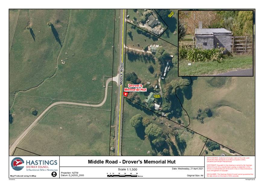
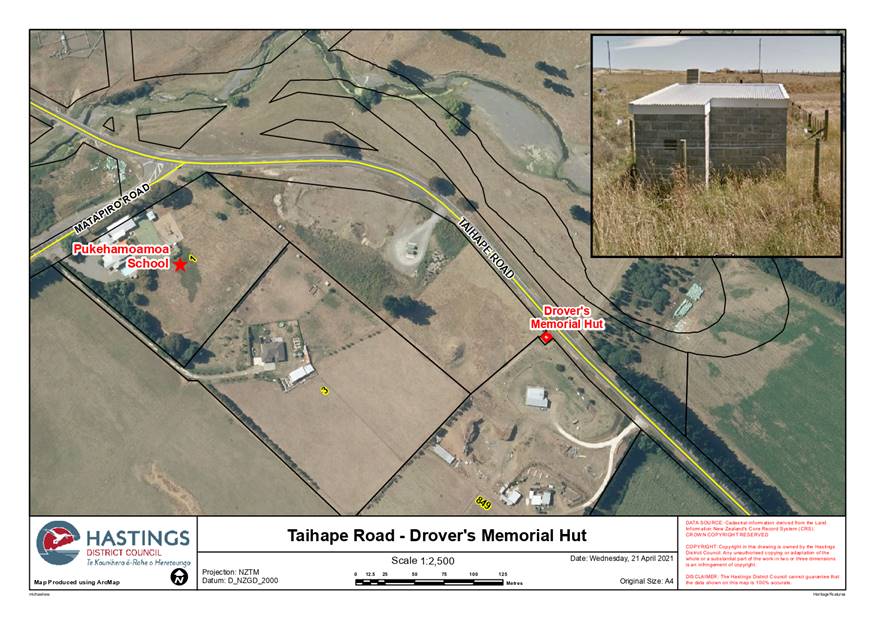
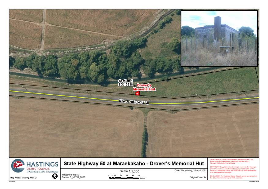
District Plan listing are the 3 Drovers Huts located on Middle, Taihape and
Maraekākaho (State Highway 50) Roads, which were built after WW2 in
commemoration of the lives of three past Hawke’s Bay Drovers killed at
war. Other suggestions thus far include the Maraekākaho Hall and
rural homesteads and memorials.
1.5 This
paper has been prepared to advise the Rural Community Board of the heritage
nomination project, receive advice or nominations on any potential rural
buildings, items or areas which might be considered and whether the Board is
aware are any known relatives of the three Drovers for whom the project and
nomination could be discussed (Poppies research and newspaper articles provide
some leads in this regard).
1.6 Once
all of the research is complete and recommendations made on the heritage
buildings, items or areas then a District Plan change will be prepared and
publicly notified. Council has a policy of not proceeding to list
heritage items in the District Plan without the landowner’s
support. Any Plan Change will also need to go to Council for its approval
to notify ahead of seeking public submissions.
2.0 Background (Te Horopaki) and Discussion
(Te Matapakitanga)
2.1 The
Resource Management Act 1991 identifies under Section 6, the protection of
historic heritage as a matter of national importance and requires Councils to
appropriately manage historic heritage through District Plans to ensure it
remains protected for future generations.
2.2 Our District has a diverse history. Historic buildings
and places are important in helping tell the stories that shaped both the
district and New Zealand. Protecting and managing Hastings’ significant
heritage items leaves a lasting legacy for future generations. Landowners and
interest groups have worked hard to preserve our heritage and share it with others.
2.3 The heritage features of the Hastings district are not
limited to the city centre; they are also found in the wider Hastings urban
area, Havelock North and throughout the rural area. Information on the
individual significant heritage buildings, areas and items currently protected
in the District Plan can be found online in Council’s recently completed
heritage browser: https://www.hastingsdc.govt.nz/hastings/about-hastings/hastings-heritage/.
2.4 The District Plan identifies and protects some
heritage, however additional items could be added to provide broader
recognition of the district’s heritage and ensure our heritage is
preserved for future generations. One of the objectives of the project is
to see additional rural, commercial and industrial heritage added to the
District Plan heritage schedule.
2.5 We are therefore looking for nominations for items our
community thinks hold heritage value and significance. Heritage
items may be identified for their aesthetic, archaeological, architectural,
cultural, historical, scientific, social, spiritual, technological or
traditional significance or value. They may also be identified for their group
and setting, landmark or design significance. Nominations can be made via the above mentioned page on Councils
website.
2.6 Council
is working alongside Historic Places Hawkes Bay on the heritage nomination
project, with Elizabeth Pishief, local Archaeologist managing the research
needed to inform the nominations. Suggested buildings, items or areas
will not go onto be researched if the property owner/s are not in in
agreement. An early letter is sent to property owners outlining the project
and that District Plan rules for historic
heritage generally require resource consent for additions and alterations so
that key heritage features are not lost and that it is likely that similar
rules would apply to any future items added to the District Plan.
2.7 Once buildings, items or areas have been researched,
recommendations made and then in some cases peer reviewed by a Conservation
Architect then a District Plan Change will follow. Nominations need to be
considered against a number of criteria to be recommended for inclusion in the
District Plan. These include meeting the definition of historic heritage
under the Resource Management Act 1991; whether the place is accessible and/or
visible; holds commemorative significance; whether it contributes through public education, to peoples’ awareness,
understanding and appreciation of the District and/or New Zealand’s
history and cultures; whether its vulnerable to deterioration, damage,
demolition or is threatened by land use activities; and/or is associated with
an event or person/s. Not all of
the project criteria need to be met to be recommended for inclusion in the
Plan. Any Plan Change adding to the heritage schedule will also
need to go to Council for its approval to notify ahead of seeking public
submissions.
2.8 Early
on in the project the 3 Drovers Huts built along droving routes and located on Middle,
Taihape and Maraekākaho (State Highway 50) Roads (see attached maps
– Attachment 1), which were built after WW2 in commemoration of
the lives of three past Hawke’s Bay Drovers killed at war and as a
memorial to historical farming practices, were identified by the project team
as potential buildings which should be added to the heritage schedule in the
District Plan. This is because they hold commemorative/memorial;
cultural/social/public esteem; and historic values. This suggestion now
has the support of a project nomination via the website.
2.9 Details
on the 3 huts and their significance are briefly outlined in the table below
and further in the document prepared as part as the Poppies Places Project and
appended to this report as Attachment 2:
|
Drovers Hut #1
(Middle Road):
|
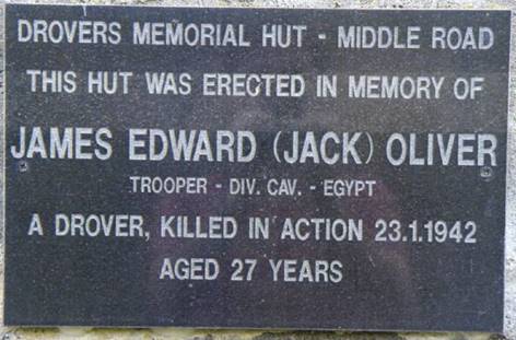
Built along a droving route in
memory of James Edward (Jack) Oliver, Trooper who enlisted in the New Zealand
Cavalry Division and former Hawke’s Bay Drover. Oliver was killed
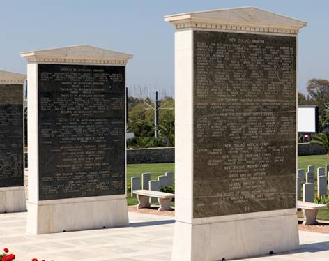
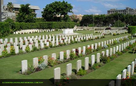
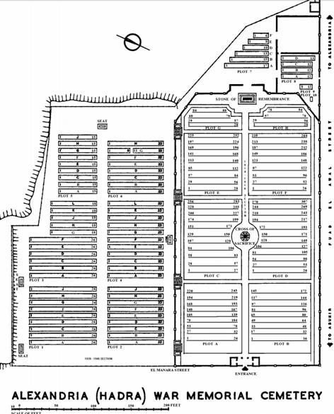
in WWII during action in Egypt on 23 January 1942 aged 26. Jack’s grave
is in the Alexandria (Hadra) War Memorial Cemetery, Egypt (Plot 1. Row B.
grave 7).
|
|
Drovers Hut #2
(Pukehamoamoa Hut/Taihape Road):
|
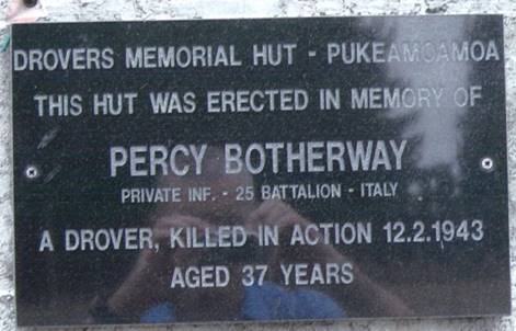
Built
in memory of Private Percy Botherway who was a drover in Hawke’s Bay
prior to enlisting. Botherway served in the New Zealand Infantry, 24th
Battalion. He was killed overseas at the age of 36 and is buried in the
Sangro River War Cemetery in Italy (plot 16, row E, grave 24; reference XVI. E. 24).
|
|
Drovers Hut #3
(Maraekākaho Road/State Highway 50):
|
Built
in memory of Lance Sergeant Wilfred James (Togo) Kirkley who prior to
enlisting was a Drover in Hawke’s Bay. Kirkley served in the 2nd
New Zealand Divisional Artillery, 5th Field Regiment who was killed as a
Prisoner of War on 9 May 1945 aged 27. He is listed on face 12 of the
Athens Memorial, Phaleron War Cemetery, Athens, Greece. No official grave is
known.
|
2.10 Two of the
huts are located on road reserve and the third at Maraekākaho is in a
freehold title which was acquired under the Public Works Act. All huts
are in the ownership of Council.
2.11 Further
suggested rural nominations include the Maraekākaho Hall, a number of
homesteads and memorials, but it is hoped that there will be more. The
Chair of the Maraekakaho Church Hall Trust Board, Johnathan Stockley, has
confirmed that the Board is supportive of this particular nomination.
With this support, the research phase of the project can commence for this
building.
2.12 A
communications plan is in place for this project which has resulted in
nominations and telephone enquiries and will continue for a significant part of
this 3 year project.
2.13 As next
steps, if the Rural Community Board has any suggested nominations then the
project team is happy to receive them. We will also be attempting to
contact relatives of the three huts as part of completing the research phase of
the project for these buildings.
|
3.0 Recommendations – Ngā Tūtohunga
That the Hastings
District Rural Community Board receive the report titled Heritage Nomination
Project dated 24 May 2021.
|
Attachments:
|
1⇩
|
Environmental Policy - Rolling Review - Heritage
Nomination Project - Drovers Maps Combined for Rural Community Board Report
May 2021
|
ENV-19-1-21-6
|
|
|
2⇩
|
Civic Treasures & Archives - Historic places,
monuments & memorials & Plaques - Poppy Places DROVERS HUTS KIRKLEY
OLIVER and BOTHERWAY
|
CTA-05-15-142
|
|
|
Item 5 Heritage
Nomination Project
|
|
Environmental
Policy - Rolling Review - Heritage Nomination Project - Drovers Maps Combined
for Rural Community Board Report May 2021
|
Attachment 1
|
|
Item 5 Heritage Nomination
Project
|
|
Civic
Treasures & Archives - Historic places, monuments & memorials &
Plaques - Poppy Places DROVERS HUTS KIRKLEY OLIVER and BOTHERWAY
|
Attachment 2
|
|
Poppy
Places – Information Sheet
|
|
|
|
|
Poppy Places
No:
|
(register
number issued by the Trust)
|
|
|
|
Title or
Place Name:
|
Drovers Huts
|
|
|
|
Controlling
Authority:
|
Hastings
District Council
|
|
Control
Reference:
|
|
|
Control
Contact:
|
Hastings
District Council – phone 06 871 5000
|
|
Location
Detail:
|
The
drovers’ huts were built along droving routes. Later the land they
stand on were vested as Road Reserve so that they would stay in Council
ownership. The huts are located:
1. Near State Highway 50,
Maraekakaho (for Sergeant Kirkley), which has a legal title located on the
Maraekakaho Road between Valley road and Kereru road and is held under the
Public Works Act.
The other two
are located on the roadside on legal road and have no title
2. By Middle Road near
Havelock North (for Trooper Oliver) - just past the entrance to 1153 Middle
Road/
3. Next to Taihape Road, just under
Pukehamoamoa School (for Private Botherway) about 300 meters before
Pukehamoamoa School (Matapiro Road turnoff).
|
|
Location Map:
|
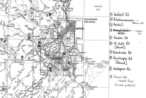
|
|
Verification:
|
Council
records note the reasons for naming the three huts and for their
construction.
|
|
|
|
The Specific Reason for naming the
place:
|
Three drovers
huts were built in memory of three Hawke’s Bay drovers who went to
World War Two and never came home:
1. Percy Botherway
2. Wilfred James (Togo)
Kirkley
3. John/James Edward
(Jack) Oliver
|
|
The Story:
|
Hawke’s
Bay Today. Monday 1st December 2008.
Friends and
families of these men, who had all been drovers before they went to war,
fundraised £160 for each hut to build three drovers huts in their
memory. The County Council donated the land and contributed to the costs of
erecting the buildings.
Percy
Botherway
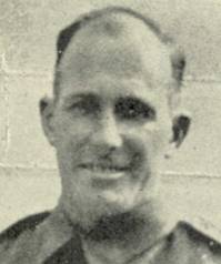
Percy
Botherway
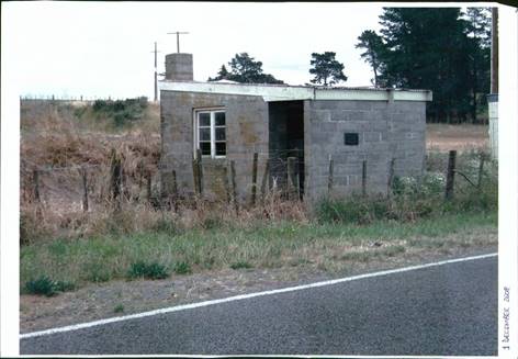
The
Drovers’ Hut erected for Percy Botherway
While the
plaque notes Percy as 37 when he died, records show he was born in 1907 and
would have been 36. He was also in the 24th Battalion.
Private
Botherway was 36 when he died of wounds in Italy on 2 December 1943, and had
been in the New Zealand Infantry, 24th Battalion, service number 402278. He
is buried in the Sangro River War Cemetery,
reference
XVI. E. 24.
Percy
Botherway was the son of George Botherway and of Sarah Botherway (nee
Briggs), of Waimate, Canterbury, New Zealand; husband of Dorothy (Dot)
Allison Botherway, of Hastings, Hawke's Bay, New Zealand. He had a son Gary,
and family members still live locally.
Headstone
records from Sangro River War Cemetery. Percy was buried in plot 16, row E,
grave 24.

“Togo”
Kirkley
Lance-Sergeant
Wilfred James Kirkley, service number 20607, served in the 2nd New Zealand
Divisional Artillery, 5th Field Regiment.
He was killed
age 27 on 9th May 1945, while a prisoner of war (in
Czechoslovakia). He is listed on face 12 of the Athens Memorial, Phaleron War
Cemetery, Athens, Greece. No official grave is known.
“Togo”
Kirkley was the son of Cedric and Elsie Myrtle Kirkley, of Hastings, Hawke's Bay.
The
Drovers’ Hut erected for Togo Kirkley.
Togo was
remembered in 2008 by Derrick Wedd (by then 85 years old), as a good swimmer
and rugby player and a very popular person in Hawke’s Bay and Hastings.
“Jack”
Oliver
Trooper John
Edward (Jack) Oliver was in the New Zealand Armoured Corp, Divisional
Cavalry, service number 12055, and was 26 years old when killed in action in
Egypt on January 23rd 1942.
Jack lived in
Twyford, Hastings. He was the son of Henry Wallis Oliver and Bessie Oliver,
of Fendalton, Canterbury.
Auckland
Museum Cenotaph and Commonwealth war records show Jack Oliver’s name as
John Edward Oliver and that he was 26 years old when he died.
Jack’s
grave is in the Alexandria (Hadra) War Memorial Cemetery, Egypt, reference
Plot 1. Row B. grave 7.
The Middle
Road hut near Havelock North (for Jack Oliver) is used by locals each month
for a Friday social hour.
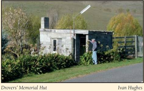
Photo from
Heritage Trails
Droving stock
could take a month from Gisborne or Feilding to the stock yards at Stortford
Lodge, Hastings. The huts were a valuable shelter for the drovers during
their long trips.
Times have
changed, and the huts are no longer used for their original purpose. The
number of stock paddocks for drovers’ use and the number of drovers
declined over the years, with road and transport safety laws now making it
almost impossible for drovers to move stock any distance over the roads.
While these
huts are a memorial to three men who lost their lives in World War II, they
also stand as a memorial to a way of life that is largely lost now in New
Zealand.
Photos from
Hastings District Council Archives
|
|
The Commemoration
|
In 1995
Hastings District Council fixed memorial plaques to the Drovers Huts and held
a memorial service to remember the three men.
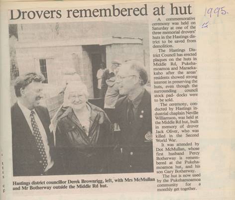
Extract from
scrapbook of Ruby Lancaster, held at Hastings District Library. Source almost
certainly Hawkes’ Bay Today.
|
|
|
|
References:
|
Hastings
District Council archives
http://www.aucklandmuseum.com/war-memorial/online-cenotaph
Commonwealth
War Graves Commission www.cwgc.org
http://www.nzwargraves.org.nz/cemeteries/athens-memorial
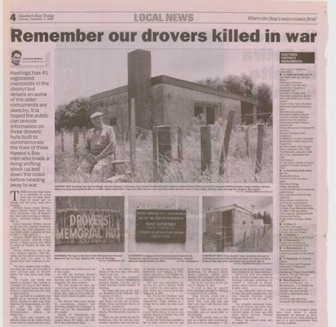
Hawke’s
Bay Today. 1 December 2008. Remember Our Drovers Killed in War. Lawrence
Gullery.
People
interested in more information on drovers can see On the Hoof: The Untold
Story of Drovers in New Zealand by Ruth E Low. Penguin. 2014
Heritage
Trails: Middle Road – Poukawa Valley (Tukituki River), published 2010.
Hastings District Heritage Trails Society Inc. Edited by Maurice Bartlett and
Ivan Hughes
Scrapbook of
Ruby Lancaster, Hastings District Library.
|
|
Author/s:
|
Chris Johnson
Cherie
Flintoff
Colin Hosford
Madelon van
Zijll de Jong
|
|
Contact
Details:
|
Hastings
District Council phone 06 871 5000
|
|
Sponsor
Details:
|
n/a
|
|
Timeline:
|
Date first
registered by the Trust:
|
00/00/0000
|
|
|
Date
completed sheet uploaded to database:
|
00/00/0000
|
|
|
|
Street Name
Type:
|
Persons
|
|
Memorial
Type:
|
Building
|
|
|
|
|
|
|
|
|
Hastings
District Council:
Hastings
District Rural Community Board
Te Rārangi Take
Report to Hastings District Rural Community Board
|
Nā:
From:
|
Rachel Stuart, Public
Spaces Planning Manager
|
|
Te Take:
Subject:
|
Reserve Management Plan
Update
|
1.0 Executive Summary
– Te Kaupapa Me Te
Whakarāpopototanga
1.1 This
report is to update the Rural Community Board on Reserve Management Plans that
are currently being prepared, specifically:
· Eskdale
Park Reserve Management Plan
· Frimley
Park Reserve Management Plan
· Review
of the Tainui, Tanner, Tauroa and Hikanui Reserves Management Plan
1.2 Council
as an administering body under the Reserves Act 1977, is obliged to prepare
Reserve Management Plans for the reserves under its management. The Act
sets out the process to be followed in preparation of management plans.
1.3 The
Parks team are managing the preparation/review of the three Reserve Management
Plans concurrently in 2021, all of which commenced in March 2021.
|
2.0 Recommendations – Ngā Tūtohunga
That the Hastings
District Rural Community Board receive the report titled Reserve Management
Plan Update dated 24 May 2021.
|
3.0 Background – Te Horopaki
Reserve
Management Plans
3.1 A
Reserve Management Plan sets out how Council will provide for the use,
enjoyment, maintenance, protection, preservation and development of a park or
reserve over a ten year timeframe. A Reserve Management Plan can either
be for an individual park or reserve or a group of parks or reserves.
The ten year plan includes a programme of capital expenditure for
development of a park or reserve.
3.2 The
plans generally consider all aspects of a park or reserve, including: access,
tracks, carparking, planting, furniture, playgrounds, buildings, signage and
recognition and protection of special features including cultural sites.
3.3 In
March 2021 Council began the process of preparing two new Reserve Management
Plans for Eskdale Park and Frimley Park, and the review of the Tainui, Tanner,
Tauroa and Hikanui Reserves Management Plan with a focus on the walking and
cycling network of the reserves. The three projects will follow similar
processes and be prepared concurrently. Frimley Park and Tainui, Tanner,
Tauroa and Hikanui reserves are urban parks, located in the suburb of Frimley
in Hastings and Havelock North, respectively. This report will focus
on Eskdale Park, given this park is located within a rural area.
Eskdale Park
3.4 Eskdale
Park is a 12.5453ha park accessed via Shaw Road off State Highway 5, north of
Napier. Eskdale Park is zoned as Open Space (OS2-09) in the Operative
District Plan and classified as Recreation Reserve pursuant to the Reserves Act
1977. The park is popular for picnics and dog walking due to the large
natural open space and access to Esk River. The park has a number of
mature trees, children’s playground, cricket pitch, two toilet
blocks. Part of the park is currently leased for grazing. Eskdale
Park is currently managed under the District Wide Reserve Management Plan.
Pathway to
Reserve Management Plan process
3.5 Hawke’s
Bay Mountain Bike Club (HBMBC) has operated mountain bike trails on privately
owned Pan Pac Forest land since the 1990s. Due to impending
commercial operations on their current trail site, HBMBC have negotiated a 25
year lease with Pan Pac to relocate to the Waipunga and Tait blocks, opposite
Eskdale Park.
3.6 In
May 2020 HBMBC was granted resource consent to establish the new trail network
in privately owned Pan Pac land, with access and carparking off Waipunga
Road. In addition, HBMBC have also identified their desire to access
their new trail network from Eskdale Park, as the access from Waipunga Road
would require a 2km uphill ride from the carpark to the start of the trails.
3.7 While
no formal application had been received, in July 2020 Council discussed the
HBMBC proposal with the Eskdale Park Care Group at a planting day in the
park. Given concerns raised by some members of the community regarding
potential change to the park, Council subsequently undertook a public consultation
process with a blank canvas, including a My Voice My Choice survey and an
Open Day. There was significant concern raised by the community at the
Open Day, following which Council held meetings with key stakeholders and
people who had volunteered at the Open Day to be part of a working party.
3.8 The
meetings with key stakeholders and the working party were held in November
2020, at which the general consensus was to prepare a Reserve Management Plan
for Eskdale Park. On 8 December 2020 Council authorised officers to
commence the preparation of a Reserve Management Plan and the process began on
6 March 2021 with publication of the intention to prepare the Reserve
Management Plan for Eskdale Park.
4.0 Discussion – Te Matapakitanga
Management Plan Process
4.1 The
process for preparation or review of a Reserve Management Plan is set out in
Section 41 of the Reserves Act 1977. Council is following this process
for Eskdale Park, as well as the other Reserve Management Plan projects.
In addition, officers have added a third community engagement step to ensure
consultation with the community is as robust and comprehensive as
possible. The process for the preparation of the Eskdale Park Reserve
Management Plan is included in Attachment 1.
4.2 The
process moving forward is as follows:
· Preparation
of key themes and concepts based on feedback gathered during the first stage of
community engagement. Key stakeholders will be invited to participate in
this stage.
· Key
themes and concepts presented to the community in a second round of community
engagement, to test Council is on the right track with direction of the plans.
· Preparation
of the Draft Plan, engaging relevant specialist input and undertaking
stakeholder workshops
· Workshop
with the Eco District Subcommittee to consider the Draft Plan
· Council
adopts the Draft Plan for consultation purposes
· Public
notification of the Draft Plan for a period of two months
· Hearing
of submissions and any required amendments
· Obtain
Minister of Conservation approval
· Adopt
reserve management plan
· Monitor
and review plan as required
Community Engagement and Specialist
Input
4.3 The
first stage of community engagement was undertaken between 6 March and
23 April 2021. To ensure the views of the community were
captured as widely as possible, FOLKL, an independent research consultancy were
engaged to undertake the first stage of community engagement and to gather data
regarding usage of Eskdale Park. FOLKL have undertaken an extensive
community engagement process, including:
· Design
of the survey which was available on Council’s survey portal My Voice My
Choice, at Eskdale Park, at the Bay View Four Square, Napier, Taradale,
Hastings, Flaxmere and Havelock North libraries and Council’s customer
service centre.
· Facilitated
a number of meetings with key stakeholders, including: representatives of the
Clark family; Friends of Eskdale Park; HBMBC; Rosy Hiha; Hukarere Girls’
College; Eskdale School; Eskdale Park Campground.
· Undertook
intercept interviews at Eskdale Park.
· Facilitated
a Coffee in the Park day where members of the public could discuss their ideas
and suggestions for the park.
· Undertook
door knocking around local businesses in the Eskdale area.
4.4 As
part of standard practice during the first stage of community engagement for a
Reserve Management Plan the following methods were also used to ensure wide
community awareness of the commencement of the process, and how they could be
involved:
· Signs
at entrance to Eskdale Park (with surveys attached);
· Social
media and print media advertising;
· Individual
letters requesting feedback to landowners and occupiers within a 2.5km radius
of the park (over 1300 residents within both Hastings District Council and
Napier City Council boundaries)
· Letters
to interested parties including the Department of Conservation, Kiwirail, Waka
Kotahi, Biodiversity Hawke’s Bay, New Zealand Walking Access Commission,
Heritage Hawke’s Bay, Heritage New Zealand, Landmarks Trust and Sport
Hawke’s Bay.
4.5 At
the close of Stage 1 consultation, over 1000 pieces of feedback had been
received.
4.6 In
addition, FOLKL gathered data on usage of Eskdale Park to gain a clear
understanding of use of the park. Officers also engaged historian Michael
Fowler to prepare a history of the park and Archaeology Hawke’s Bay to
undertake preliminary archaeological screening of the park, to inform the
Reserve Management Plan.
5.0 Options – Ngā Kōwhiringa
Option One - Recommended Option -
Te Kōwhiringa Tuatahi – Te Kōwhiringa Tūtohunga
5.1 This report is for
information purposes only and it is recommended that the Committee receive this
report for information purposes.
6.0 Next steps – Te Anga Whakamua
6.1 The
report on the first stage of community engagement is due to be completed in the
coming months. Following analysis of this information, in conjunction
with the community key themes and concepts will be prepared for Eskdale
Park. These will be released for a second stage of community
engagement. Officers will keep the committee informed of progress.
Attachments:
|
1⇩
|
RMP timeframe RCB 240521
|
CG-16-7-00051
|
|
|
Item 6 Reserve
Management Plan Update
|
|
RMP
timeframe RCB 240521
|
Attachment 1
|
Hastings
District Council:
Hastings District
Rural Community Board
Te Rārangi Take
Report to Hastings District Rural Community Board
|
Nā:
From:
|
Vicki Rusbatch, Senior
Advisor Democracy and Governance Services
|
|
Te Take:
Subject:
|
Report on attendance at
the 2021 NZ Community Boards Conference
|
1.0 Purpose and summary - Te Kaupapa Me Te Whakarāpopototanga
1.1 The purpose of this
report is to inform the Board that RCB Chair Nick Dawson and Member Sue Maxwell
will provide verbal reports on their attendance at the Community Boards Conference
held in Gore on 22-24 April 2021.
1.2 The 1 March meeting of
the Rural Community Board resolved to send Board Chair Nick Dawson and Member
Sue Maxwell to the Conference.
1.3 The report concludes
by recommending that the verbal reports be received.
|
2.0 Recommendations – Ngā Tūtohunga
A) That the
Hastings District Rural Community Board receive the report titled Report on
attendance at the 2021 NZ Community Boards Conference dated 24 May 2021.
B) That the
Board receive the verbal reports from Board members Nick Dawson and Sue
Maxwell who attended the 2021 NZ Community Boards Conference.
|
Attachments:
There are no attachments for this report.
Hastings
District Council:
Hastings
District Rural Community Board
Te Rārangi Take
Report to Hastings District Rural Community Board
|
Nā:
From:
|
Jackie Evans,
Manager:Democracy and Governance
|
|
Te Take:
Subject:
|
Consideration of
Establishment of Maori Wards for 2022 Elections
|
1.0 Purpose and summary - Te Kaupapa Me Te Whakarāpopototanga
1.1 The purpose of this
report is to inform the Board of a proposal to establish Maori Wards for the
2022 local authority elections. Attached for information is a copy of the
report being considered at an Extraordinary Council Meeting on 18 May.
1.2 The Extraordinary
Council Meeting on 18 May resolved as follows:
A) That
the Extraordinary Council Meeting receive the report titled Consideration
of the Establishment of Māori Wards for 2022 Local Authority Elections
dated 18 May 2021.
B) That
in accordance with Section 78 of the Local Government Act 2002 Council agrees
that the communication plan, timetable, events and feedback responses provides
sufficient information on the views and preferences of Māori and the wider
community to enable the Council to reach a decision on whether to establish
Māori Wards in time for the 2022 local authority elections.
C) That
Council resolves, in terms of Section 82 (3) of the Local Government Act 2002,
that the principles set out in that section have been observed in such a manner
that the Hastings District Council considers, in its discretion, is appropriate
for the decisions made in the course of this meeting.
D) That
the results of the community engagement, comments of Māori and the broader
community set out in the report be received and considered in reaching a
decision on the establishment of Māori Wards.
E) That
Council establishes Māori Wards in the Hastings District for the 2022
triennial election.
F) That
the Council approve a budget of $80,000 in the 2021/22 financial year to cover
the costs for project management and Special Consultation Procedure for a
representation review to commence in 2021.
1.3 Following the 18 May
Council Meeting, the Board will receive a further update on the Council’s
decision and any potential implications on the rural area.
|
2.0 Recommendations – Ngā Tūtohunga
That the Hastings
District Rural Community Board receive the report titled Consideration of
Establishment of Maori Wards for 2022 Elections dated 24 May 2021.
|
Attachments:
|
1⇨
|
Report to Extraordinary Council Meeting 18 May 2021 -
Consideration of the Establishment of Māori Wards for 2022 Local
Authority Elections
|
CG-16-7-00049
|
Document 3
|
Hastings
District Council:
Hastings
District Rural Community Board
Te Rārangi Take
Report to Hastings District Rural Community Board
|
Nā:
From:
|
Danny McClure, Solid
Waste Operations & Contract Manager
|
|
Te Take:
Subject:
|
Rural Recycling Update
|
1.0 Purpose and summary - Te Kaupapa Me Te Whakarāpopototanga
1.1 The purpose of this
report is to provide the Rural Community Board with a general update on the
rural recycling facilities over the 2020/2021 summer/autumn period.
1.2 The decision-making
framework to temporarily close rural recycling facilities when incidents of
misuse occur has not been used during this quarter.
All sites; Tūtira, Waipātiki,
Pukehamoamoa, Maraekākaho, Poukawa and Waimārama, have been fully
operational over the summer/autumn period.
1.3 The Pukehamoamoa
facility continues to be challenging with 2 instances of significant
contamination.
1.3.1 First instance 3 cubic metres of refuse
removed at the recycling contractors sit and documented with mail found and
letters sent to the respective residents – images below for reference
1.3.2 Second instance 1 cubic metre of refuse
removed at the recycling contractors site and documented with mail found and
letters sent to the respective residents – images below for reference
1.3.3 Constructive discussions with the community
have started, highlighting the option of having this site gated and only open
for set hours during the day, and a key for the gate being held at the school
for residents/community to access after-hours.
1.3.4 Gates have been gifted by a Pukehamoamoa
resident and HDC will look at getting this applied to the site and providing a
lock and chain for the community to manage the opening/closing and access to
site.
1.4 Recent Tutira site
contamination in the plastics/cans section of the bin has been highlighted to
the Tutira School to make reference in their school newsletter with images (as
below) for the community to be aware and report any negative treatment of the
site to HDC.
1.4.1 

1.5 A resource consent
application for the proposed new Te Pōhue facility has been submitted in
March for processing. No further information is required and it is expected
that a decision regarding who is to be notified of the application will be made
w/e 7th May 2021 with a site visit 4th May 2021.
1.5.1 The two immediate affected party consents
were not returned, with one resident stating that they would not sign off in
agreement due to perceived adverse use and noise and no response was received
from the Te Pōhue School Board of Trustees.
1.6 Generally, all of the
facilities were used correctly over summer/autumn period with only major dumping
or contamination issues reported from the Pukehamoamoa site.
1.7 There was another
attempt by an unknown party to remove the western side platform from the
Waimārama facility, no damage to the steps in this instance. This
was repaired as soon as it was reported to Council.
1.8 The data below
provides a breakdown of the volumes and servicing of the facilities over the
summer.
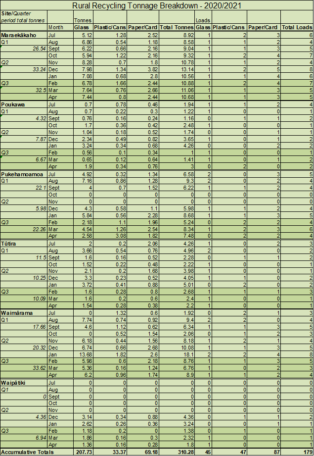
1.9 New sign artwork is up
at each of the rural recycling sites ensuring all information is now up to
date.
|
2.0 Recommendations – Ngā Tūtohunga
That the Hastings
District Rural Community Board receive the report titled Rural Recycling
Update dated 24 May 2021.
|
Attachments:
There are no attachments for this report.
Hastings
District Council:
Hastings
District Rural Community Board
Te Rārangi Take
Report to Hastings District Rural Community Board
|
Nā:
From:
|
Danny McClure, Solid
Waste Operations & Contract Manager
|
|
Te Take:
Subject:
|
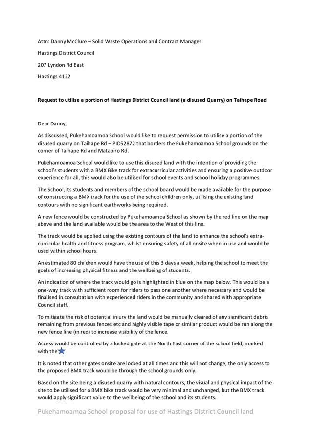
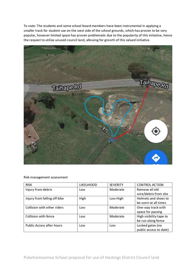
Pukehamoamoa School -
Request to Use Disused Quarry
|
1.0 Purpose and summary - Te Kaupapa Me Te Whakarāpopototanga
1.1 The purpose of this
report is to inform the Rural Community Board about Pukehamoamoa School’s
request to utilise a portion of the old unused quarry on Council-owned land
(LOTS 1 2 DP 26545 BLK V HERETAUNGA SD) for a BMX track for the exclusive use
by school pupils.
1.2 The school principal
has provided officers with an overview of use which includes a Health and
Safety Risk Assessment and this will form the basis of the discussion.
1.3 Council officers will
draft an agreement to formalise the conditions of land use and ensure all
overarching Health and Safety requirements are being applied. All
appropriate officers will be included in this process.
|
2.0 Recommendations – Ngā Tūtohunga
A) That
the Rural Community Board receive the report titled Pukehamoamoa School -
Request to Use Disused Quarry dated 24 May 2021.
B) That
the Rural Community Board recommend that Council officers be delegated
responsibility to finalise and formalise an agreement with Pukehamoamoa
School to allow access to and use of the former quarry (LOTS 1 2 DP 26545 BLK
V HERETAUNGA SD).
|
Attachments:
|
1⇩
|
Pukehamoamoa School - Request to use HDC Quarry for
BMX track
|
SW-28-2-21-11
|
|
|
Item 10 Pukehamoamoa
School - Request to Use Disused Quarry
|
|
Pukehamoamoa
School - Request to use HDC Quarry for BMX track
|
Attachment 1
|
 Te Hui o Te Kaunihera ā-Rohe o Heretaunga
Hastings
District Council:
Hastings
District Rural Community Board
Te
Rārangi Take
Report to Hastings District Rural Community Board
|
Nā:
From:
|
Adam Jackson,
Transportation Operations Manager
|
|
Te Take:
Subject:
|
Rural Transportation
Activities Report
|
1.0 Executive Summary – Te Kaupapa Me Te
Whakarāpopototanga
1.1 This
report is to update the Rural Community Board with the Rural Transportation
Programmed Project Status and Activities Report.
1.2 This report concludes by recommending that the report be received.
|
2.0 Recommendations – Ngā Tūtohunga
That the
Hastings District Rural Community Board receives the report titled Rural
Transportation Activities Report dated 24 May 2021.
|
3.0 2020/2021 Major
Works Programme
3.1 The
2020/21 financial year is the final portion of the 2018-21 LTP programme.
3.2 Projects
able to be completed in 2020/21 are often a result of programme changes during
the first 2 years of the LTP programme and that has been the case during this
LTP.
3.3 The
following is the status of the final Area Wide Pavement Treatment programme for
the 2020/21 financial year.
|
Road
|
Section
|
Status/Comment
|
|
Kererū Road
|
Kererū Road – Section 2
|
Construction 100% complete. Small shoulder areas
needing sealed.
|
|
Kererū Road
|
Kererū Road – Section 3
|
Design complete. Construction on hold until 21/22
season
|
4.0 Bridge Update
4.1 Mangatahi
Low Level (Mangatahi Road) bridge replacement works are nearing completion with
road surfacing work yet to be done. Expected completion date is 14 June 2021.
4.2 Kuripapango
bridge strengthening works are expected to be completed ahead of schedule by
mid-May 2021. Everyone involved have worked very collaboratively and have been
committed to getting the work done on or ahead of schedule which has paid off.
4.3 Rissington
bridge vertical clearance upgrade designs have been completed. The material
required for the works will be purchased this financial year. The upgrade will
take place in the next financial year following consultation.
4.4 The
next round of bridge evaluations are nearing completion with a finish date by
end of June. There are at least 4 structures expected to go into construction
next year.
5.0 Provincial Growth
Fund Projects (PGF)
5.1 PGF
has allocated $1.4M for roading projects in DRA2. These are 100% funded by the
PGF, so do not have any impact on rates. These projects are ones that were
considered shovel ready, and have been assigned to Contractors to start in Q3
of 2020. The projects are:
|
Road
|
Project
|
Status/Comment
|
|
Tukituki Road
|
AWPT
|
Complete
|
|
Taihape Road
|
Passing Lanes 1-4
|
Complete
|
|
Taihape Road
|
Bridge Guardrail Package 1.
|
Tender has been let and works have commenced.
Project is due for completion by end of June.
Delays to this project were realised after tender
acceptance but HDC are progressing with designs to do more guardrail work on
Taihape Rd bridges in 2021/22 financial year also.
|
6.0 State Highway 5
and State Highway 51 Speed Limit Submission
6.1 Hastings
District Council made a submission to Waka Kotahi NZ Transport Agency’s
speed limit proposals. A copy of this submission is attached to this report as Attachment
1.
7.0 Works Update
7.1 Attachment
2 provides the Rural Community Board with a photographic snapshot of
activities undertaken between March 2021 and May 2021.
Attachments:
|
1⇩
|
Transport (USE ROAD CONTAINER FOR INDIVIDUAL ROADS) -
Roads General (See notes) - State Highway Speed Limits Submission to Waka
Kotahi
|
TR-8-21-10012
|
|
|
2⇩
|
Transport (USE ROAD CONTAINER FOR INDIVIDUAL ROADS) -
Roads General (See notes) - 11_RCB Photos - March 2021 to April 2021
|
TR-8-21-10013
|
|
|
Summary of
Considerations - He Whakarāpopoto Whakaarohanga
|
|
Fit
with purpose of Local Government - E noho hāngai pū ai ki te
Rangatōpū-ā-Rohe
The Council is required to give effect to the purpose of
local government as set out in section 10 of the Local Government Act 2002.
That purpose is to enable democratic local decision-making and action by (and
on behalf of) communities, and to promote the social, economic,
environmental, and cultural wellbeing of communities in the present and for
the future.
Link to the Council’s
Community Outcomes –
Ngā Hononga ki Ngā Putanga ā-Hapori
This report promotes the performance of
regulatory functions for the purpose of providing safe, reliable and
efficient transport networks.
|
|
Māori
Impact Statement -
Te Tauākī Kaupapa Māori
No known impacts for tangata whenua over
and above the impact on the rural district as a whole:
|
|
Sustainability
- Te
Toitūtanga
This is a progress report and
sustainability issues are not addressed.
|
|
Financial
considerations -
Ngā Whakaarohanga Ahumoni
The works identified within this
report are within existing budgets.
|
|
Significance
and Engagement -
Te Hiranga me te Tūhonotanga
This report has been assessed under the Council's
Significance and Engagement Policy as being of minor significance.
Individual projects will have been addressed under the significance and
engagement policy during the planning and decision making phase of those
projects.
|
|
Consultation
– internal and/or external - Whakawhiti Whakaaro-ā-roto / ā-waho
No consultation is required as part of
this report.
|
|
Risks
Risk management and mitigation issues have been addressed
in project planning and organisational health and safety policies.
|
|
Rural
Community Board –
Te Poari Tuawhenua-ā-Hapori
The Rural Community Board will have an
interest in the operations and transportation activities within the DRA2
rating area.
|
|
Item 11 Rural
Transportation Activities Report
|
|
Transport
(USE ROAD CONTAINER FOR INDIVIDUAL ROADS) - Roads General (See notes) - State
Highway Speed Limits Submission to Waka Kotahi
|
Attachment 1
|
If calling ask for Nigel
Bickle
File Ref: TR-8-21-10012
7 May
2021
Waka Kotahi NZ Transport Agency
National Office
PO Box 6995
Wellington 6141
SH5 and SH51 Hawke’s Bay speed limit consultation
Thank you for the opportunity to submit on your two speed
limits proposals. While, our submission relates to both SH5 and SH51, we
have chosen to elaborate on SH5 as this proposal has significant impacts on the
social and economic performance of our and neighbouring regions.
SH5 Speed Limit Submission
As you will be aware HDC has been a strong supporter of
speed management when applied appropriately and following extensive engagement
of affected parties. Within Hastings we have adopted speed management
approaches across a large part of our network and only recently, early 2021, we
implemented speed reductions across approximately 70 roads within
Hastings. This approach demonstrates our commitment to Road to Zero and
shows our willingness to utilise speed management as part of the toolbox in
achieving this outcome.
However, with respect to the proposed speed limit reduction
on SH5 we oppose this proposal as it currently stands. We
have real objections to the process adopted by Waka Kotahi and the
recommendations made and we are concerned that there is inadequate evidence
and/or analysis to support the proposals. Our concerns are detailed
within this letter and are summarised as follows:
· We are concerned that the strategic importance of this link
has been undervalued and not adequately considered in determining a safe and
appropriate speed for SH5. We believe the impacts of the proposed change
have been significantly underestimated in determining the proposed outcome.
· In reviewing the technical assessments completed we have
concerns with the desk top nature of the analysis and the absence of any site
visits, validations and assessments. We are particularly concerned with
the lack of analysis of the recorded crashes and believe without this level of
assessment it is impossible to conclude that the proposed intervention is
appropriate and even more impossible to have confidence that it will drive the
desired safety outcomes.
· We strongly believe that the approach to public
consultation and engagement is far from acceptable and does not accord with
Waka Kotahi’s own guidelines. We believe there are significant
issues associated to the approach adopted by Waka Kotahi and that the public
and affected parties have not been afforded appropriate engagement and input to
the process.
· We have heard our community loud and clear and believe that
there is almost no support for the proposed speed limit reduction. The
concerns raised by the public are numerous and consistent and demonstrate a
lack of understanding from Waka Kotahi as to the perceptions and expectations
of the local community and the wider affected stakeholders.
· We remain concerned with the significant under investment
in infrastructure along SH5 and believe that this under investment has directly
contributed to the poor safety outcomes present on this route. There is a
need for significant and prompt action to upgrade this route to a level
befitting of its Regional Strategic nature.
· We believe that the only option to address the poor safety
record of SH5 is to progress a more comprehensive corridor study to better
define and evaluate the problem and to ultimately develop an intervention
strategy that takes a holistic approach and achieves multiple outcomes for
safety, efficiency, resilience and accessibility.
Strategic Importance of Link
As you are aware the SH5 (Napier to Taupo) corridor is a
122km long Regional Strategic corridor located in the Taupo and Hastings Districts.
The corridor has relatively flat and straight/moderately curved sections at
either end where open pastures and forestry blocks are prevalent and more
constrained winding sections within the middle portion of the route.
You will also be aware that the SH5 corridor plays a
significant role in the economic contribution to both Hawkes Bay and Waikato
through its critical roles in both tourism and freight transport. Forming
part of the ‘Thermal Explorer Highway’ SH5 accommodates national
and international visitors travelling between the tourism hotspots of Rotorua,
Taupo and Hawkes Bay.
From a freight perspective this route provides a critical
link to the forestry and agricultural operations located along the route and at
either end of the route in both Waikato and Hawkes Bay. It provides a key
linkage for exports via the Napier Port and forms part of the critical courier
network serving the large distribution centres within the central north island
(notably Taupo).
With observed daily traffic volumes of over 4,000 vehicles
per day and with 20% heavy vehicle representation, any proposed reduction in
speed on this route could have significant economic implications for local and
national industry. We are concerned that these impacts have not been
appropriately nor adequately assessed.
Within the consultation flat sheet associated to this proposal,
Waka Kotahi identify an increase in mean travel time of 41 seconds. This
travel time impact has been reiterated by Waka Kotahi on numerous occasions
within local and national media in response to growing public concerns and
outcry associated to this proposal. We share similar views to a number of
those submitters in that the suggestion of a 41 second impact is misleading and
does not accurately reflect the true travel time impact of the proposal.
The 41 second impact seems to have been coarsely calculated
based on the assumption that the proposal will simply reduce the average speed
from its current number of 81km/h to the proposed speed limit of 80km/h –
a 1km/h impact. This would only be true if current users were able to
travel the extents of the route at a steady speed of 81km/h. Given the
winding nature of the route this is not possible, meaning current speeds
fluctuate far above and far below the average on any given route section.
There are numerous tight corners and bends along the route which dictate
traffic speeds well below the proposed 80km/h speed limit with many examples of
bends signposted with advisory traffic speeds between 35km/h and 75km/h.
Traffic travelling through these bends will currently reduce speeds well below
the average 81km/h observed mean speeds meaning that they must be travelling
the straighter sections at speeds far above this number (in order for the
average to be 81km/h).
Should the proposal progress, there is unlikely to be any
change in travel speeds around the tighter bends along the route given traffic
is already slowing through these sections. As such, the majority of the
impact will be on the straighter sections of the route where travel speeds will
need to reduce far more to meet the 80km/h speed limit. As a result the
mean operating speed should be expected to decrease well below the 80km/h
posted speed limit (given you can’t travel this speed around the winding
sections of the route). This is contrary to the information Waka Kotahi
has provided to the public and therefore doesn’t bear any resemblance to
the true impacts of the proposal and doesn’t accurately reflect the real
travel time impact of the changes.
Furthermore, having reviewed both the technical report
prepared by Urban Connection and the associated Internal Speed Limit Review
documentation prepared in support of this proposal we have found no evidence
nor suggestion of a 41 second impact associated to this proposal. To the
contrary, the internal documentation notes a travel time impact of between 5:47
and 18:22 minutes depending on whether you assess the impact against the
current mean speed or the current speed limit. Whist we recognise that
the internal paper includes consideration of the impact associated to all 6
route sections (and not solely sections 2 to 5), it is reasonable to conclude
from this information alone that the impact associated to sections 2 to 5 will
be far greater than the 41 seconds suggested in the consultation materials
(given this makes up over 60% of the total route length).
As a result, we know that the true impact of the proposal
has potential to result in significant and detrimental impacts to local and
national industry and economies and we remain concerned that these
haven’t been adequately assessed in forming a view on the ‘safe
and appropriate’ speed for SH5.
Waka Kotahi Technical Assessment
We have reviewed both the Technical Assessment Report
completed by Urban Connections and the Internal Engagement documents. We
note that all assessments have been undertaken via a desktop study only with no
site visits/assessments completed. Within the Executive Summary of the
Technical Assessment report Urban Connection clearly recommend a site visit to
‘verify and confirm the results of the desktop assessment’.
However, the report goes on to say that NZTA determined ‘no further
technical assessment was required’.
HDC are perplexed as to how a proposal of this scale with
anticipated significant impacts on both the local community and national
industries could be progressed without visiting the site. Site
assessments and validation forms an important part of the speed setting process
and is critical to ensure that the desktop findings and recommendations suit
the receiving environment. Furthermore, the site investigation should
help determine more accurately whether speed management is the appropriate
solution or if more suitable infrastructure responses are required to target
specific risks.
Waka Kotahi have stated on numerous occasions, within both
the consultation documentation and the subsequent responses to media concerns,
that speed management is just one piece of the puzzle in achieving improved
road safety on SH5. We agree wholeheartedly with this sentiment but
question as to how Waka Kotahi have deemed it appropriate to progress a speed
limit reduction in isolation without undertaking site visits to test whether
infrastructure responses are more applicable to the risks observed along the
route.
Further to the above we also note that the vast majority of
the technical assessment seems to come down to just 3 metrics. Primarily
the team have considered travel speeds, corridor risk and crash history.
Unfortunately, the crash history has been assessed at only a macro level with
no detailed analysis of the individual crashes. As such, the relationship
between the travel speeds and the crash outcomes specific to this corridor are
not well defined and have therefore not formed part of the assessment for the
corridor. HDC are concerned that the absence of this level of detail
means that it is impossible to infer that the proposed speed limit reduction
will achieve the safety outcomes desired.
As indicated above HDC have completed a number of speed
limit reviews in recent years with the most recent reviews resulting in speed
limit changes across almost 70 roads within Hastings District – as such
we are well placed to understand the level of assessment justified to inform
the best outcomes. In completing the HDC review we conducted detailed
technical assessments at both a macro and micro level to better understand the
current crash trends which ultimately helped us to understand the need for, and
associated benefit of, speed limit reductions. During the consultation
exercise Waka Kotahi responded to HDC and ‘congratulate(d) Council on the
quality of the proposal, the ease of navigation and simple access to
explanatory notes. It is one of the best presented proposals Waka Kotahi
has received’. This acclaim came from our transparent approach of
comprehensively assessing each route and reviewing historic data in detail to
ensure the proposed solution addressed the inherent risks. Where crashes
not associated to operating speed had erroneously driven Safe and Appropriate
Speed (SAAS) recommendations we were able to clearly identify these and ensure
due consideration was given to the appropriate SAAS in light of the crash
risks.
Given the scale of the proposed change and the large and
negative implications it will have on local communities and national industries
we remain concerned that the level of technical assessment followed for SH5 is
not fit for purpose. It is impossible to confidently conclude that the
proposed treatment is the most appropriate solution for this corridor given the
lack of evidence presented and the absence of detailed analysis of the
available information. We believe Waka Kotahi has a duty to reconsider
their position and invest additional time in a more detailed and comprehensive
assessment of the corridor in order to develop an integrated corridor response
which adequately balances the safety and economic drivers for the route through
a combined infrastructure and speed management response.
Consultation and Engagement Approach
HDC have serious concerns with regards to the lack of
consultation and engagement completed with key stakeholders and affected
parties. Whilst HDC (and the Regional Transport Committee) were afforded
a very brief presentation by Waka Kotahi on 8th April and 9th
April respectively, this cannot be considered engagement by any means.
Concerns and questions raised by each party were left unanswered prior to the
public consultation commencing just 3-4 days later. In effect this presentation
was simply a heads-up in regard to what was coming. While appreciated, it was
not consultation, nor should it be relied on as being consultation. In
addition, it is not clear whether any of the broader key stakeholders were
engaged prior to the public consultation.
Waka Kotahi’s own guidelines are clear on the
expectations and requirements associated to the setting of speed limits but in
this instance it appears short cuts have been taken. The Technical
Assessment completed by your consultants confirms the classification of the
route as a combination of ‘Engineer up’ and ‘Challenging
Conversations’. The ‘Challenging Conversations’
classification highlights that a speed limit reduction may be warranted and
that it is highly likely to be contentious and require extensive evidence and
engagement in order to achieve acceptance from affected parties.
Section 2.1.5 of the Speed Management Guide is clear in
stating that ‘lowering limits can often be challenging… careful and
sometimes extended community engagement and consultation is
warranted’. The guide goes on to provide extensive examples of
effective community consultation and engagement and recognizes that
‘gaining community engagement in and gaining support for speed management
is crucial’.
Waka Kotahi have simply ignored this advice and not
implemented the recommended approach to speed limit setting as detailed within
the Speed Management Guide. Rather, Waka Kotahi have shown poor judgement
in rushing through this public consultation without effectively engaging with
the local community and other affected stakeholders. This risk was
clear and was even recognised by the Waka Kotahi team during the internal
review which, in Section 8.9, captures the sentiment that
‘Point(s)…above reflects the need to ensure robust engagement is
completed prior to formal consultation’.
Given the above it’s quite frustrating to read the
concluding recommendation from the internal review to ‘go straight to
consultation on SH5, with some light, targeted engagement immediately prior.
Reflecting the desire to have an expedited process…’. Waka
Kotahi have seriously misjudged the public’s position with respect to
this proposal and in shortcutting Waka Kotahi own recognised approach to speed
management Waka Kotahi have removed the opportunity for meaningful engagement
with those most affected by the changes.
HDC believe the consultation and engagement approach
adopted by Waka Kotahi is inappropriate and unacceptable. Arguably, due
process has not been followed and we encourage Waka Kotahi to seriously
consider their position prior to progressing these recommendations any further.
Community Feedback
The local community and other affected parties have made
their voices clear during this consultation process and it is apparent they are
not satisfied with the proposal as it stands. There is real resentment
across these affected parties and a belief that they’re not being heard
and their requests are being ignored. Feedback via the Te Pohue community
meeting, Waka Kotahi social pinpoint site and the HDC Facebook page in addition
to specific emails and letters to Councillors shows a very consistent
message. In addition, media coverage and stories from local affected
parties follows similar themes and shows a lack of support for the proposal and
a real desire for infrastructure responses to counter the ongoing lack of investment
in this critical transport link. Below provides just a short synopsis of
some of the feedback received via various channels and demonstrates the
consistent concerns of the local communities and other affected parties:
· Te Pohue Community
o The community told us loud and clear that the issue was not
speed and that they want Waka Kotahi to demonstrate that they are investing in
the road.
o An 80km/h speed limit will make passing of vehicles (even
at passing lanes) impossible and increase frustration and therefore increase
risky overtaking.
o The community strongly contests the suggestion that this
change will add only 41 seconds to travel times with a heavy vehicle driver
noting it would reduce his income by 25% due to a reduction in the number of
trips he could make.
· Hawkes Bay Today
o Chris Whiteman, who travels the route once a month
commented that the speed limit reduction will frustrate people and will make
the situation worse (Published 28th April 2021).
o Sandra Hazelhurst, Mayor, Hastings District Council; Tania
Kerr, Deputy Mayor, Hastings District Council; and Martin Williams, Chair,
Hawke’s Bay Regional Transport Committee have commented as follows:
o State Highway 5 is literally our lifeline connection to the
north, and a critical freight route on which the regional economy depends.
o Speed reduction on State Highway 5 is not the right answer
when the real issue is years of under investment in undeniably essential
improvements to the corridor.
o We cannot let road safety be used as an excuse to avoid the
real problem here, at everyone’s expense but the Transport
Agency’s, and to the detriment of our regional economy.
o The consultation process has been “fast
tracked”, cutting out a public engagement step, so that the move can be
Gazetted by Government after “formal consultation” closes on 9 May
2021.
o Councillor Malcolm Dixon commented that reducing speeds on
SH5 would increase frustration and that major maintenance and realignment is
what’s needed (Published 30th April 2021).
o The father of a daughter who died in a car crash on SH5
called the proposal a band aid solution to open-heart surgery. Mr Sanders
referenced the poor condition of the road as the major contributor to crashes
and a speed limit change would not deal with the problem (Published 3rd
May 2021).
· Hastings District Council Facebook Page
o Lack of investment over the years and traffic growth is the
primary reason for accidents.
o Reducing the speed limit won’t help, adequately
maintaining and improving the road and more overtaking areas would provide a
better outcome.
o Lowering the limit won’t fix the problem, it’s
just a band aid.
o Waka Kotahi need to improve the roads and educate drivers.
· Waka Kotahi Social Pinpoint
o Lowering the speed limit will cause frustration and result in
drivers taking more risks (a theme repeated consistently across submitters).
o SH5 has been neglected and the evidence and impact is
obvious and significant.
o Commentators stating that they’ve never seen a State
Highway in such poor condition (with so much damage).
o The road plays a vital role in the economy of Hawkes Bay
and the broader North Island and the proposed speed reduction will have
significant and detrimental impacts on travel times and therefore freight
efficiency concluding with a negative economic impact for New Zealand.
o Regardless of whether the speed limit is reduced or not,
the road is in desperate need of investment to address the long term
deterioration that has been witnessed along this route. Waka Kotahi
should take a more comprehensive approach to this corridor which better
balances infrastructure and speed management.
Route Investment
It is clear that this proposal is a result of significant
underinvestment in maintenance and safety solutions particularly with regards
to road and seal condition, route alignment and edge protection but also with
regards to low cost solutions such as road marking and signage. In the
last 20 years there has been only one substantial realignment project
progressed on this section of SH5 with the road and supporting infrastructure
left to deteriorate during this period.
Waka Kotahi seems set on following the same approach of
underinvestment along this critical transport link in favour of a speed
reduction solution which is neither appropriate nor acceptable. The
absence of any site visits during the speed limit assessments and the complete
lack of any assessment of the infrastructure along the route in concluding that
a speed limit reduction is appropriate is at best concerning and at worst negligent.
Having only been afforded 8 working days to review and
consider the technical assessments and internal Waka Kotahi review information
prior to submitting our response, our team has had limited opportunity to
complete a more detailed review of crashes and/or infrastructure along the
corridor. Nonetheless, and whilst this should have been undertaken by the
Waka Kotahi team through the review process, our team has been able to source
and review detailed crash data and route infrastructure for some parts of the
route.
The findings of our team raise a number of questions and
support the concerns of Council that Waka Kotahi have proposed a solution
without full consideration of the crash causes and infrastructure, and the
inherent relationship between the two. As an example, the Infrastructure
Risk Rating (IRR) for the SH5 section within the HDC boundary is medium over
the full length which makes 80km/h the recommended Safe and Appropriate Speed
(SAAS) within the Waka Kotahi MegaMaps tool. Our team observed that the
land-use category within the tool and across the entire HDC section is
‘Rural Residential’ and this factor is driving the medium risk
rating. Where the land use was changed to ‘Remote Rural’ the
IRR would drop to low medium resulting in a SAAS recommendation of
100km/h. For completeness the land-use descriptors are identified below:
FIGURE 1
– Road Classifications, Speed Management Guide
As you can see the SAAS recommendations are
directly related to the inputs within the tool which, with only minor tweaks
and alterations, can have significant impacts on the outputs. A site visit by
the technical team would likely have confirmed as such and may have driven a
different recommendation with regards to speed limits.
It is noted that in the technical assessment
summary, the lane widths and shoulder widths have been adjusted for some
sections, which changes the recommended SAAS from 100km/h to 80km/h. It is
unclear how the assessment team have determined a reduced width compared to the
data in MegaMaps without a site visit.
As per the Waka Kotahi requirements, the speed
limits should be self-explaining which can only be determined by understanding
the relationship between the road and the adjacent land-uses. Had Waka
Kotahi adopted a more detailed approach to the assessment we expect that the
recommendation would have been for some sections of the route to reduce to
80km/h (where increased land-use activity is present) whilst large parts of the
route would remain at 100km/h.
In addition, our assessment of the crash data
for one of the sections shows that over half of the crashes in that section are
‘loss of control on bend’. As a bare minimum we would have
expected that a review of curve signage and delineation has been completed.
Worryingly, our brief review of on-site infrastructure shows delineation which
is lacking and would not be acceptable across large parts of the State Highway
network. Most alarming is that this infrastructure is relatively low cost
and should be the first response to safety interventions to ensure a consistent
route treatment is provided. As an example, RP204/3.30 has an uphill left
hand curve in a passing lane with no curve signage present at all. The
next 2 or 3 curves are of a very similar nature and also lack the most basic of
signage intervention. The images provided below show this
deficiency and should have been considered in the context of identifying the
appropriate solution to address the safety issues present along this route.

FIGURE 2
– Lack of Signage Infrastructure on Route
These are important matters which should have
been considered as part of the assessment. Our review of crash data
showed common threads with regards to road condition contributing to safety
performance. For example, one of the crashes with Section 3 was noted as
‘travelling too fast for conditions’. However, on review of
the data the travel speed was noted as 75km/h with icy conditions being a
factor in the crash which suggests an 80km/h speed limit would not have
impacted this outcome. Furthermore, the location of the crash shows a
right hand bend with no delineation measures which, once again, is a consistent
theme along the route. A further photograph is provided which was the
site of 2 crashes in wet weather and shown both poor road surface and,
unusually, the absence of an advisory speed on the chevron.
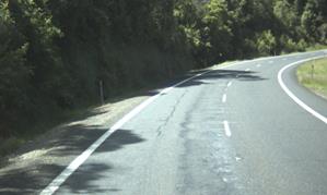
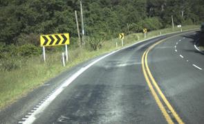
FIGURE 3
– Lack of Signage Infrastructure on Route
Our team also identified that there are a number
of crashes present within the current passing lanes along the route. As
identified within this response there is significant concern from route users
and local communities as to the potential for increased frustration for drivers
of the route and specifically the possibility that this results in unsafe
passing movements. Given the crash history within the current passing
lanes we share similar concerns and particularly wonder how the passing lanes
will be able to operate effectively under an 80km/h operating environment where
vehicles will be unable to overtake heavy traffic (with the exception of steep
uphill grades).
In selecting to reduce speed limits, and given
the lack of supporting information or evidence, Waka Kotahi can have no real
confidence that the speed reduction will deliver the safety benefits
desired. Moreover, the insufficient technical assessments completed and
the lack of recognition or consideration of the surrounding land-uses and the
current condition/presence of infrastructure should be cause for real concern.
It is our opinion that Waka Kotahi would be
remiss to adopt reduced speed limits at this time without stepping back and
adopting a more detailed assessment of the route which adequately reflects the
robustness of analysis required to justify a change of this scale. There are
clear gaps in the approach adopted and we have real concern that it is driving
an inappropriate outcome for the route.
HDC Recommendation
Our submission is clear that HDC oppose the proposed speed
limit reductions in their current form. We have formed this view based on
the serious concerns we hold with regards to the technical assessments
completed, the community and affected party concerns, the scale of the economic
impact on local communities and national industry and the lack of any
consideration of the infrastructure condition and response required for this
route.
We strongly believe that the consultation and engagement
approach adopted is both inappropriate and inadequate. We support our
community voice and share their concerns with regards to the potential negative
safety implications of a proposed speed limit reduction across this length of
network combined with the significant and detrimental time and economic impacts
this change would have.
Our own technical assessment of the corridor shows serious
gaps in the work completed by Waka Kotahi and demonstrates that there is
significant opportunity for infrastructure to play a part in this safety
response, some of which is at the most basic level of intervention.
Furthermore, our findings suggest that the Waka Kotahi assessment has not
adequately considered the land-use and environment of the route and have not
tested whether alternative options would better serve the desired outcomes.
We ask that Waka Kotahi do not progress the speed limit
change at this time. Whilst we support speed management across some parts
of the route, such as around Te Pohue and Te Haroto villages, we cannot support
the proposal as it stands. We request that Waka Kotahi complete a
comprehensive corridor study along the SH5 route which considers a combination
of speed management and significant infrastructure improvements in addressing
the safety risks present along this route. We would like to understand
the short, medium and long term vision and investment plan for this corridor to
better understand the appropriateness of each solution and how they complement
each other. We are happy to be involved in scoping this work and would be
happy for our team to be involved in contributing to the study and the study
outcomes. We also request that proactive and enhanced consultation and
engagement with local communities is embedded within the route study to aid buy
in of the ultimate solution.
SH51 Speed Limit Submission
Hastings District Council have previously indicated its
position to Waka Kotahi regarding the State Highway 51 speed limit through the
Waipatu area – sections 6 & 7 in the Technical Assessment. During our
recent speed limit review on the local roads in Waipatu, it was considered
important that the side roads be aligned with the State Highway 51 speed limit
and as such we developed the speed limit changes for the adjoining roads based
on this position, being 50km/h from Kenilworth Road to St Georges Road, and
60km/h through to the Karamu Stream Bridge (see plan below). With the exception
of Elwood Road, the local road speed limit changes are now in place.
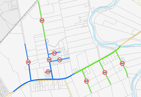
It was disappointing that the speed limit review of SH51
was delayed and unable to be aligned and integrated with our speed limit review
as indicated by Waka Kotahi in 2019. It is also noted that both the Technical
Assessment and Internal Review were completed prior to the corridor
improvements and urbanisation project. The designs used in the assessment and
review have since been superceded, and now include a limesand shared path from St
Georges Road to Ruahapia Road.
Council support the proposed speed limit reductions on
SH51, with the following exceptions:
Section 7 (Kenilworth to St Georges)
Hastings District Council is in support of a speed limit
reduction on State Highway 51 through Waipatu to complement the
transformational works and urbanisation of the road through the settlement,
however it is the view of Council and the community that a 60km/h speed limit
would be too high on this now urban section of Waipatu (Kenilworth to St
Georges) and that the proposed speed limit reduction should extend beyond
Waipatu Settlement Road and the busy Bay Espresso café. The geometric
design for the corridor improvements and urbanisation project used a design
speed of 50km/h, which was assumed based on the existing SAAS in MegaMaps.
The section from Kenilworth Road to St Georges now has kerb
and channel both sides, a concrete shared path on the southern side and
pedestrian refuges to be built as part of this project. There is also an
increase in development in the area; Papakainga housing is being built
currently, with more to be built in the near future, and the intersection with
Bennett Road will see a significant increase in traffic volume when Kura is
opened within the next few years.
The default SAAS for this section is 50km/h, and with the
corridor improvements this remains the case when the length of the section is
extended to include the above. Council agree that the safe and appropriate
speed through this section is 50km/h, and ask that Waka Kotahi adopt a 50km/h
speed limit from Kenilworth to beyond Bay Espresso café.
Section 6 (St Georges to Karamu Stream Bridge)
It is disappointing that Waka Kotahi have ignored the
findings of the Technical Assessment in this section by deciding not to propose
a reduction in speed limit.
With the transformational works being undertaken up to
Ruahapia Road, the Karamu Stream Bridge becomes a natural threshold where a
speed limit change is logical, as this section differs significantly to the
section to the east (section 5). Running alongside the road is now a limesand
shared path, where in some places lane separators are required due to
insufficient shoulder width. The road widening to allow for a flush median also
moves the traffic lanes closer to roadside hazards, which were assessed as
severe in the Technical Assessment.
Council agree with the findings of the Technical Assessment
that the SAAS for this section is 60km/h, and would like to understand why Waka
Kotahi have deviated from the technical advice in this instance.
Yours
sincerely,


Nigel
Bickle, Sandra
Hazlehurst, Craig
Thew,
Jag Pannu,
Chief
Executive Mayor GM
Asset Management Transportation Manager
Copy
to: Hon Stuart Nash, Hon Meka Whaitiri, Anna Lorck, Hon Michael Woods, Sir
Brian Roche, Nicole Rosie.
|
Item 11 Rural Transportation Activities
Report
|
|
Transport
(USE ROAD CONTAINER FOR INDIVIDUAL ROADS) - Roads General (See notes) - 11_RCB
Photos - March 2021 to April 2021
|
Attachment 2
|
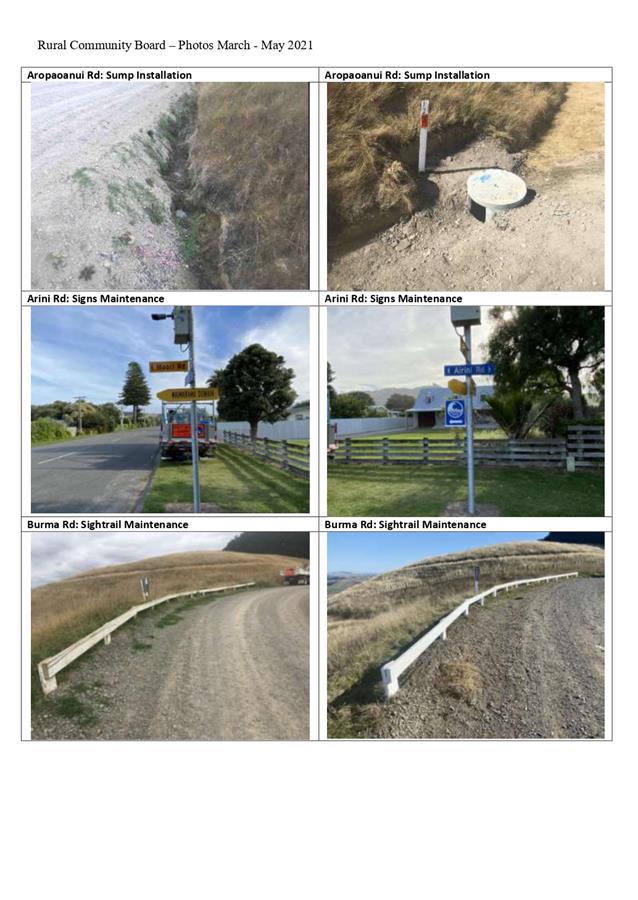
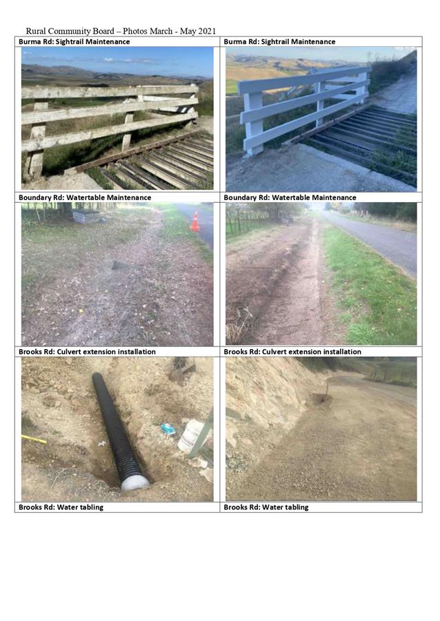
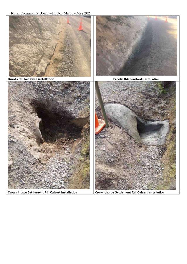
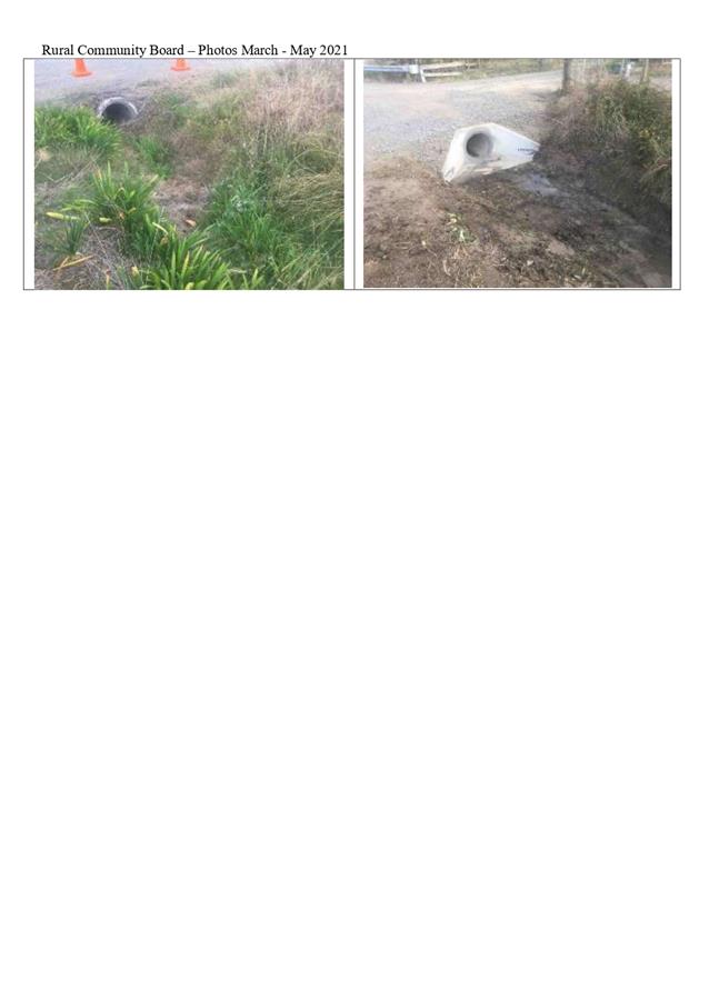
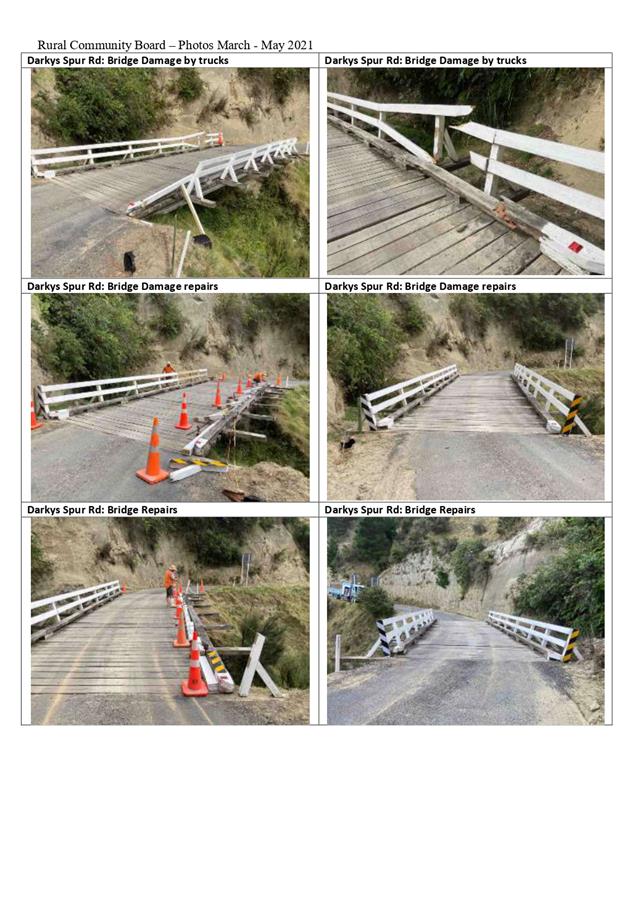
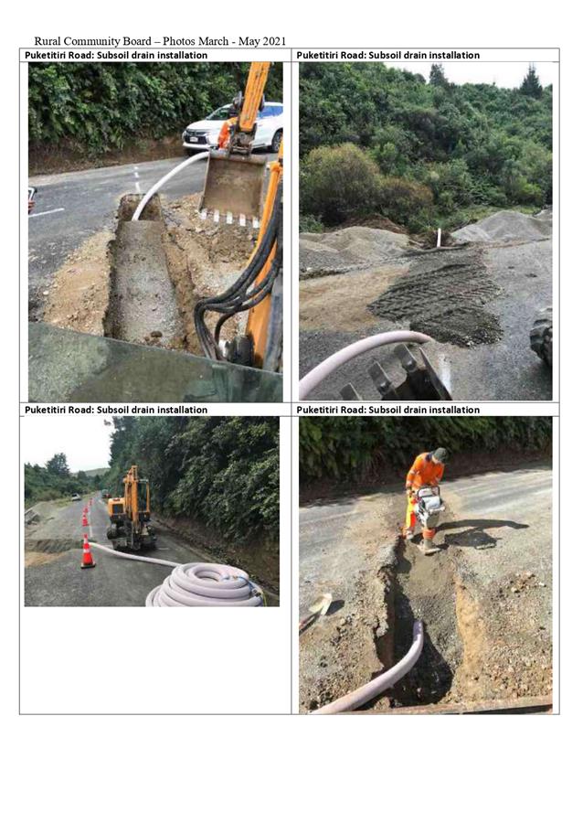
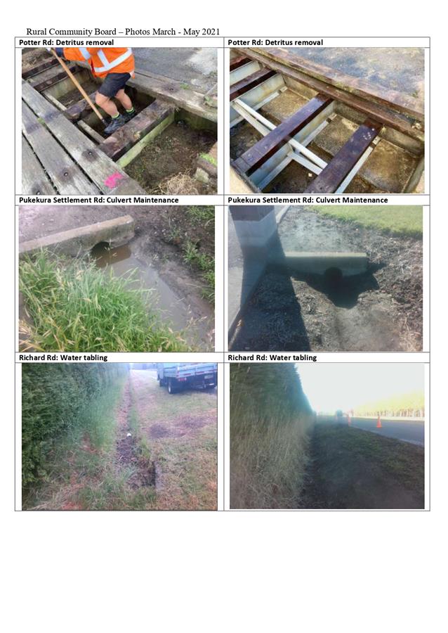
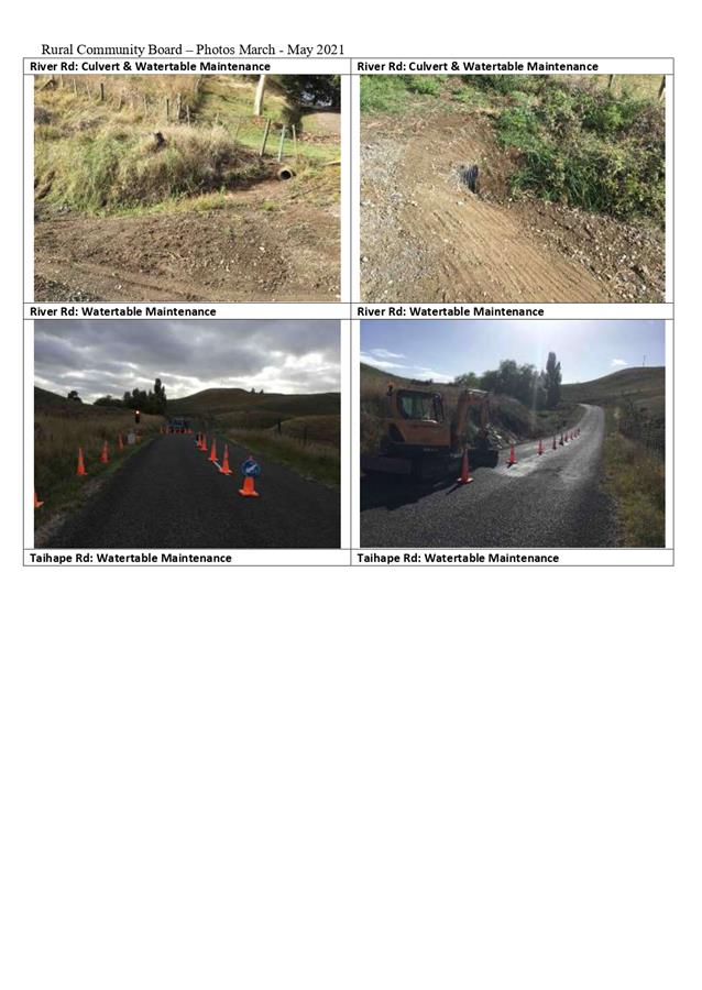
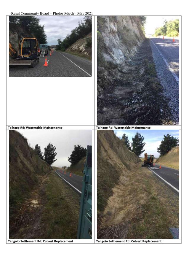
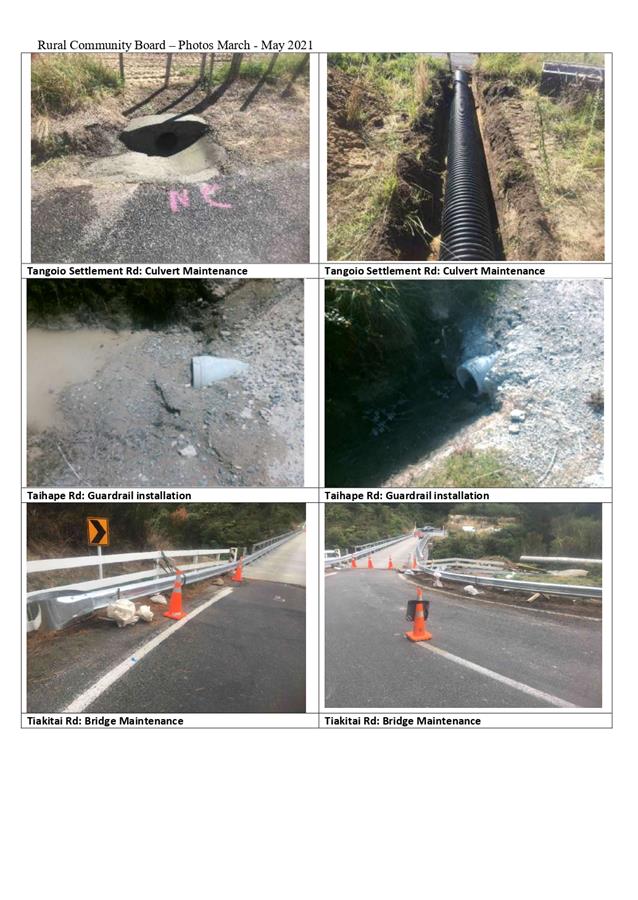
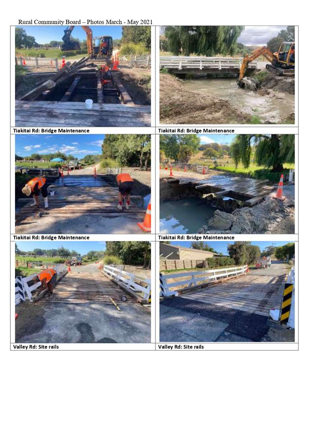
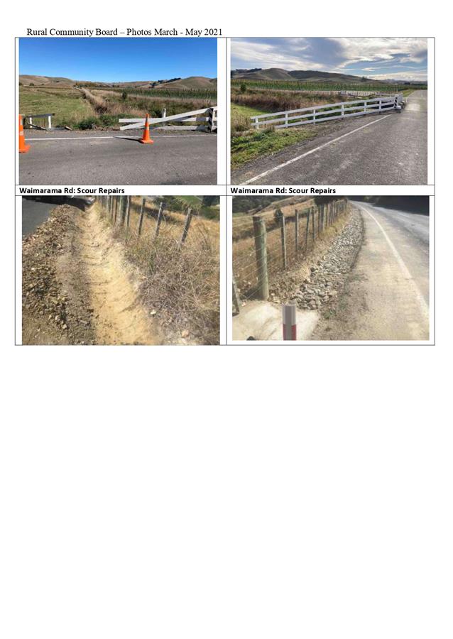
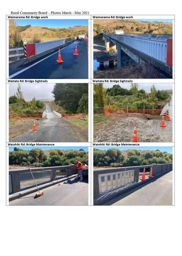
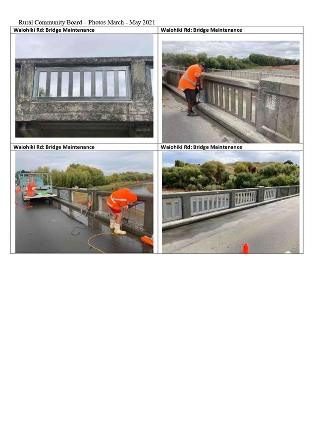
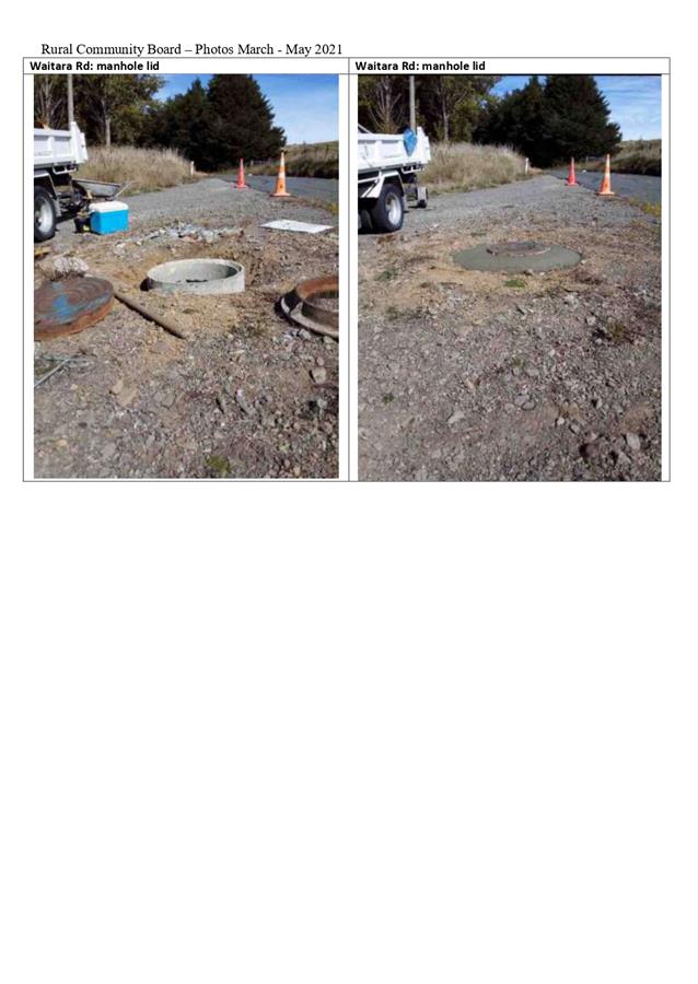
 Te Hui o Te Kaunihera ā-Rohe o Heretaunga